Coffee Creek Culvert (7) - Luther, OK
Posted by: Groundspeak Premium Member hamquilter
N 35° 41.756 W 097° 14.447
14S E 659168 N 3951649
This culvert carries run-off from nearby Coon Creek.
Waymark Code: WMXRR1
Location: Oklahoma, United States
Date Posted: 02/21/2018
Published By:Groundspeak Premium Member T0SHEA
Views: 0

This culvert is one of many along Coffee Creek Road, and is located about 3/4 mile east of Indian Meridian Road, and two miles north of Route 66, northwest of the town of Luther. 
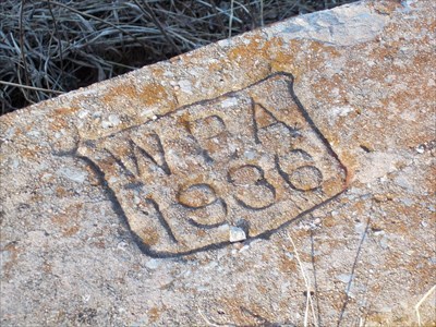
The culvert is about 2 ft. high and 6 ft. wide on one side of the road, and 3 ft. high on the other. There are several homes in the area, and Coon Creek runs north-south just west of the culvert. The WPA stamp indicates it was built in 1936.

The link shown below gives a nice description of the road, bridge and culvert work done in Oklahoma during the 1930s.

Project type: Other

Date built or created: 1936

City: Luther, OK

Condition: Good upkeep with a little wear and tear

Website for additional information: [Web Link]

Location: Not listed

Visit Instructions:
To help give a different perspective and to better the waymark for future visitors please tell us about your visit and upload a favorite photograph you took of the waymark.

Although visiting this waymark in person is the only thing required of you to receive credit for your visit, taking the time to add this information is greatly appreciated.
Search for...
Geocaching.com Google Map
Google Maps
MapQuest
Bing Maps
Nearest Waymarks
Nearest WPA Projects
Nearest Geocaches
Create a scavenger hunt using this waymark as the center point
Recent Visits/Logs:
There are no logs for this waymark yet.