
Hiwassee (3) Culvert - Arcadia, OK
Posted by:  hamquilter
N 35° 41.160 W 097° 18.036
14S E 653775 N 3950452
This is one of several culverts in a three mile stretch of Hiwassee Road.
Waymark Code: WMXRM4
Location: Oklahoma, United States
Date Posted: 02/20/2018
Views: 0
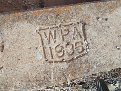
During the 1930s, the WPA constructed numerous culverts and bridges in the area east and northeast of Oklahoma City. These were desperately needed to make these farm-to-market roads passable in bad weather, and during rains. The work also provided income for the economically distressed families of Oklahoma. This culvert traverses Hiwassee Road about 1-1/2 miles north of Route 66.
This culvert was built in 1936. The concrete tunnel is about 3 ft. high and 5 ft. wide. It is located just south of a private driveway and south of a wide electric utility right-of-way. There doesn't seem to be a creek at this location. The top of the culvert was overgrown and the WPA shield was covered with years of dirt. It was time to bring out the broom (see gallery).
The web site below "A New Deal for Oklahoma" documents the extensive road and bridgework done during the 1930's.