Blason de Cervières - Cervières, Paca, France
Posted by: Groundspeak Premium Member YvesProvence
N 44° 52.252 E 006° 43.540
32T E 320345 N 4971122
Le Blason de Cervières
Waymark Code: WMWFGN
Location: Provence-Alpes-Côte d'Azur, France
Date Posted: 08/28/2017
Published By:Groundspeak Premium Member Dorcadion Team
Views: 2

FR Cervières est située à 9 km de Briançon sur la route des Grandes Alpes au pied du col d'Izoard (2 364 m) et en dessous de la plaine d'altitude du Bourget. Le village est situé à 1 620 m d'altitude, au pied de hautes montagnes marquant la limite entre le Briançonnais et le Queyras (pic de Rochebrune, 3 323 m).

L'existence du village de Cervières est attestée depuis le Haut Moyen Âge. À l'origine il était initialement installé sur les hauteurs, peut-être en raison des inondations. Du xive siècle au xve siècle, les habitants se rapprochèrent de la Cerveyrette à cause du manque d'eau. Les plus anciennes maisons que l'on peut encore observer datent du xvie siècle.

Le village appartint, entre le xive siècle et la Révolution française (création des départements), au territoire de la République des Escartons (dans le Haut Dauphiné) qui regroupait une douzaine de localités autour de Briançon et d'Oulx (commune située actuellement dans le Piémont italien). Cette République des Escartons bénéficiait de privilèges fiscaux et d'une autonomie administrative vis-à-vis des Royaumes de France et de Piémont.

Le Blason
On peut le voir sur sur chaque coté du pont supérieur du village et au milieu, sur le grand pot de fleur.


Blasonville fr Cervières 05


EN Cervières is located 9 km from Briançon on the Grandes Alpes road at the foot of the Izoard pass (2,364 m) and below the altitude plain of Le Bourget. The village is located at an altitude of 1,620 meters, at the foot of high mountains marking the limit between the Briançonnais and the Queyras (peak of Rochebrune, 3,323 m).

The existence of the village of Cervières is attested since the High Middle Ages. Originally it was initially installed on the heights, perhaps due to flooding. From the fourteenth century to the fifteenth century, the inhabitants approached the Cerveyrette because of the lack of water. The oldest houses that can still be seen date from the sixteenth century.

The village belonged between the fourteenth century and the French Revolution (creation of the departments), to the territory of the Republic of the Escartons (in Haut Dauphiné), which gathered a dozen localities around Briançon and Oulx (commune currently located in the Italian Piedmont). This Republic of the Escartons enjoyed fiscal privileges and administrative autonomy vis-à-vis the Kingdoms of France and Piedmont.

Coat of arms
It can be seen on each side of the upper bridge of the village and in the middle, on the large flower pot.
Bearer of Coat of Arms: Town

Full name of the bearer: Blason de Cervières

Where is Coat of Arms installed (short description) ?:
It can be seen on each side of the upper bridge of the village and in the middle, on the large flower pot.


Material / Design: Stone

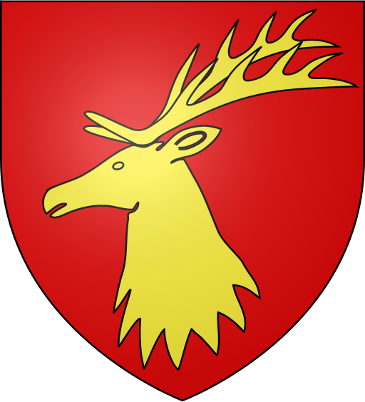
Blazon (heraldic description):
De gueules à la tête de cerf d’or.


Address:
Pont sur la Cerveyrette 05100 Cervières


Web page about the bearer of Coat of Arms (if exists): [Web Link]

Web page about the structure where is Coat of Arms installed (if exists): Not listed

Visit Instructions:
Logging requirements: Please upload your own personal photo of the coat of arms. You or your GPS can be in the picture, but it’s not a requirement.
Search for...
Geocaching.com Google Map
Google Maps
MapQuest
Bing Maps
Nearest Waymarks
Nearest Coats of Arms
Nearest Geocaches
Create a scavenger hunt using this waymark as the center point
Recent Visits/Logs:
There are no logs for this waymark yet.