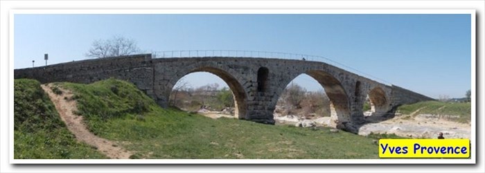
Le Pont Julien - Bonnieux, Paca, France
Posted by: Groundspeak Premium Member YvesProvence
N 43° 51.786 E 005° 18.384
31T E 685340 N 4859253
Le Pont Julien est un pont romain, traditionnellement daté de l'an 3 av. J.-C., au débouché du défilé de Roquefure, à 5 km au nord de Bonnieux (Vaucluse, sud de la France) et à 8 km à l'ouest de la ville d'Apt.
Waymark Code: WMWEN2
Location: Provence-Alpes-Côte d'Azur, France
Date Posted: 08/24/2017
Published By:Groundspeak Premium Member fi67
Views: 7

FR * Situation Il était situé sur la voie Domitienne (via Domitia), voie romaine qui reliait Narbonne (Colonia Narbo Martius) à Turin (Augusta Taurinorum). Il doit son nom à la proximité d'Apt, appelée alors Colonia Apta Julia. Il est classé « Monument historique ».

La chaussée antique de la voie, bien visible en aval et en amont du pont, franchissait le lit du Calavon (ou Coulon) suivant un tracé en baïonnette.

* L'ouvrage
Le pont, 80 mètres de long, d'une portée de 46 m, 6 m de large, et la chaussée de 4,20 m, haut de 11,50 m.

Il se compose de trois arches en plein cintre, l'arche centrale étant plus élevée que celles qui la flanquent au nord et au sud ; les piles intermédiaires sont percées de grandes baies cintrées pour faciliter l'évacuation des eaux en période de crues (dégueuloirs) et munies en amont d'avant-becs semi-circulaires.

Bâti en grand appareil de calcaire provenant de carrières du Luberon, il remplaçait un pont plus ancien, dont on perçoit les traces autour des piles.

Il a été intégré au réseau routier (route départementale 108) jusqu'au printemps 2005, soit plus de 2 000 ans d'exploitation, jusqu'à la mise en service d'une déviation et d'un nouveau pont à proximité, afin de le préserver.

* Loisirs Aux abords, on découvrira avec intérêt, en aval le tracé de la route antique, bien visible sur 6 km, et en amont les gorges de Roquefure.

Depuis 2005 le pont Julien est emprunté par la véloroute du Calavon, projet cofinancé par l'Union Européenne (FEDER), la région et le Conseil Général du Vaucluse, entièrement balisée et sécurisée et qui, à terme, traversera toute la vallée du Calavon à partir de Cavaillon pour relier Volx dans le département des Alpes-de-Haute-Provence.

Au départ du Pont Julien qui se situe à 5 km du village de Bonnieux, deux directions sont possibles :
=> à l'est, vers Apt qui se situe à 10 km et Saint-Martin-de-Castillon
=> à gauche (à l'Ouest), vers Beaumettes (10 km) et Cavaillon (tronçon en cours de réalisation)


EN * Location It was located on the Domitian Way (Via Domitia), a Roman road that linked Narbonne (Colonia Narbo Martius) to Turin (Augusta Taurinorum). It owes its name to the proximity of Apt, then called Colonia Apta Julia. It is classified as a historical monument.

The antique causeway of the road, clearly visible downstream and upstream of the bridge, crossed the bed of the Calavon (or Coulon) following a bayonet line.

* The book
The bridge, 80 meters long, with a reach of 46 m, 6 m wide, and the roadway of 4,20 m, high of 11,50 m.

It consists of three semicircular arches, the central arch being higher than those which flank it to the north and south; The intermediate piers are pierced by large arched bays to facilitate the evacuation of water during periods of floods (disgusters) and provided upstream of semicircular pre-beaks.

Built in large limestone from the quarries of the Luberon, it replaced an older bridge, whose traces are perceived around the piers.

It was integrated into the road network (departmental road 108) until spring 2005, ie more than 2,000 years of operation, until a deviation and a new bridge were put into operation in order to Preserve it.

* Recreation On the outskirts, you will discover with interest, downstream the route of the ancient road, clearly visible for 6 km, and upstream the gorges of Roquefure.

Since 2005, the Julian bridge has been used by the Calavon bike route, a project co-financed by the European Union (FEDER), the region and the Vaucluse Council, which is fully signposted and secured and which will eventually cross the entire Calavon valley. From Cavaillon to connect Volx in the Alpes-de-Haute-Provence department.

From the Pont Julien which is 5 km from the village of Bonnieux, two directions are possible:
=> to the east, towards Apt which is 10 km and Saint-Martin-de-Castillon
=> to the left (to the west), to Beaumettes (10 km) and Cavaillon (section in progress)
Geocaching LE PONT JULIEN VIA DOMITIA
Length of bridge: 46 m

Height of bridge: 11,50

What type of traffic does this bridge support?: pedestrians, bike, hikers

What kind of gap does this bridge cross?:
The Calavon River


Date constructed: -3 av JC

Is the bridge still in service for its original purpose?: No

Name of road or trail the bridge services: Old D108

Location:
Bonnieux, Paca, France


Visit Instructions:
Please submit a photo(s) taken by you of your visit to the location (non-copyrighted photos only). GPS photos are also accepted with the location in the background, and old vacation photos are accepted. If you are not able to provide a photo, then please describe your visit or give a story about the visit. If the bridge location prevents you from taking a safe photograph, then please do not stop to take the photo. Safety is more important.
Search for...
Geocaching.com Google Map
Google Maps
MapQuest
Bing Maps
Nearest Waymarks
Nearest Arch Bridges
Nearest Geocaches
Create a scavenger hunt using this waymark as the center point
Recent Visits/Logs:
Date Logged Log User Rating  
Blogi visited Le Pont Julien - Bonnieux, Paca, France 06/30/2015 Blogi visited it
blackjack65 visited Le Pont Julien - Bonnieux, Paca, France 08/09/2007 blackjack65 visited it

View all visits/logs