|
 Cimetière de Talmont-sur-Gironde - Talmont-sur-Gironde, France Posted by:  pmaupin pmaupin
N 45° 32.094 W 000° 54.541
30T E 663260 N 5044500
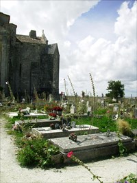
[EN] The cemetery of Talmont is located at the foot of the church, it is enclosed walls, except to the south, on the side of the church.
[FR] Le cimetière de Talmont est situé au pied de l'église, il est clos de murs, sauf au sud, du côté de l'église
Waymark Code: WMVZN4
Location: Nouvelle-Aquitaine, France
Date Posted: 06/17/2017
Views: 1

 To the north, a pedestrian door opens onto the garden of the presbytery. To the east, the entrance to the cemetery is marked by two masoned pillars, surmounted by old cannon balls. To the north, a pedestrian door opens onto the garden of the presbytery. To the east, the entrance to the cemetery is marked by two masoned pillars, surmounted by old cannon balls.
Tombs usually have their heads facing the west. Almost all of them have a tombstone and / or a headstone. There is only one iron cross. On the other hand, there are a large number of long, raised tombstones, carved in the form of a sarcophagus and placed on two feet (the deceased is buried in the ground, at the right of the stone). The decoration of this type of tombstone is limited, at best, to moldings. Other tombstones, close to the latter, are carved in the shape of a cross.
The Talmont cemetery, situated at the foot of the church and at the west end of the promontory, was probably already in this place in the Middle Ages. Sarcophagi and bones were discovered near the church: the lid of a medieval sarcophagus, discovered at the foot of the southwest wall of the transept of the church in 1934-1935, is visible in the museum of Talmont ; By sweeping the rock, the storm of 1999 revealed traces of pits near the head of the church; Remains of skeletons were even detected in 2010. In the medieval period, another cemetery was apparently located at the tip of the Caillaud.
At the beginning of the 18th century, one of Talmont's plans by Claude Masse mentions the cemetery and his cemetery cross. Until recently, the cemetery included a section reserved for Protestants. Located at the western end, it was separated from the rest of the cemetery by an alley, the rue des Canons, now extinct.
In the spring of 1853, the cemetery was enlarged (its area increased to 1200 square meters) and its fence wall was rebuilt by Paul Martin, a public works contractor. The pillars of the gates are raised, and the ground of the cemetery is flattened. In November, the municipality decided to award first concessions, demarcated in the northeast corner of the cemetery. A plan of the cemetery is then established by Michel Augier, geometer residing in Talmont.
Most of the tombs and tombstones now in the cemetery date back to the second half of the 19th century. Many have been reused in recent decades. The oldest date from the years 1830-1840.
Sources : Le Cimetière
 Au nord, une porte piétonne ouvre sur le jardin du presbytère. A l'est, l'entrée du cimetière est marquée par deux piliers maçonnés, surmontés d'anciens boulets de canon. Au nord, une porte piétonne ouvre sur le jardin du presbytère. A l'est, l'entrée du cimetière est marquée par deux piliers maçonnés, surmontés d'anciens boulets de canon.
Les tombeaux ont le plus souvent la tête placée vers l'ouest. Presque tous présentent une pierre tombale et/ou une stèle de tête. On ne dénombre qu'une seule croix en ferronnerie. On compte en revanche un nombre important de pierres tombales longilignes, surélevées, taillées en forme de sarcophage et posées sur deux pieds (le défunt est inhumé en terre, au droit de la pierre). Le décor de ce type de pierre tombale est limité, au mieux, à des moulurations. D'autres pierres tombales, proches de ces dernières, sont sculptées en forme de croix.
Le cimetière de Talmont, situé au pied de l'église et à l'extrémité ouest du promontoire, se trouvait probablement déjà à cet endroit au Moyen Age. Des sarcophages et des ossements ont été mis au jour tout près de l'église : le couvercle d'un sarcophage médiéval, découvert au pied du mur sud-ouest du transept de l'église en 1934-1935, est visible au musée de Talmont ; par ailleurs, en balayant le rocher, la tempête de 1999 a fait apparaître des traces de fosses près du chevet de l'église ; des restes de squelettes ont même été décelés en 2010. A l'époque médiévale, un autre cimetière se trouvait semble-t-il à la pointe du Caillaud.
Au début du 18e siècle, un des plans de Talmont par Claude Masse mentionne le cimetière et sa croix de cimetière. Jusqu'à une époque récente, le cimetière comprenait une partie réservée aux protestants. Située à l'extrémité ouest, elle était séparée du reste du cimetière par une ruelle, la rue des Canons, aujourd'hui disparue.
Au printemps 1853, le cimetière est agrandi (sa superficie est portée à 1200 mètres carrés) et son mur de clôture est reconstruit par Paul Martin, entrepreneur de travaux publics. Les piliers des portails sont relevés, et le terrain du cimetière est aplani. En novembre, la municipalité décide de procéder à l'attribution de premières concessions, délimitées dans l'angle nord-est du cimetière. Un plan du cimetière est alors établi par Michel Augier, géomètre demeurant à Talmont.
L'essentiel des tombeaux et pierres tombales aujourd'hui présents dans le cimetière, remonte à la seconde moitié du 19e siècle. Beaucoup ont été réutilisés au cours des dernières décennies. Les plus anciens datent des années 1830-1840.
Sources : Le Cimetière
Name of church or churchyard: Church of Sainte-Radégonde/Eglise Sainte-Radégonde

Approximate Size: Medium (51-100)
|
Visit Instructions:
VISIT LOGS
1. The waymark coordinates must be personally visited.
2. Give the date and a description of your visit
3. Post at least one photo taken at the time of your visit
|