|
 Wildfire Commemorative Park - West Kelowna, British Columbia Posted by:  T0SHEA T0SHEA
N 49° 49.497 W 119° 39.222
11U E 309139 N 5522546
A small park has been created in Lower Glenrosa to commemorate the wildfires of 2009 which caused the evacuation of 12,500 residents and destroyed three homes.
Waymark Code: WMV5XH
Location: British Columbia, Canada
Date Posted: 02/28/2017
Views: 0
B & K lived in Westbank at the time of the 2009 fires, as well as the 2003 Kelowna fire which destroyed around 300 homes. We were able to watch the progress of the Glenrosa fire from our kitchen window. It became a bit of a scary time for us, even though we were over a mile from the fire, as we were east of the fire and a substantial west wind had picked up that day. Fortunately for almost everyone, a huge attack on the fire by water bombers, helicopters and ground equipment and personnel turned the tide and saved all but three homes.
Wildfire Commemorative Park
Council agreed to name a new park located on Glenrosa Road “Wildfire Commemorative Park”. The new park was constructed in partnership with Tree Canada which provided a grant of $15,000 towards reforestation. The park is intended to commemorate the Glenrosa and Rose Valley wildfires of July 2009 and was located on public land adjacent to Glenrosa Road which provides a scenic view of the fire-affected areas in Glenrosa. The park will be officially opened May 27, [2010] at 2 p.m.
From the District of West Kelowna
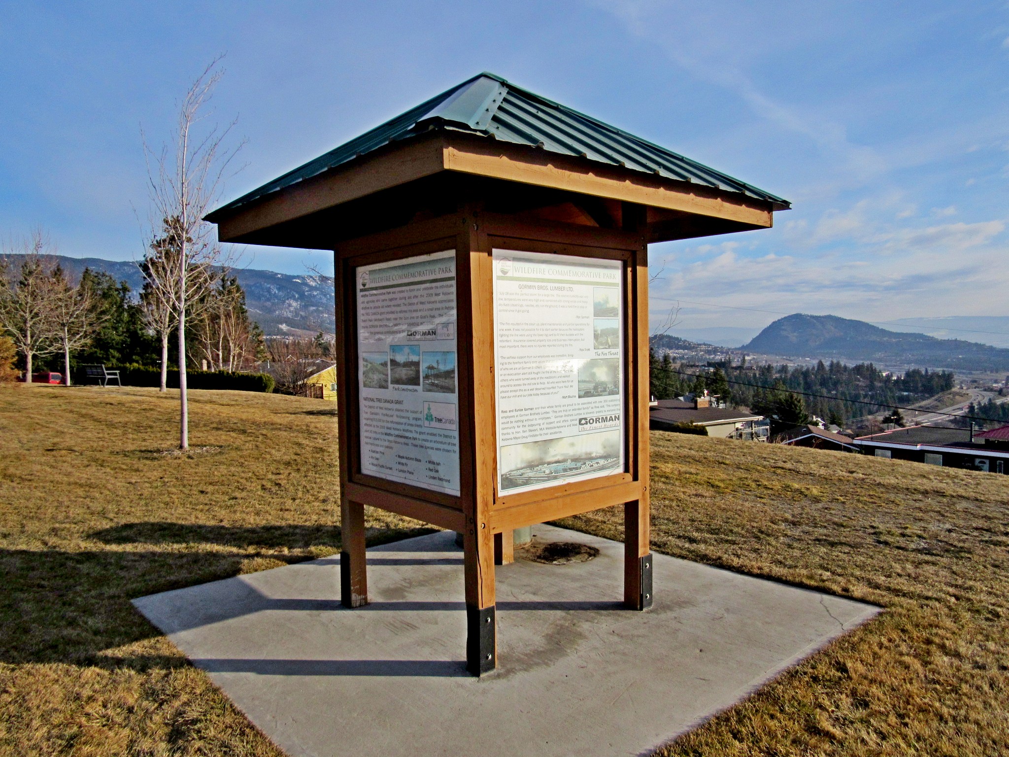
In the park is a four sided informational kiosk with signs on each side relating the story of the 2009 fires and the subsequent renaming of this little park. The park itself lies alongside Glenrosa Road, adjacent to the site of the Glenrosa fire. It is a long, narrow, open grassed area with newly planted trees and a line of four benches affording a view of Lower Glenrosa, West Kelowna and Lake Okanagan to the east and the burned area, immediately west, across Glenrosa Road. In this spot the fire was stopped at Glenrosa road, saving all the homes to the east of it.
WILDFIRE COMMEMORATIVE PARK
Wildfire Commemorative Park was created to honor and celebrate the individuals and agencies who came together during and after the 2009 West Kelowna Wildfires to provide aid where needed. The District of West Kelowna appreciates the TREE CANADA grant provided to reforest this area and a small area in Pebble Beach Park (Whitworth Road) near the burn area on Goat's Peak. The District thanks GORMAN BROTHERS LUMBER and WISHBONE INDUSTRIES LTD. for the generous contributions to this commemorative park.
West Kelowna Wildfires 2009 - For five days, from July 18 to 22, 2009, two forest fires threatened the safety of residents and property in West Kelowna, forcing the evacuation of approximately 12,500 residents.
On July 18 at 2:30 p.m. West Kelowna Fire Rescue were alerted that a small fire was burning in the forested hills buffering the Glenrosa neighborhood, not far from the Gorman Sawmill. The fire appeared to grow quickly and the wind picked up.
The Regional Emergency Operation Centre was operational by 3 p.m. with support from neighboring municipalities. Under one hour later, Mayor Doug Findlater signed the State of Emergency, allowing the municipality to evacuate the 3,000 homes in the Glenrosa neighborhood.
Emergency Social Services were mobilized and opened a Reception Centre at Royal LePage Place for evacuees. The Glenrosa fire spread quickly fueled by an unusual 60 km/hr. wind. It grew to 50 hectares in size by 7 p.m. and spread east across Highway 97, burning the hills above the Gellatly area (Goat's Peak). The highway was closed and by 8 p.m., the Gellatly Bay area was evacuated, 1,500 more homes.
West Kelowna Wildfires 2009 - At 11 p.m. on July 18, 2009, the Glenrosa/Gellatly fire had grown to 300 hectares, and it was announced a second fire was burning in the Rose Valley area, forcing more evacuations. The Rose Valley Fire grew to 30 hectares by 1 a.m. and the entire Rose Valley community was evacuated in the middle of the night, 420 homes.
At 8 a.m. the following day, it was announced that three Glenrosa homes had been destroyed in the fire. No injuries were reported.
The fires burned for several days. At the height of the emergency 12,500 people were under evacuation order. Thousands more were placed on Evacuation Alert and were prepared to leave at a moment's notice. West Kelowna Fire Rescue and BC Forest Service held unified command throughout the West Kelowna fire threat. Hundreds of ground personnel, dozens of water bombers, helicopters and water tankers were deployed, and the fires were fully contained by Wednesday July 22 with all Evacuation Orders lifted at 10:30 a.m. All Evacuation Alerts were lifted at 11 a.m. on July 26.
The District set up a Fire Relief Trust Fund to accept donations, which were distributed to affected property owners through a Community Needs Committee. The Canadian Red Cross set up a West Kelowna Recovery Centre.
The District set up a Fire Relief Trust Fund to accept donations, which were distributed to affected property owners through a Community Needs Committee. The Canadian Red Cross set up a West Kelowna Recovery Centre. Throughout the crisis, the community came out in droves to support each other, volunteering time, donating supplies and opening their homes to those in need.
transcribed from sign
Name: Wildfire Commemorative Park

Street Location: 3806 Woodell Road - West Kelowna, BC
Local Municipality: District of West Kelowna
State/Province, etc.: British Columbia
Country: Canada
Web Site: [Web Link]
Memorial/Commemoration: 2009 West Kelowna Wildfires
Date Established: May 27, 2010
Picnic Facilities: None, benches only
Recreational Facilities:
None
Monuments/Statues: Not listed
Art (murals/sculpture, etc.): Not listed
Fountains: Not listed
Ponds/Lakes/Streams/Rivers/Beach: Not listed
Special Events: Not listed
Traditional Geocaches: Not listed
|
Visit Instructions:
One photo of the park that is a different view from the one on the page, and give the date and description your visit.
Add any additional information that you may have about this park. A GPSr photo is NOT required.
Recent Visits/Logs:
| There are no logs for this waymark yet. |
|
|
|
|