|
 P-Bar Ranch - Fountain Hills, AZ Posted by:  T0SHEA T0SHEA
N 33° 36.904 W 111° 43.999
12S E 431975 N 3719717
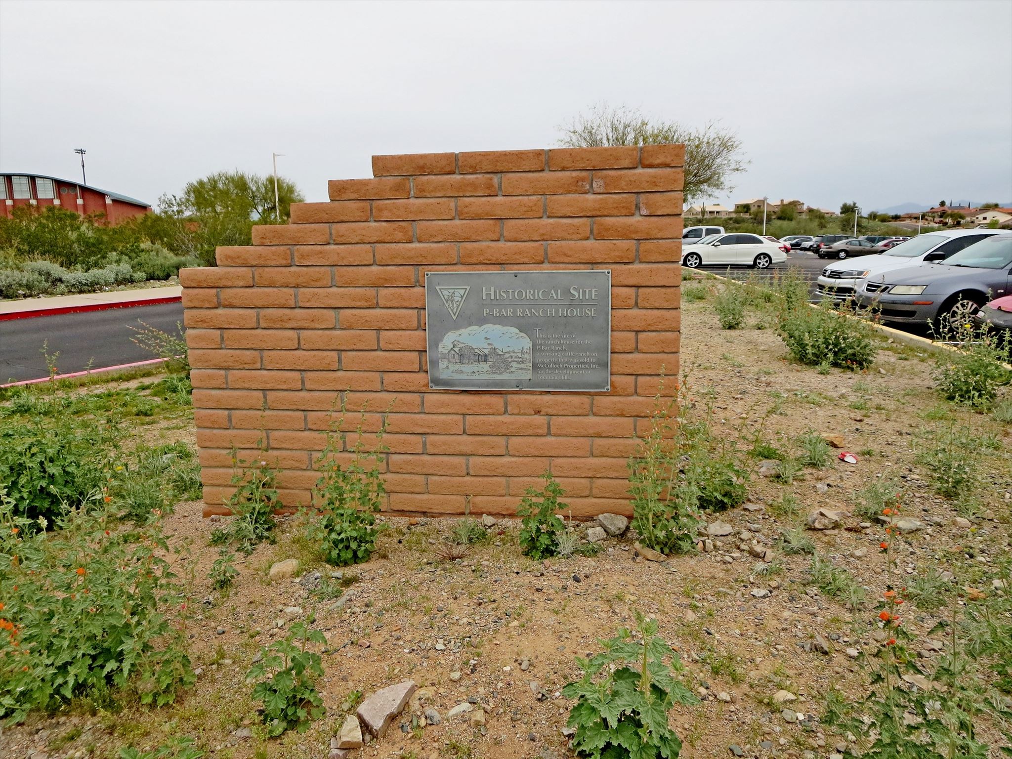
In the parking lot of the Fountain Hills High School, this marker is mounted on a low adobe wall resembling the remaining corner of a building, ie, the ranch house referred to in the marker.
Waymark Code: WMV5QQ
Location: Arizona, United States
Date Posted: 02/27/2017
Views: 4
As pioneers moved into Arizona Territory in the 1860s and 1870s, they looked for fertile farm land and grass for their cattle and sheep. The lower Verde River valley had both, plus adequate water. It also had Fort McDowell, which provided protection against Indian raids.
The primary sheep trail in the state, the Heber-Reno Driveway, is located just a few miles east of the Verde River and is still being used.
Fountain Hills and McDowell Mountain Park were once a 33,000 acre cattle ranch. Homesteaded in the early 1900s by Henry Pemberton, the ranch passed to pioneers "Pink" Cole and son Bill, then to Lee and Delsie Barkdoll in 1935, and to Defoe and second husband Dick Robbins. During the BarkdolL/Robbins years (1935-1955), area cattlemen pastured and watered their stock on the P-Bar for about a dollar a month per head and one cent per pound gained- Fort McDowell Indians helped with the roundups.
From the River of Time Museum
The marker actually is two markers, the one on the south facing wall bearing a likeness of the ranch house and the following text:
HISTORICAL SITE
P-BAR RANCH HOUSE
This is the site of
the ranch house for the
P-Bar Ranch,
a working cattle ranch on
property that was sold to
McCulloch Properties, Inc.
for the development of
Fountain Hills.
On the east facing wall is further text, which is reproduced below.
P-Bar Ranch
A MONUMENT FOR FUTURE GENERATIONS
BY THE FOUNTAIN HILLS & LOWER VERDE
RIVER VALLEY HISTORICAL SOCIETY
Fountain Hills is located on land once used as an active cattle ranch. The P-Bar Ranch covered 33,000 acres. The ranch was used for brood cows and their calves. It was described as "one of the better ranches in the area with dependable grass." The Page Land & Cattle Company sold the property in 1968 to McCulloch Oil Corporation for the development of Fountain Hills. The former ranch house, which was located on this site, served as the engineering headquarters for the original development of the community. In 1976, the ranch house was renovated and used for three years as the community's first arts and crafts center. It was demolished in 1979.
Marker Name: P-Bar Ranch

Type of history commemorated: Place
County: Maricopa
Name of any agency/ agencies setting marker:
Fountain Hills & Lower Verde River Valley Historical Society
Year placed: 1997
|
Visit Instructions:
To claim a log for this waymark, some proof of visit is required. This proof can be a simple gps photo, a photo with your mascot (a signature item that you use for photographs, similar to using a gps) or a answer to any question that the person who posted the waymark has asked. A gps photo will always be accepted as proof of visit regardless of any specific question a waymark may ask.
Recent Visits/Logs:
| There are no logs for this waymark yet. |
|
|
|
|