|
 Rock Oven - Penticton, BC Posted by:  T0SHEA T0SHEA
N 49° 30.137 W 119° 36.679
11U E 310939 N 5486571
This is one of several heritage markers which have been installed around the S.S. Sicamous Heritage Site and Museum on the waterfront of Okanagan Lake.
Waymark Code: WMQ5Z7
Location: British Columbia, Canada
Date Posted: 12/26/2015
Views: 3
Built in the early twentieth century, the Kettle Valley Railway (KVR), was a subsidiary of the CPR, the intention of which was to ensure a Canadian railroad presence in the Boundary Country and the South Okanagan. One of the artefacts of the construction of the railway is the series of rock ovens which were built in construction camps to provide the workers with fresh bread. As the line progressed, the camps were moved to follow (or precede, as the case may be) the railhead, leaving behind such artefacts as the rock ovens built at each camp.
This rock oven was built to commemorate those ovens, a very few of which may still be found along the KVR railbed, now a Rails to Trails trail, the Kettle Valley Rail Trail and part of the Trans Canada Trail, (TCT) the world's longest network of recreational trails. The TCT itself passes by not more than 100 metres south of this marker.
Text from the plaque appears below.
Further below is a fairly complete history of the KVR.
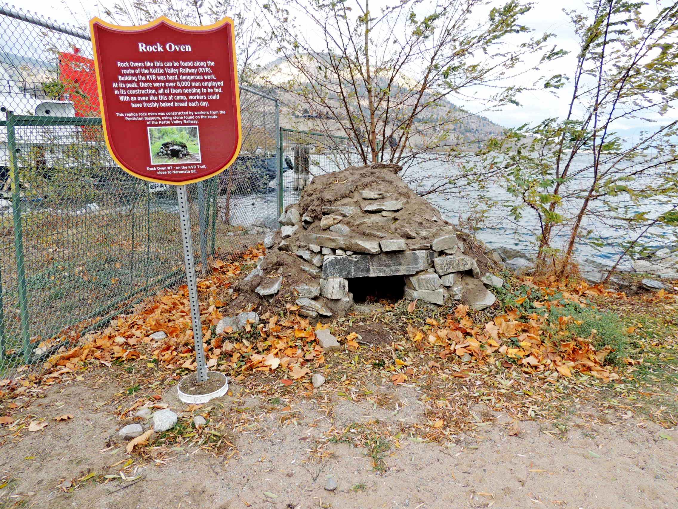
Rock Oven
Rock Ovens like this can be found along the route of the Kettle Valley Railway (KVR). Building the KVR was hard, dangerous work. At its peak, there were over 8,000 men employed in its construction, all of them needing to be fed. With an oven like this at camp, workers could have freshly baked bread each day. This replica rock oven was constructed by workers from the Penticton Museum, using stone found on the route of the Kettle Valley Railway.
The KVR was the work of Andrew McCulloch, Chief Engineer for the Canadian Pacific Railway’s new line in the southern interior of British Columbia…The Kettle Valley Railway. He was hired to build the Coast-to-Kootenay connection when the fear of leaving BC’s mineral wealth vulnerable to exploitation by our neighbours reached its peak. Politicians and corporate leaders including CPR President Thomas Shaughnessy and James J Warren (the first President and originator of the whole idea of the line), stood behind the economic challenge and they moved to protect our province’s resources. The result was the building of 325 miles (500 kilometres) of rail over and through three mountain ranges. It is sad to think that progress (highways and airlines) as well as the challenges of Mother Nature (major snow in the Coquihalla) took their toll – so that by 1964, passenger service had ceased and in 1989, the last freight train rode the rails.
From the KVR Society
![]()
A Brief History of the KVR
Canada welcomed British Columbia and its many resources into Confederation in 1871 with the promise of a railway that would extend from sea to sea. Fourteen years later the Canadian Pacific Railway (CPR) arrived in BC – a little later than planned – but here none the less. Unfortunately the CPR didn’t actually have track that serviced the people of Southern BC where mineral deposits like silver, were being discovered and a fruit industry was blossoming and would become world renown if only it could get to the coast!
In the 1890’s the CPR had extended their service to the South Okanagan constructing the Shuswap & Okanagan Railway from Sicamous on the CPR Mainline through to Okanagan Landing on Okanagan Lake. From that point CPR sternwheeler ships traveled south to Penticton carrying people and freight and making frequent stops along the way.
But this was a long trip to the coast or points east for people living in the South Okanagan and the demand came about for a “Coast-to-Kootenay” connection. Although rails were being laid by the CPR in other parts of BC, it was an American railroader, J.J. Hill who was making headway in the southern part of the province. He was trying to bring a rail line up from Spokane through Oroville and eventually this was accomplished with the acquisition the Vancouver, Victoria and Eastern Railway, a subsidiary of the Great Northern Railroad. It arrived in Keremeos in 1907, and in Hedley and Princeton two years later. The CPR, which was now under the leadership of Thomas Shaughnessy, had created the Columbia & Western Railway through the Crow’s Nest Pass to Midway. They had also put down track for the Nicola, Kamloops and Similkameen Railway.
In 1901 there had been a charter created for the Kettle River Valley Railway (KRVR) which was to connect a mine at Republic and a smelter at Grand Forks. It never materialized but an Ontario lawyer, J.J. Warren had taken over the financial problems of the almost defunct KRVR. He decided to have a chat with the CPR president Shaughnessy about the future of BC’s railways. He knew Sir Thomas “was a man deeply involved with the province and its future… and had personally founded a number of business enterprises in southern BC including the development of the Summerland Development Company which became largely responsible for making Okanagan fruit world famous” (Sanford, 1988). Warren envisioned an alliance of the CPR and the KRVR which represented a subsidiary corporation and could be used to legally expand the rails west from Midway. And so the Kettle Valley Railway (KVR) was born and survey work began in 1910 from Midway to Penticton (Carmi division) and Penticton to Merritt (Princeton division). Shaughnessy felt that the line should also go through the Coquihalla Pass in order for the railway to be successful and work began on this subdivision a year later.
One of the many KVR engineering achievements designed by Andrew McCulloch was the Trout Creek Trestle Bridge in Summerland, which stretched 619 feet across and 238 feet above the Canyon floor. It was and is known as the “infinitesimal” bridge – “incalculable, inestimable, great and fathomless”. It was the highest structure of its kind on the KVR and the third largest of its kind in North America at the time it was built. The Trout Creek Bridge was upgraded in 1927 & 1928 by filling in the Trestle approaches and replacing trestle work with steel girders.
The earlier trains on the KVR were routed from Midway to Spence’s Bridge where they hooked up with the CPR mainline, but after July of 1916 the Coquihalla subdivision was complete and the trains traveled south from Brodie to Hope, meeting up with the CPR mainline there. In time the Coquihalla subdivision proved too much to handle suffering many washouts and snow and rock slides, so in 1959, after a series of abandonment, it was closed and the earlier route adopted once more. We must mention the increasing option of air travel so the KVR found its express service too expensive to maintain. In January, 1964 the final passenger run was made and eight years later the Carmi subdivision from Midway to Penticton was shut down and eventually the tracks were torn up.
While the KVR is said to have been built between 1910-1915 there were Branch lines added to the KVR mainline i.e.: at the end of World War One, a spur was constructed from Princeton to the mines at Copper Mountain; another eight-mile link line was added in 1930, from Penticton to Okanagan Falls. In order to increase fruit shipments to Great Britain during World War Two, this line was extended to Osoyoos. The CPR had officially taken over the KVR operations in 1930 and with the country in the throes of depression and the harsh decline in railway business; they decided to construct these rail lines in order to tap new sources of revenue.
Freight continued to run from Okanagan Falls to Spence’s Bridge until 1989. Much of the track was lifted within a few years except for a sixteen-kilometre stretch from the Trout Creek Bridge to Faulder.
From the KVR Society
![]()
Type of Marker: Cultural

Type of Sign: Historic Site or Building Marker
Describe the parking that is available nearby: Street parking and parking lots nearby
What Agency placed the marker?: S.S. Sicamous Heritage Society
|
Visit Instructions:
When entering a new log for visiting a waymark please provide a picture of your visit to the location and if you have an interesting alternate area or sign photo include that.
Please include any thoughts or historic information about the area that the marker may represent.
Recent Visits/Logs:
| There are no logs for this waymark yet. |
|
|
|
|