Berchtesgaden Alps in 2,5 days, from Golling (AT)
The Berchtesgaden Alps (German: Berchtesgadener Alpen) are a mountain range of the Northern Limestone Alps,
named after the market town of Berchtesgaden located in the centre.
The central part belongs to the Berchtesgadener Land district of southeastern Bavaria, Germany,
while the adjacent area in the north, east and south is part of the Austrian state of Salzburg (Salzburger Land).
Mountains
While the highest mountain of the Berchtesgaden Alps is the Hochkönig (2,941 metres (9,649 ft)) located in the Austrian part, the best known peak is the Watzmann massif,
the third-highest mountain of Germany at 2,713 metres (8,901 ft). The picturesque heart is the glacial Königssee lake with the famous St. Bartholomew's pilgrimage church,
part of the Berchtesgaden National Park established in 1978. The range also comprises glaciers like the Blaueis as well as the Steinernes Meer high karst plateau.
However, now I will invite you for a hike to another impressive part of the mountains in their north-eastern corner - Göllmassive - which offers wonderfull views to mentioned landmarks.
About hike
This hike is trully scenic! Will take you up to limestone mountain ridge of Göllmassive on borderline between Austria and Germany, elevated up to 2500 metres ASL.
We have chosen round-trip from eastern, Austrian side, where we parked our car by thunderous Golling waterfall. It will wait for us here for free over 2 nights.
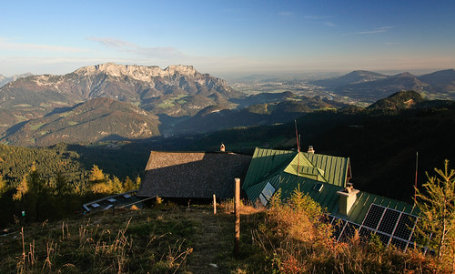
We started on day 1 at noon with visit of waterfall (small fee) and then hiking up through woods and meadows to our first destination - Purtschellerhaus with friendly, family atmosphere, built directly on border between two countries.
Hut offers accomodation, meals and fantastic views to both sides. Ascent took us almost 5 hours, but if you rush, you can do it in 3 and half.
 After beautiful sunset, couple of beers, night in lager (huge room with about 30 beds) and sunrise, we continue climbing to highest point of the mountain ridge and our hike
- Hoher Göll (2522m).
After beautiful sunset, couple of beers, night in lager (huge room with about 30 beds) and sunrise, we continue climbing to highest point of the mountain ridge and our hike
- Hoher Göll (2522m).
Trail is well-marked and safe, but be prepared for feel of heights under your feet!
It is partially secured by fixed ropes, but you dont really need any climbing gear here. It is not even A-grade of via ferrata classification.
After 2-3 hours you will reach the summit plateau with pretty cross on the top.
You can make some pictures, sign summit register and continue south, following the main mountain ridge.
This is the most spectacular part of whole hike.
After another 2-3 hours you will find yourself on Hohes Brett, a flat peak right above saddle Torrener Joch with big chalet Carl-von-Stahl-Haus.
Of course, it offers rooms and meals to many hiker almost all-year long. Hut is open for winter season too.
 For third day you should wake up early! About 20 kms hike with total descent over 2000 metres is waiting for you, with initial climb to pretty peak called Schneibstein.
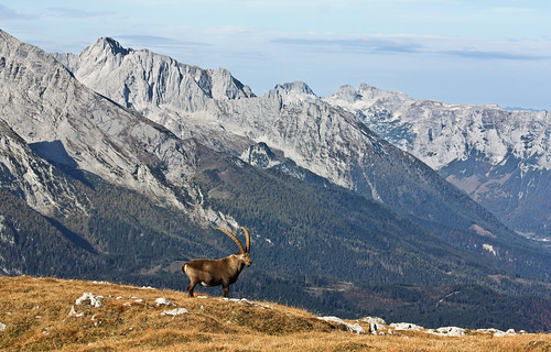
On sunny day you can relax for hours on its grassy hilltop with magnificient views to austrian and german peaks around you.
You will not need a lot of luck to meet herd of capricorns, grazing around you.
After descent to saddle Windscharte, your will follow the trail through Schlumalm valley down to Golling waterfall.
Valley is very long, but picturesque especially in autumn with several steep rocky climbs secured by ladders.
Alternativelly, it is possible to skip the Schneibstein peak and descent directly from Carl-von-Stahl-Haus via Jochalm valley.
Have a nice hike!
Scenic hike facts
| Duration | 2,5 days (4-5 / 7-9 / 9-12 hours of hiking) |
| Terrain characteristics | mainly alpine above 2000 metres, limestone rock and grasses |
| Lenght of the scenic hike | 9 / 9 / 20 kilometres |
| Total Ascent | 1300 / 1300 / 800 metres |
| Total Descent | 50 / 1300 / 2050 metres |
| Highest point | Hoher Göll, 2522m (8274ft) ASL |
| Equipment needed | solid hiking boots to be surefooted, poles, warm clothes, gloves |
| Water availability | available on huts - refill and carry min. 2 litres / person! |
| Season | from May to mid October |
Map
Open the relief-picture below, or click on wandermap.net or wanderreitkarte.de to see detailed map of this area.
Parking / transport
It is safe to leave car on small parking-lot near Golling waterfall (free of charge), even overnight.
We came here by car from Bratislava, using A1 highway it took us 4 hours.
Overnight
Purtschellerhaus (May - mid October) and Carl-von-Stahl-Haus (all year).
Alternatives
Göllmassive can be also climbed from German side, i.e. with usage of cablecar Jennerbahn to Carl-von-Stahl-Haus, which can shorten the trip to 2 days, or even to 1 day if you dont have enough time.
Very popular is connection of hike to Hoher Göll with visit of Kehlsteinhaus, "Eagle’s nest" built by Adolf Hitler’s troops.
Both highlights are connected by exposed mountain trail for 2-3 hours of hike.
There are many many interesting routes and trails to choose from.
Gallery
Visit requirements
Please, log a short story from your hike with few pictures. At minimum, one from Hoher Göll and one from another favourite place on the trail, it is up to you!
Wish you a wonderful hike!
Other references
sources: Wikipedia.org, own visit and photos