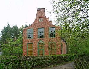
Höhenpunkt Jagdschloß Potsdam, Brandenburg
Posted by: Groundspeak Regular Member Bernd das Brot Team
N 52° 22.545 E 013° 08.795
33U E 373835 N 5804448
Two bechmarks installed in the 19th century by the Prussian Royal Geodetic Institute
Waymark Code: WMKT2T
Location: Brandenburg, Germany
Date Posted: 05/25/2014
Published By:Groundspeak Regular Member KaPsTeam
Views: 9


Hunter's Castle / Jagdschloß
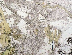

Historical map of the Trail Star

In 1870, the Prussian Royal Geodetic Institute was founded. The Institute was an early leader in the observation and study of earthquakes. The world's first long distant measurement of seismic activities was carried out here in 1889, registering a quake taking place in Japan.

To precisely measure tectonic movements, the institude was looking for a long and absolutely straight line and found it at the Great Trail Star.

This was a hunting resort, founded by Prussian King Frederick William I, consisting of sixteen up to three-mile-long trails, leaving in all directions from the Hunter's Castle, which is locate in the center of the area.

Benchmarks were installed in the center and at the end of all trails around the end of the 19th century and measurements were taken after each registered earthquake.

The benchmarks at the trail ends are lost, but the two marks at the western wall of Hunter's Castle are still existing.

1870 wurde das Königlich-Preußische Geodätische Institut gegründet, das sich in den Folgejahren unter anderem einen Namen in der Erforschung und Beobachtung von Erdbeben machte. 1889 gelang hier die erste Fernaufzeichnung eines Erdbebens (das Beben fand in Japan statt).

Um präzise tektonische Verschiebungen messen zu können, suchte das Institut eine lange, schnurgerade Strecke und wurde am Potsdamer Wegestern fündig. Dieses vom Preußenkönig Friedrich Wilhelm I angelegte Jagdrevier bestand aus 16 bis zu 5 km langen Schneisen, die sternförmig vom Jagdschloss aus in alle Richtungen verliefen.

Gegen Ende des 19. Jahrhunderts wurden an allen Endpunkten der Schneisen sowie im Zentrum Höhenpunkte installiert und nach jedem beobachteten Erdbeben wurden vergleichende Messungen vorgenommen.

Die Höhenpunkte an den Enden der Schneisen sind verlorengegangen, aber die beiden Marken an der Westseite des Jagdschlosses existieren noch heute.

Typ / Type: Höhenpunkt

gemessene Höhe / measured elevation: 40,5 m

GPS-Empfänfger / GPS Device: Garmin etrex 10

Hinweise zum Auffinden vor Ort / How to find the Benchmark:
An der Westseite des Jagdschlosses, an beiden Ecken, etwa 50 cm über der Erde. West side of the building, both corners, 1.5 feet above the ground.


Visit Instructions:
[DE] Um einen Besuch bei einem Waymark in dieser Kategorie zu loggen, muss ein selbsterstelltes Foto des Höhenfestpunkts hochgeladen werden. Ein ausführlicher Log und zusätzliche Bilder sind gerne gesehen.

[EN] To log a visit to a waymark in this category, a self-made photo of the benchmark must be uploaded. A detailed log and additional photos are welcome.
Search for...
Geocaching.com Google Map
Google Maps
MapQuest
Bing Maps
Nearest Waymarks
Nearest German Benchmarks
Nearest Geocaches
Create a scavenger hunt using this waymark as the center point
Recent Visits/Logs:
There are no logs for this waymark yet.