ST CHARLES - St. Charles IL
Posted by: Groundspeak Regular Member geognerd
N 41° 54.421 W 088° 18.909
16T E 390922 N 4640288
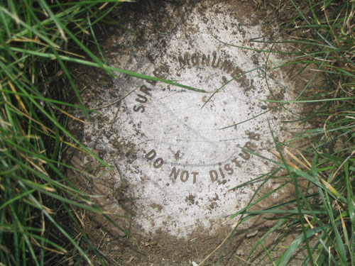
Rod in Moody Park, SW of Downtown St. Charles
Waymark Code: WMHNQ
Location: Illinois, United States
Date Posted: 07/18/2006
Published By:Groundspeak Regular Member Black Dog Trackers
Views: 23

Located near the center of Moody Park. Moody Park is bounded by Moody St on the north, S 4th St on the west, Bowman St on the south, and S 3rd St on the east. This benchmark is near the northwest corner of a chainlink fence surrounding a St. Charles waterworks facility. An orange fiberglass witness post is situated near the benchmark. This is a metal rod covered with a cap. This access point is about two inches below ground level. Some of the surrounding grass and dirt cover the benchmark so I was unable to open the cap.

Condition: Mark found in good condition

Designation: ST CHARLES

Benchmark Agency: National Geodetic Survey

Monumentation type: Metal Rod (under a hinged cover)

County: Kane

USGS 7.5' Topographic Quadrangle Name (optional): Geneva

Special category (optional): Not listed

Find type: Coordinates and/or to-reach information from an online local database were used

NGS PID: AJ3020

Benchmark Agency (if other): Not listed

Monumentation type (if other): Not listed

Special Category (if other): Not listed

Web address of this benchmark's datasheet (optional): Not listed

Local database's URL (optional): Not listed

Visit Instructions:
  1. A closeup photo of the mark taken by you is required.
  2. A 'distant' photo including the mark in the view is highly recommended. Include the compass direction you faced when you took the picture.
Search for...
Geocaching.com Google Map
Google Maps
MapQuest
Bing Maps
Nearest Waymarks
Nearest U.S. Benchmarks
Nearest Geocaches
Create a scavenger hunt using this waymark as the center point
Recent Visits/Logs:
There are no logs for this waymark yet.