
Oregon State Hospital Farm (site) - Salem, Oregon
Posted by:  ddtfamily
N 44° 53.486 W 122° 57.445
10T E 503362 N 4970890
Former farmland used as a work site for state hospital patients
Waymark Code: WMH2XZ
Location: Oregon, United States
Date Posted: 05/13/2013
Views: 2
"The OREGON STATE HOSPITAL FARM (L), 82 m., has a
comfortable group of buildings on an extensive farm tract." (page 477)and in the entry for the Oregon State Hospital it says:
"Twenty-five hundred patients are cared for, many of whom work on the hospital farm a few miles south of the institution." (page 236)
- Oregon: End of the Trail, 1940
While the Oregon State Hospital farm program shut down many decades ago, evidence of it's existence still exists. The GPS coordinates for this waymark are for a driveway into the collection of farm buildings that remain standing, just south of the intersection of Aumsville Highway and Deer Park Drive. Note that there are many "no trespassing signs" posted. The buildings are just north of Santiam Correctional Institution. The main building at Santiam was built in 1946 as an annex for the Oregon State Hospital. In 1960, it was acquired by  Fairview Home (whose main campus was located five miles southwest) and renamed "Prigg Cottage," serving as one of Fairview's 23 residences for the developmentally disabled. By 1977 it had become Department of Corrections property.
The default photo was taken from near the Corban University baseball field, on a hill south of the old farm site. About 1 mile east of this location, at the intersection of Turner Road, Gath Road and Deer Park Drive, is the only remaining signage; a highway sign proclaims "State Hosp. Farm" and directs vehicle traffic east onto Dear Park Drive (44° 52.495'N , 122° 58.164'W).
Note: Click a photo to enlarge

Highway Sign |
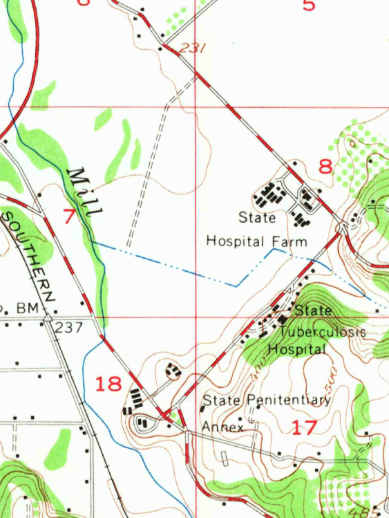
Stayton 15-min USGS map (1957) |

Farm buildings - background (facing east) |

Farm buildings (facing west) |

Farm Buildings (foreground) in front of Santiam Correctional Institution (facing north) |