|
 Early History of St. Simons Island Posted by:  Lat34North Lat34North
N 31° 08.036 W 081° 23.618
17R E 462473 N 3444511
This markers describes the early history of St. Simons Island. The markers is located near the lighthouse at 101 12th Street, Saint Simons Island, GA.
Waymark Code: WMGNW3
Location: Georgia, United States
Date Posted: 03/25/2013
Views: 5
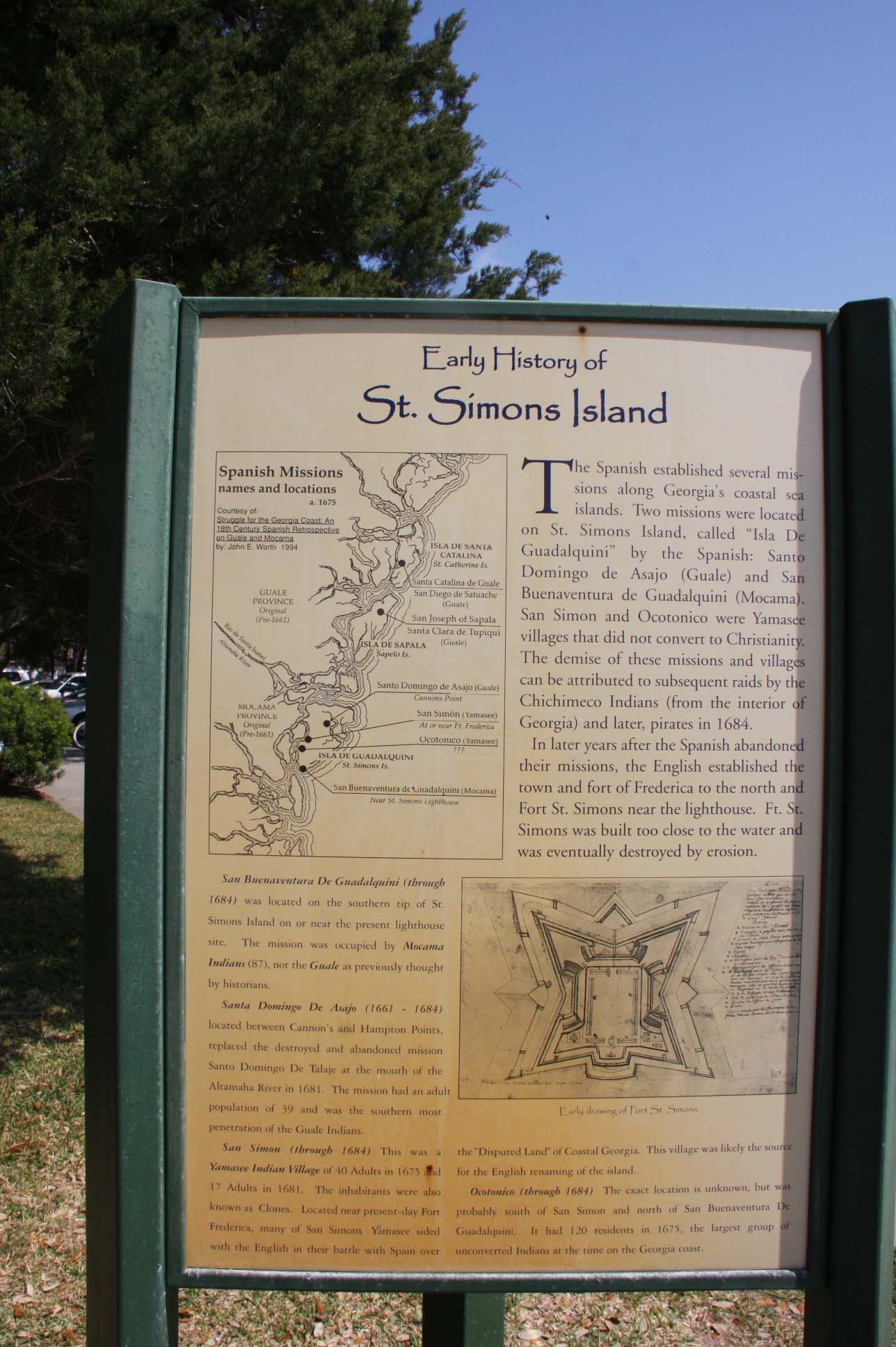
Early History of St. Simons Island
The Spanish established several missions along Georgia's coastal sea islands. Two missions were located on St. Simons Island, called " Isla De Guadalquini" by the Spanish: Santo Domingo de Asajo (Guale) and San Buenaventura de Guadalquini (Mocama). San Simon and Ocotonico were Yamasee villages that did not convert to Christianity. The demise of these missions and villages can be attributed to susequent raids by the Chichimeco Indians ( from the interior of Georgia ) and later, pirates in 1684.
In later years after the Spanish abandoned their missions, the English established the town and fort of Frederica to the north and Fort St. Simons near the lighthouse. Ft. St. Simons was built too close to the water and was eventually destroyed by erosion.
San Buenaventura De Guadalquini (through 1684) was located on the southern tip of St. Simons Island on or near the present lighthouse site. The mission was occupied by Mocama Indians (87), not the Gaule as previously thought by historians.
Santa Domingo De Asajo(1661 - 1684) located between Cannon's and Hampton Points, replaced the destroyed and abandoned mission Santo Domingo De Talaje at the mouth of the Altamaha River in 1681. The mission had an adult population of 39 and San Simon (through 1684) This was a Yamassee Indian Village of 40 adults in 1675 and 17 adults in 1681. The inhabitants were also known as Clones. Located near present-day Fort Frederica, many of San Simons Yamasee sided with the English in their battle with Spain over the "Disputed Land" of Coastal Georgia. This village was likely the source for the English renaming of the island.
Ocotonio (through 1684) The exact location is unknown, but was probably south of San Simon and north of San Buenaventura De Guadalquini. It had 120 residents in 1675, the largest group of unconverted Indians at the time on the Georgia Coast.
Erected by Coastal Georgia Historical Society.
Type of Marker: Park

Marker #: None
Date: None
Sponsor: Coastal Georgia Historical Society
|
Visit Instructions:
Take a picture of the marker, yourself at the marker, your gps at the marker, or anything specific to the text on the marker. And don't forget to enjoy your visit.
|