
Which Way to History? - Salem, Oregon
Posted by:  ddtfamily
N 44° 56.640 W 123° 02.111
10T E 497224 N 4976730
Sign providing an overview of historic sites in downtown Salem
Waymark Code: WMGKAA
Location: Oregon, United States
Date Posted: 03/15/2013
Views: 1
Click a photo to enlarge
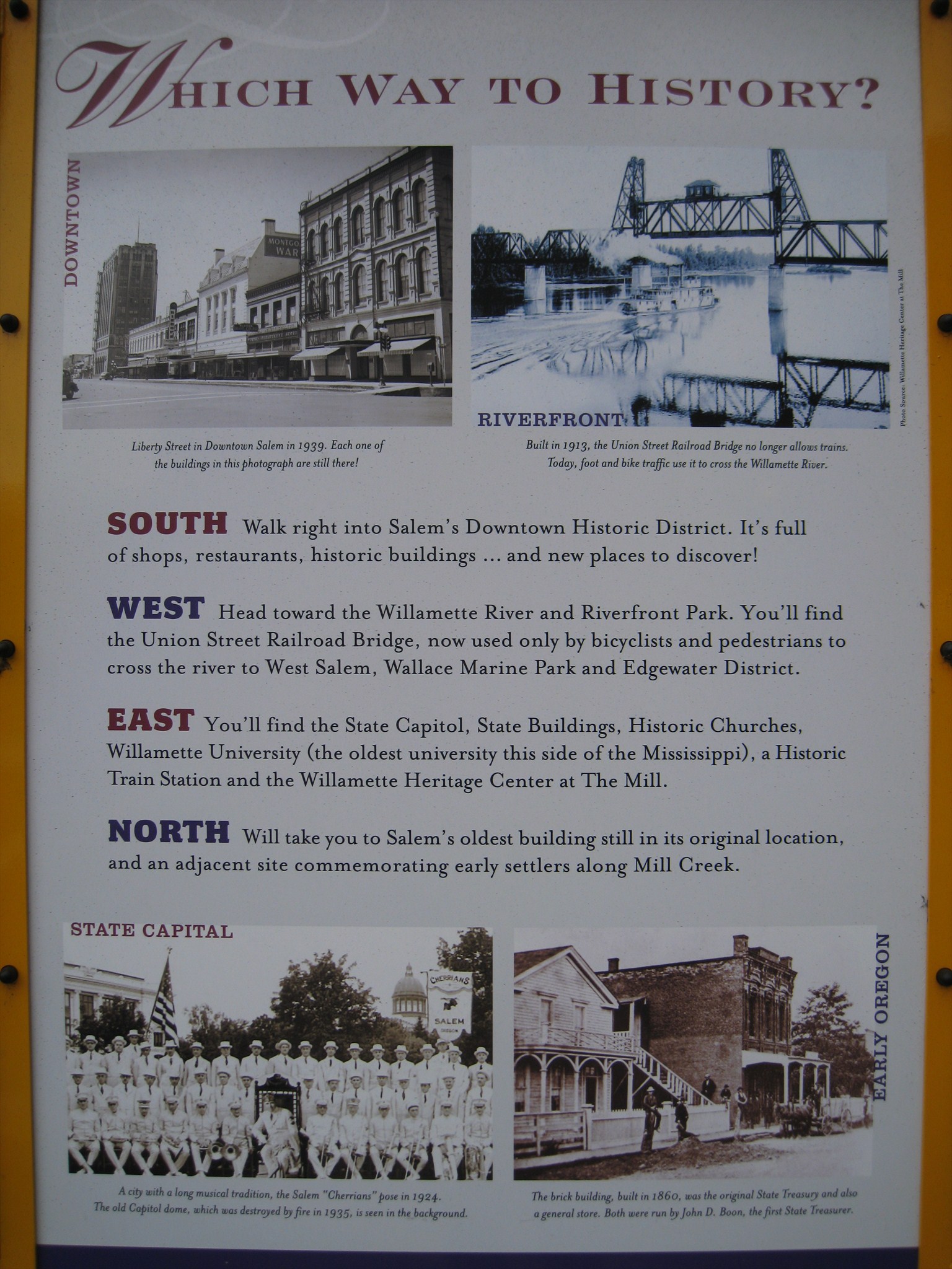
This is one of eight historic markers erected in and around downtown Salem, providing information about points of interest. This particular sign is more general in nature than the others and it describes the sites that can be found in each direction. The marker text reads:
"WHICH WAY TO HISTORY?
South: Walk right into Salem's Downtown Historic District. It's full of shops, restaurants, historic buildings...and new places to discover!
West: Head toward the Willamette River and Riverfront Park. You'll find the Union Street Railroad Bridge, now used only by bicyclists and pedestrians to cross the river to West Salem, Wallace Marine Park and Edgewater District.
East: You'll find the State Capitol, State Buildings, Historic Churches, Willamette University (the oldest university this side of the Mississippi), a Historic Train Station and the Willamette Heritage Center at The Mill.
North: Will take you to Salem's oldest building still in its original location, and an adjacent site commemorating early settlers along Mill Creek."
Marker Photo Captions:
"DOWNTOWN: Liberty Street in Downtown Salem in 1939. Each one of the buildings in this photograph are still there!
RIVERFRONT: Built in 1913, the Union Street Railroad Bridge no longer allows trains. Today, foot and bike traffic use it to cross the Willamette River.
STATE CAPITOL: A city with a long musical tradition, the Salem "Cherrians" pose in 1924. The old Capitol dome, which was destroyed by fire in 1935, is seen in the background.
EARLY OREGON: The brick building, built in 1860, was the original State Treasury and also a general store. Both were run by John D. Boon, the first State Treasurer."
Click a photo to enlarge

The marker is located on the corner of Marion & High streets in front of Kohl's. On the opposite side of this marker is a "You are Here" map to help navigators.
Visit Instructions:
Include your thoughts and observations pertaining to this location and your visit. Provide any additional history that you are aware of that pertains to this location. If the marker commemorates a historic building tell us what it is used for now or share with us the circumstances of an earlier visit to bring this locations history to life.
Please upload a favorite photograph you took of the waymark. Although visiting this waymark in person is the only thing required of you to receive credit for your visit, taking the time to add this information is greatly appreciated.
Be creative.