|
 Shelton Creek - Salem, Oregon Posted by:  ddtfamily ddtfamily
N 44° 56.091 W 123° 02.253
10T E 497037 N 4975713
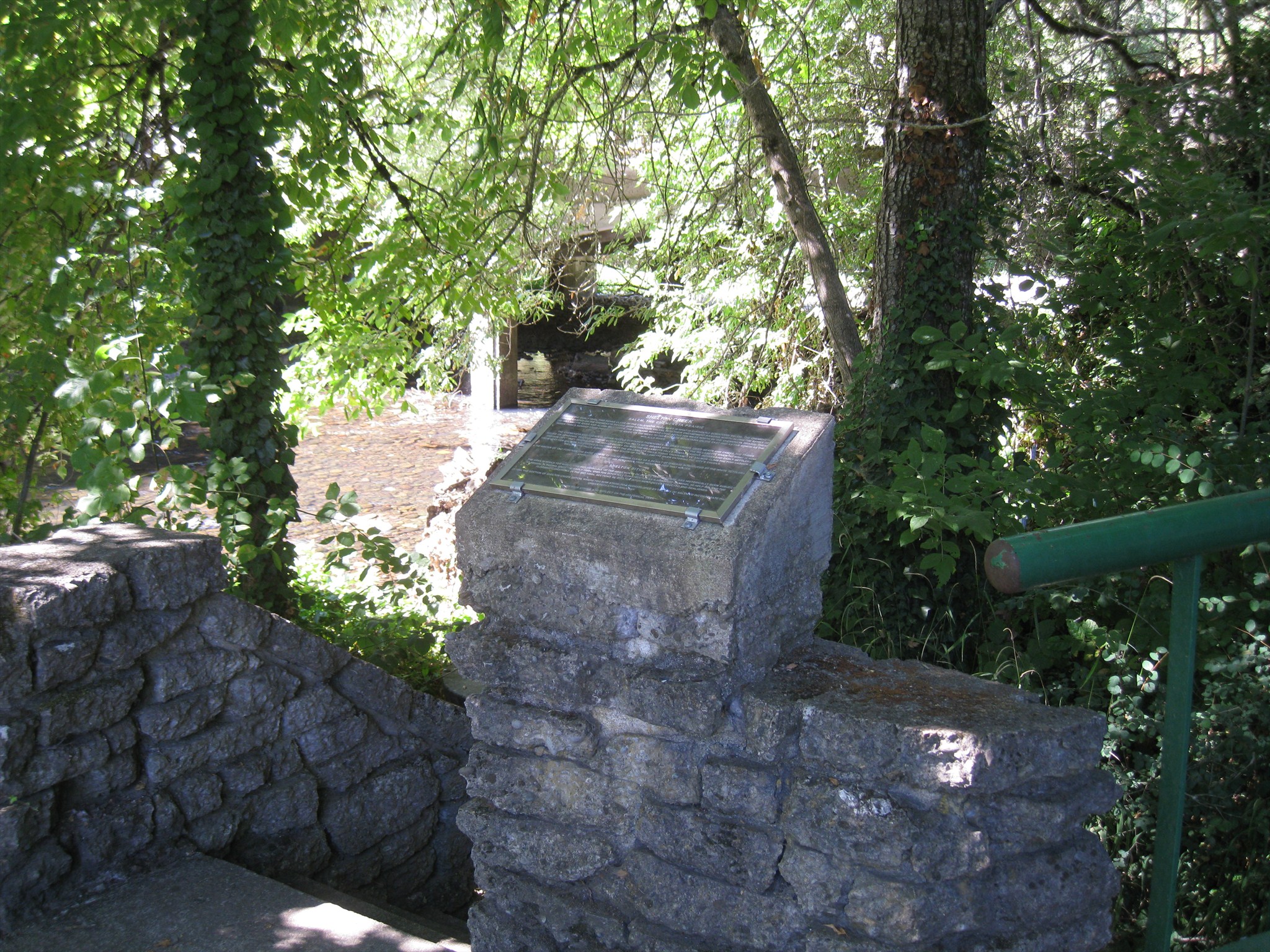
Historical marker on Shelton Creek, beneath the Church Street Bridge
Waymark Code: WMGHZ5
Location: Oregon, United States
Date Posted: 03/10/2013
Views: 2
This historical marker is below street level on a walkway that leads from the north end of the bridge, on the east side, to Shelton Creek, near the corner of Church and Bellevue streets. I never realized this marker existed because it is not visible from the street - the only vantage point where it can be seen is from right in front of it. The marker describes the history of local Native Americans and the problems created in downtown Salem by flooding of Shelton Creek. The marker appears to have been placed by the City of Salem in the mid 1980s. The marker text reads:
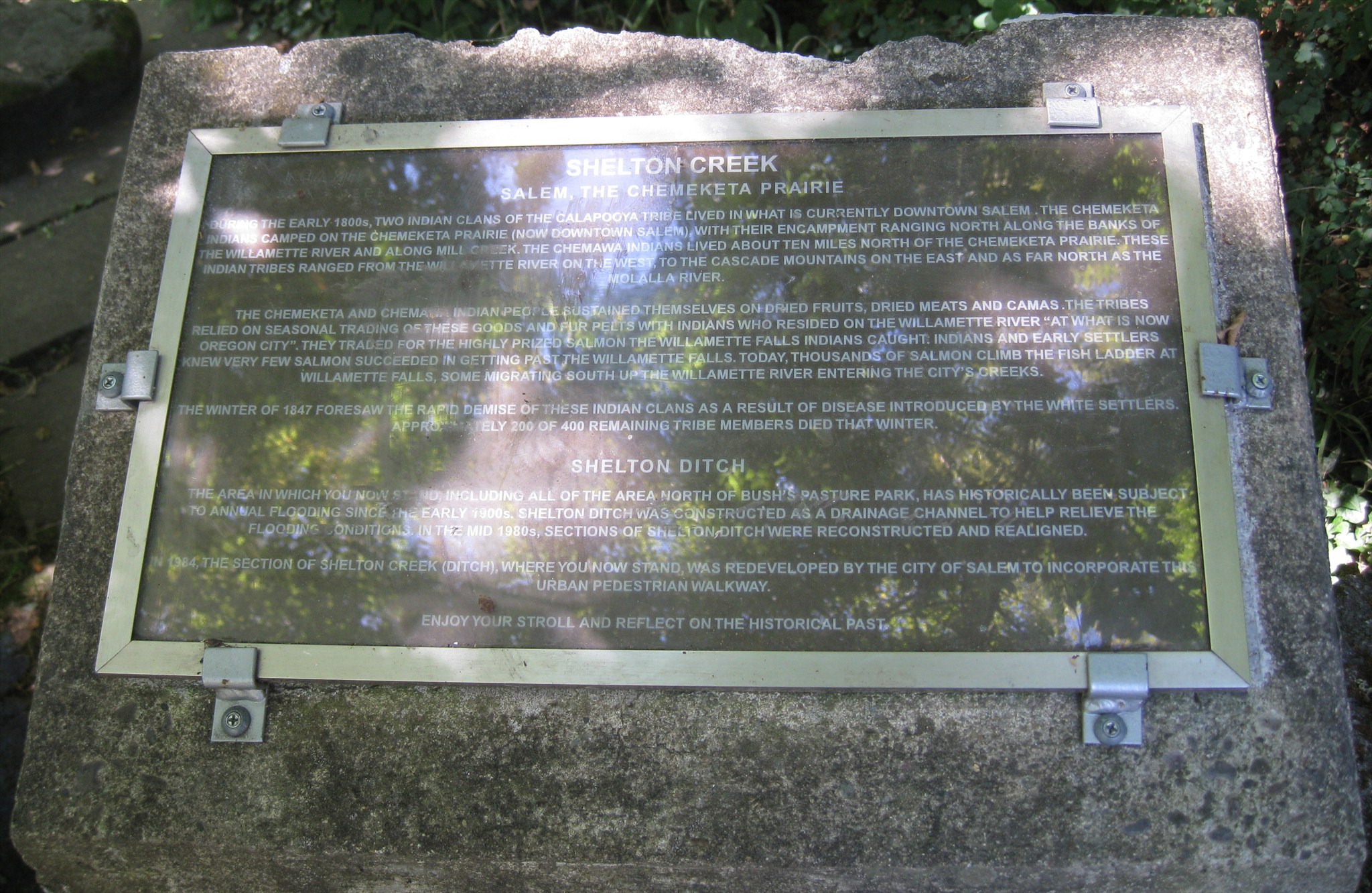
SHELTON CREEK
SALEM, THE CHEMEKETA PRAIRIEDURING THE EARLY 1800s, TWO INDIAN CLANS OF THE CALAPOOYA TRIBE LIVED IN WHAT IS CURRENTLY DOWNTOWN SALEM. THE CHEMEKETA
INDIANS CAMPED ON THE CHEMEKETA PRAIRIE (NOW DOWNTOWN SALEM), WITH THEIR ENCAMPMENT RANGING NORTH ALONG THE BANKS OF
THE WILLAMETTE RIVER AND ALONG MILL CREEK. THE CHEMAWA INDIANS LIVED ABOUT TEN MILES NORTH OF THE CHEMEKETA PRAIRIE. THESE
INDIAN TRIBES RANGED FROM THE WILLAMETTE RIVER ON THE WEST, TO THE CASCADE MOUNTAINS ON THE EAST AND AS FAR NORTH AS THE
MOLALLA RIVER.
THE CHEMEKETA AND CHEMAWA INDIAN PEOPLE SUSTAINED THEMSELVES ON DRIED FRUITS AND CAMAS. THE TRIBES
RELIED ON SEASONAL TRADING OF THESE GOODS AND FUR PELTS WITH INDIANS WHO RESIDED ON THE WILLAMETTE RIVER "AT WHAT IS NOW
OREGON CITY". THEY TRADED FOR THE HIGHLY PRIZED SALMON THE WILLAMETTE FALLS INDIANS CAUGHT. INDIANS AND EARLY SETTLERS
KNEW VERY FEW SALMON SUCCEEDED IN GETTING PAST THE WILLAMETTE FALLS. TODAY, THOUSANDS OF SALMON CLIMB THE FISH LADDER AT
WILLAMETTE FALLS, SOME MIGRATING SOUTH UP THE WILLAMETTE RIVER ENTERING THE CITY'S CREEKS.
THE WINTER OF 1847 FORESAW THE RAPID DEMISE OF THESE INDIAN CLANS AS A RESULT OF DISEASE INTRODUCED BY THE WHITE SETTLERS.
APPROXIMATELY 200 OF 400 REMAINING TRIBE MEMBERS DIED THAT WINTER.
SHELTON DITCH
THE AREA IN WHICH YOU NOW STAND, INCLUDING ALL OF THE AREA NORTH OF BUSH'S PASTURE PARK, HAS HISTORICALLY BEEN SUBJECT
TO ANNUAL FLOODING SINCE THE EARLY 1900s. SHELTON DITCH WAS CONSTRUCTED AS A DRAINAGE CHANNEL TO HELP RELIEVE THE
FLOODING CONDITIONS. IN THE MID 1980s, SECTIONS OF SHELTON DITCH WERE RECONSTRUCTED AND REALIGNED.
IN 1984, THE SECTION OF SHELTON CREEK (DITCH), WHERE YOU NOW STAND, WAS REDEVELOPED BY THE CITY OF SALEM TO INCORPORATE THIS
URBAN PEDESTRIAN WALKWAY.
ENJOY YOUR STROLL AND REFLECT ON THE HISTORICAL PAST.
|
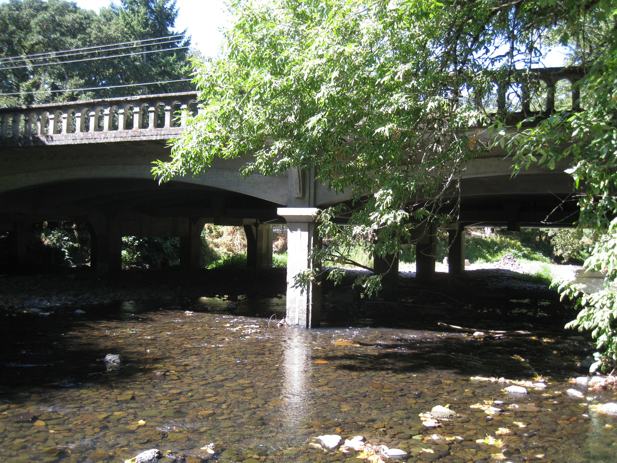
The nearby bridge is a typical beam/girder concrete bridge, about 250 feet in length with 7 main spans. The bridge was built in 1929 and carries Church Street traffic over Shelton Creek/Ditch.
Click a photo to enlarge
Historic Topic: Pioneer

Group Responsible for placement: City Government
Marker Type: City
Region: Willamette Valley
County: Marion
State of Oregon Historical Marker "Beaver Board": Not listed
Web link to additional information: Not listed
|
Visit Instructions:
Include your thoughts and observations pertaining to this location and your visit. Provide any additional history that you are aware of that pertains to this location. If the marker commemorates a historic building tell us what it is used for now or share with us the circumstances of an earlier visit to bring this locations history to life.
Please upload a favorite photograph you took of the waymark. Although visiting this waymark in person is the only thing required of you to receive credit for your visit, taking the time to add this information is greatly appreciated.
Be creative.
Recent Visits/Logs:
| There are no logs for this waymark yet. |
|
|
|
|