|
 Shoupade Park - Cobb Co., GA Posted by:  Lat34North Lat34North
N 33° 50.201 W 084° 29.541
16S E 732046 N 3746876
Within Shoupade Park are the remains of the Civil War fortifications designed by Brig. Gen. Francis Shoup near the Chattahoochee River during the Atlanta Campaign. Gen. Sherman called it “the strongest field fortification he'd ever seen”.
Waymark Code: WMGD7N
Location: Georgia, United States
Date Posted: 02/17/2013
Views: 1
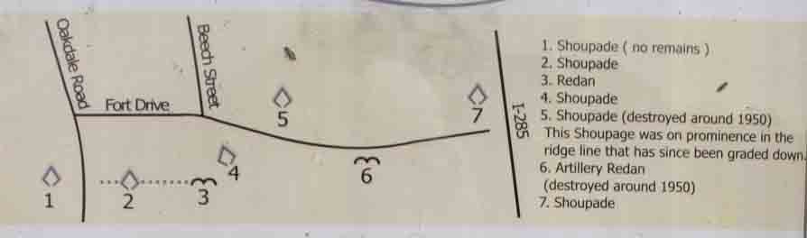
Map of Shoupade Park
Shoupade Park
Within this park is the remnant of the unique fortification known as Johnston's River line. In mid June 1864, the Confederate Army of Tennessee under General Joseph E. Johnston was fighting in Central Cobb County and about the withdrawal to the Kennesaw Mountain line. Johnston had been opposing the federal forces under Major General William T. Sherman since the Federals began their advance in early May near Ringgold, 90 miles north of here. Battles had been fought at Resaca, Rome, Adairsville, New Hope Church, Pickett's Mill, and Dallas. Although the Federals had been unable to decisively defeat the Confederates, Johnston ultimately continued to withdrawal his forces towards Atlanta after each battle.
Brigadier General Francis Shoup, chief of artillery for the Confederate Army, approached General Johnston on 18 June 1864. Anticipating the Confederates would eventually be forced from the Kennesaw Mountain Line, Shoup proposed that he prepare a defensive line along the Chattahoochee River, to include the most important rail and road crossing, near where Atlanta Road crosses the river today (about two miles southeast of here). Shoup envisioned a line strong enough that it could be heldd by part of the Confederate Army, while the rest could be used to attack any river crossing by the federals. Johnston agreed to Shoup's proposal.
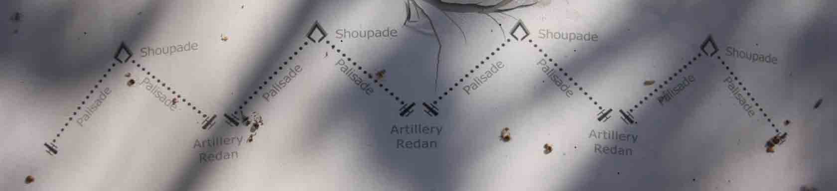
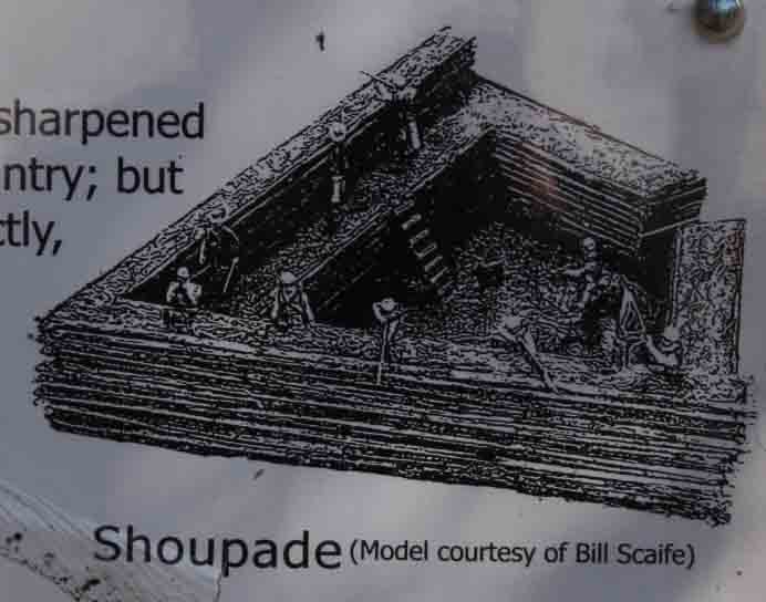
Confederate engineering officers went to slave-owners in the Atlanta area and conscripted slaves to build the defenses. Rather than construct the usual fortifications, Shoup designed a defensive line that was unique. From above, it resembled the cutting edge of a saw blade. At the point of each saw tooth was an arrowhead-shaped fort that could hold about 80 riflemen. The trenches connecting these forts receding towards the river until they met at an angle. At the angle, the slaves built a smaller work - called a redan - that held two canons. Shoup envisioned that any Federals attacking this line would be driven away from the forts by rifle fire and into the spaces between the forts, where artillery fire would sweep the field.
Shoup's original line was about six miles long, with the right resting on the Chattahoochee River north of Montgomery Ferry and the left north of Mayson-Turner Ferry. This line included 35 of the unique, arrowhead-shaped forts. When General Johnston inspected the earthworks, he ordered that the left be extended to the south of the Mason-Turner Ferry. This lengthened the line to about seven miles, but the hasty construction of the extension allowed for only one more arrowhead-shaped fort and an anchor fort at the end, the rest of the line being a conventional trench. The entire set of fortifications was subsequently known as Johnston's River Line.
The Confederates held the Kennesaw Mountain line until early on 3 July in the interim Smyrna line until late on 4 July. When the Confederate troops marched into Johnston's River Line on 5 July, many of them were skeptical of the [?unique?] structures, and some men even began to tear them down; but Major General Patrick Cleburne, perhaps the most respected division commander in the [?Army?] : pronounced the design to be excellent, and the destruction ceased.
The design was complemented by the opposing commander, Major General William T. Sherman. From a hill above [?Vining?] Station on the morning of 5 July, Sherman saw him in the Confederate line through binoculars. He called it the strongest field fortification he'd ever seen. Sherman deployed part of his force in opposing line, but he did not plan to attack the Confederate defense instead, Sherman sent troops down river to feign a crossing there and other troops up river to find a place to cross the Chattahoochee. The federals established the first river crossing on 8 July near Sope Creek and two more bridgeheads on 9 July at Roswell and at Power's Ferry. Again flanked out of a position, Johnston withdrew his army from the River Line on the night of 9-10 July. A week later, President Davis removed Johnston from command.
This park is made possible by: The Cobb County Board of Commissioners, River Line Historic Area, Oakdale Community Association, Pulite Homes, Easlan Capital, & the Georgia Battlefield Association.
The park is located on the east side of Oakdale Rd. between Dunagan Dr. and Fort Dr., Smyrna, GA. There are four interpretative signs in the park and the remains of a section of the earthworks.
For more information on the history of Johnston's River Line:
Historic Markers
On-line:
Books:
The Chattahoochee River Line
An American Maginot
by William R. Scaife and William E. Erquitt
©1992
ISBN: 0-9619508-5-4
Hells´s Broke Loose in Georgia
Survival in a Civil War Regiment
by Scott Walker
©2005
ISBN: 978-0-8203-2605-04
Type of Marker: Fort

Marker #: None
Date: unknown
Sponsor: The Cobb County Board of Commissioners, River Line Historic Area, Oakdale Community Association, Pulite Homes, Easlan Capital, & the Georgia Battlefield Association
|
Visit Instructions:
Take a picture of the marker, yourself at the marker, your gps at the marker, or anything specific to the text on the marker. And don't forget to enjoy your visit.
|