
Dead Man's Curve Marker - Perry County, Pennsylvania
N 40° 17.363 W 077° 27.747
18T E 290685 N 4462785
This is a site of a fatal accident of a CCC member in 1934. It is located on Bower Mountain Road within the Tuscarora State Forest (Toboyne Township, Perry County, Pennsylvania) Note: Access is seasonal due to road conditions
Waymark Code: WMFNTN
Location: Pennsylvania, United States
Date Posted: 11/10/2012
Views: 5
Dead Man's Curve Marker - Perry County, Pennsylvania
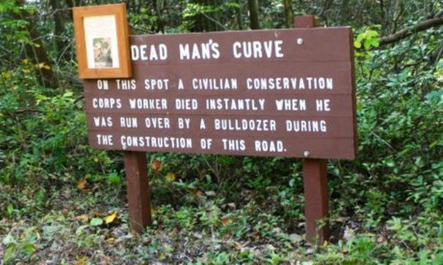
This roadside memorial marker is dedicated to a former CCC enrollee, Henry Hamerski. Henry Hamerski made the fateful decision on August 20, 1934 not to sleep and joined the work crew that morning. During a rest period, he laid down along the road to take a nap. He chose a spot which recently had been traversed by a bulldozer that made its way up one side of the road and down the other.
The operator, for whatever reason, decided to descend the road on the same side he had ascended, which was not the normal practice, and one of the cleats of the bulldozer’s tread hit Henry Hamerski in the head as he slept.
A stone marker was later placed by the Company of the CCC in which Hamerski served. Recently, the Tuscarora State Forest District placed a marker and photo frame of the individual on the seasonally-closed Bower Mountain Road in Toboyne Township, Perry County.
Hamerski was a native of Latrobe, Westmoreland County, and is interred in Saint Mary's cemetery in Latrobe.