
APPLEGATE TRAIL - QUITE ROCKY Historical 'T' Marker - Siskiyou County, CA
N 41° 52.399 W 121° 41.962
10T E 607929 N 4636528
This historical 'T' marker is located just off of Dorris Brownell Rd in Siskiyou County, CA.
Waymark Code: WMFNC3
Location: California, United States
Date Posted: 11/08/2012
Views: 1
This historical marker is part of a series of historical 'T' markers by the Trails West Historical Group who's mission is to place 'T' markers along immigrant trails leading west into Nevada, California and Oregon. The group also sells trail books for followers who are interested in re-enacting various immigrant trails from beginning to end.
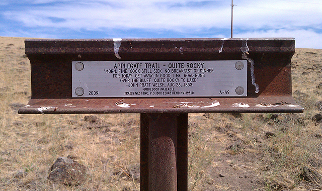
The Applegate Trail 'T' marker text reads:
APPLEGATE TRAIL - QUITE ROCKY
"MORN. FINE. COOK STILL SICK NO BREAKFAST OR DINNER
FOR TODAY. GET AWAY IN GOOD TIME ROAD RUNS
OVER THE BLUFF QUITE ROCKY TO LAKE"
-JOHN PRATT WELSH, AUG 26, 1853
GUIDEBOOK AVAILABLE
2009 ---- TRAILS WEST INC. P.O. BOX 12045 RENO NV 89510 ---- A-49
This 'T' marker is one of many I have discovered in California and Oregon. The goal is to hopefully waymark more of these historical markers over time as I come across them. There is also another great website run by the Oregon-California Trails Organization (OCTA) which includes an interactive tour of all the emigrant trails that led into Utah, Nevada, California and Oregon from the mid 1800s. Click here to learn more history about these wonderful historic trails.
This particular section of the Applegate Trail is heading north into Oregon along the Lower Klamath Lake Wildlife Refuge. Parts of Dorris Brownell Rd make up this historic Applegate Trail of yesteryear.