
APPLEGATE TRAIL - CLAMMETT LAKE Historical Marker - Siskiyou County, CA
N 41° 59.454 W 121° 35.734
10T E 616329 N 4649719
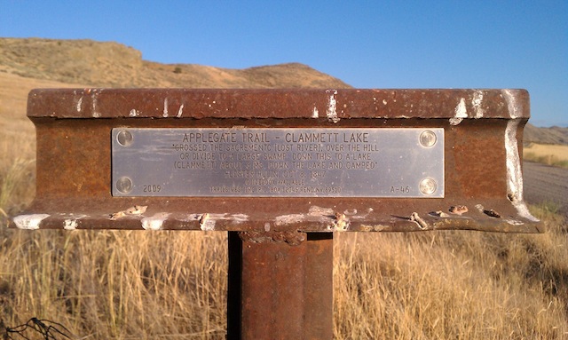
This historical 'T' marker is located just off of Dorris Brownell Rd a few miles south of Merrill, OR and is part of the Emigrant Trails West series of 'T' markers.
Waymark Code: WMF3GK
Location: California, United States
Date Posted: 08/16/2012
Views: 2
This historical marker is part of a series of historical 'T' markers by the Trails West Historical Group who's mission is to place 'T' markers along immigrant trails leading west into California and Oregon. The group also sells trail books for followers who are interested in re-enacting various immigrant trails from beginning to end.
The Applegate Trail 'T' marker text reads:
APPLEGATE TRAIL - CLAMMETT LAKE
"CROSSED THE SACREMENTO [LOST RIVER], OVER THE HILL
OR DIVIDE TO A LARGE SWAMP DOWN THIS TO A LAKE
(CLAMMETT) ABOUT 3 MS, DOWN THE LAKE AND CAMPED"
-LESTER HULIN, OCT 8, 1847
GUIDEBOOK AVAILABLE
2009 ---- TRAILS WEST INC. P.O. BOX 12045 RENO NV 89510 ---- A-46
It should be noted that the name of Clammett Lake is actually referencing 'Klamath Lake', as Lester Hulin spelled it incorrectly in his pioneer logs. This 'T' marker is one of many along the Applegate Trail in Nevada, California and Oregon. The goal is to hopefully waymark more of these historical markers over time.