
The 5th Corps, 3rd Division, 1st Brigade was also known as McCandless’ Brigade. During the battle of Gettysburg, it served as a member of Crawford’s Division in the Fifth Corps, Army of the Potomac. The brigade was commanded by Colonel William McCandless (September 29, 1834 – June 17, 1884), an officer in the Union Army during the American Civil War, commanding a regiment and then a brigade in the Pennsylvania Reserve Division. In May 1863, the Reserves, then commanded by Samuel Crawford, returned to the Army of the Potomac and became the 3rd Division of the V Corps. McCandless retained command of the 1st Brigade, and was active in the Battle of Gettysburg. On the second day of the battle, McCandless moved to the army’s left and deployed his men in two lines, together with the 93rd Pennsylvania Infantry of Frank Wheaton’s brigade, at the foot of Little Round Top. McCandless’ brigade, under immediate supervision by Crawford, launched a counterattack against the Confederates, mostly from William T. Wofford’s command, across Plum Run Valley and up slope to the edge of the Wheatfield on July 2, 1863. (Wofford had been ordered to withdraw and did not resist as fiercely as he desired.) McCandless’s brigade held its position to the end of the battle. Then it advanced late on July 3, gathering up stragglers from the Confederate withdrawal. McCandless returned to Philadelphia and resumed his civilian career. He died on June 17, 1884.
The McCandless' Brigade - US Brigade Tablet is located along Ayers Avenue just before the road begins to bend at the northern part of an S-shaped turn. The marker is on the left or southeast of the road if traveling southwest along the road. To the northeast of this position is Wheatfield Road (T-intersection) and to the south, the Sickles Road intersection, the monument about half way between the two. There is also a large patch of woods (Rose Grove?) which begins (or ends) at this monument location (northeastern part of the woods). This site is also the southeast border of the Wheatfield, which border is defined on its west side by Ayers Road. When I visited the field was overgrown with tall grass, wildflowers and ticks making it difficult to walk inside and visit the several monuments and position markers. The monument faces northwest looking across the road, which also runs northwest. 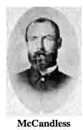 Parking is available at small, cutout shoulders along the road, some wide, some narrow. Be sure to stay off the grass or you will be tickete by park police. I visited this monument on Thursday, July 5, 2012 at 1:02 P.M. I was at an elevation of 540 feet, ASL. I used a Canon PowerShot 14.1 Megapixel, SX210 IS digital camera for the photos.
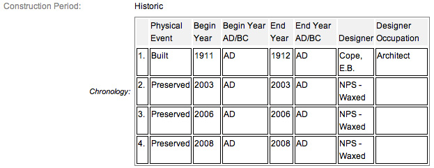
The monument work was done under the direction of the Gettysburg National Park Commission (established by the United States Department of War), after they took over the administration of the park from the Gettysburg Battlefield Memorial Association (whose funds had expired) on March 3, 1893, and whose stewardship was then transferred to the National Park Service in 1933) SOURCE. According to the NRHP narrative, this monument was built in 1911 but finished in 1912, which according to my experience is questionable. I can't resolve if the 1912 date represents a completion of the physical construction of the tablet or an installation date. Other sources have it at 1910 & 1912. I don't know if anyone actually kept exact records of when these things were installed, so as a default, I will use 1910.
Draw the Sword, with descriptive help from the NPS site, offers the following description: Monolith consisting of polished smooth sea-green granite pedestal with a square base. Base tapers to a smaller dimension at the tablet. On each pedestal is mounted a bronze inscription tablet describing the movements and actions of the unit. There is also a maltese cross atop of the tablet, before the inscription begins. This is the symbol of the V Corps.
One of 74 (or 75 depending who you listen to) Union brigade monuments erected at Gettysburg by the United States War Department to describe the movements and itinerary of each Union brigade of the Army of the Potomac. The monuments were designed by E.B. Cope. Many of the inscription tablets were made of bronze melted down from Civil War cannons. The inscription on this tablet reads:
 Army of the Potomac
Fifth Corps Third Division
First Brigade
Col. William McCandless
30th. 31st. 35th. 42d. Pennsylvania Infantry
(1st. (9 Cos.) 2d. 6th. 13th. Reserves)
July 2 Moved with the Division from the Baltimore Pike near Rock Creek late in the day to Little Round Top north of the Wheatfield Road. After sunset formed line to cover the retiring of First and Second Brigades Second Division and supported by Third Brigade Third Division Sixth corps charged the advancing Confederates and forced them down the hill and across into the Wheatfield. The Brigade remained at a stone wall in rear of the Wheatfield. Col. C.F. Taylor commanding 13th Penna. Reserves fell in the advance.
July 3 Advanced through the Wheatfield into the woods beyond supported by Third Brigade Third Division Sixth Corps and changing front swept southward through the woods west and south of the Wheatfield encountering a portion of Brig. Gen. Benning's Brigade and capturing about 200 prisoners and the colors of 15th Georgia. The Confederates retired to the crest of ridge from which they advanced the previous day. In this movement one 10 pounder Parrott was recovered and about 3,000 small arms were gathered from the field.
Casualties. Killed 2 officers 18 men. Wounded 14 officers 118 men. Captured or missing 3 men. Total 155.
There are hundreds of non-sculpted monumentation for the various Confederate States & Union units which fought at Gettysburg. There are about 10 different variations of tablets, markers & monoliths by my reckoning. Six designs represent brigade (2), division (2), corps (2), & army headquarters (2), each different in a subtle way so as to distinguish between armies. Battalion/battery/advance position markers & regimental monuments for U.S. Regulars & Confederate have their own distinct design (2), bringing the total to 10 designs at the battlefield. The bronze tablets were created by Albert Russell & Sons Co. of Newburyport, Mass. The granite bases which accompany the various tablets were created by the Van Amringe Company from Boston, Mass. The cast iron tablets were manufactured by Calvin Gilbert. The 1910 Gettysburg Commission report lists the awarded contracts to these companies (not Gilbert) for the tablets. All of these tablets were designed by architect Colonel Emmor Bradley Cope (July 23, 1834 - May 28, 1927). He designed pretty much every tablet for both the Union & Rebel armies, each one distinct, w/ several different varieties. He is buried in Evergreen Cemetery  in Gettysburg, as well he should be as this park and most of the things seen here today were designed by him and as such, are his legacy. These monuments were erected just after the turn of the century during the first & beginning of the second decade of the 20th century. Each one has since been preserved or restored at least twice since the turn of the 21st century. The plaques & tablets were erected by the Gettysburg Park Commission (established by the War Dept.). The Gettysburg Park Commission is also referred to as the Gettysburg National Military Park Commission or the Gettysburg National Park Commission, to clear up any confusions, especially my own.
On October 1, 1898, the Gettysburg National Park Commission in a letter to the Secretary of War set gave recommendations for continuing the task of organizing & progressing the work of the Gettysburg National Military Park. Every November they wrote their annual report which outlined the work of the GNPC for that year. The following is an excerpt from that report relevant to this waymark. The link at the end of the paragraph will take you to the entire report. The method of marking the positions of troops on this field, as approved by the War Department, is to place the principal tablet or monument of each command at the position occupied by the command in the main line of battle, and to mark the several important positions subsequently reached by each command in the course of the battle by subordinate and ancillary tablets, with appropriate brief inscriptions giving interesting details and occurrences and noting the day and hour as nearly as possible. SOURCE
Most of the Commission reports have been digitized and can be found HERE. The initial 1893 report up to & including 1921 can be found here. 1922 to 1926 are missing & have yet to be discovered. The years 1927 to 1933 were discovered in 1996 and are also included. To my knowledge this is the most comprehensive list of documents that illustrated the development and formation of the park.
Information about these specific types of monuments:
BRIGADE HEADQUARTERS MARKERS (FOR UNION & CONFEDERATE TABLETS)
Brigade Headquarters (and Confederate artillery battalions, equivalent to Union artillery brigades) are bronze tablets mounted at an angle on a stone pedestal. They are the most numerous headquarters at Gettysburg, with over 70 Union and over 60 Confederate examples on the field. Union headquarters are marked with their corps or service branch symbol (like a cross, clover or crescent moon), while Confederate headquarters are simply labeled "C.S.A.". There are seventy-four brigade markers at Gettysburg honoring the AOP’s various brigades. (Other sources say there are 75). They were built by Albert Russell & Sons Co. of Newburyport, Massachusetts and Charles Kappes. The pedestals consist of sea-green granite with a square 36” x 36” base; they weigh 3500 pounds. On each pedestal is mounted a bronze tablet with rounded corners weighing 300 pounds. There are sixty-four brigade markers honoring the Army of North Virginia's various brigades. They were built by Van Amringe Granite Company (pedestals), Albert Russell & Sons Co., Newburyport, Mass (tablets) and Charles Kappes (foundations). The last was completed in December 1910. The 1910 date is disputed by other sites listing the end dates as 1912. The monuments consist of red circular Maine granite bases 34 1/2 inches diameter and weighing 3,000 pounds. On each base is mounted a 300 pound bronze tablet. SOURCE & SOURCE
The McCandless' Brigade - US Brigade Tablet is a contributing feature to the Gettysburg Nat'l Military Park H.D. which is nationally significant under NR Criteria A, B, C & D. Areas of Significance: Military, Politics/Gov't, Landscape Architecture, Conservation, Archeology-Historic. Period of Significance: 1863-1938. The monument is designated as structure no. MN492.
From the Nomination Form:
1 of 75 Civil War US Brigade Tablets in Park. Records movement & itinerary of McCandless' Brigade during the Battle of Gettysburg, July 1-3, 1863.
Short Physical Description:
Bronze inscription tablet, 4”0’ x 3’8”, attached to slant face of polished sea green granite monolith. 3’0” squared base of monument tapers to a smaller dimension at the tablet. All 5’4” H.
Long Physical Description:
Located on E side of Ayres Avenue, the Wheatfield.
My Sources
1. NRHP Nomination Form
2. Stone Sentinels
3. Virtual Gettysburg
4. Draw the Sword
5. Historical Marker Database
6. Wikipedia
7. Find a Grave