Welcome to Mt McLoughlin!
The following text is taken from the Oregon Trails
website:
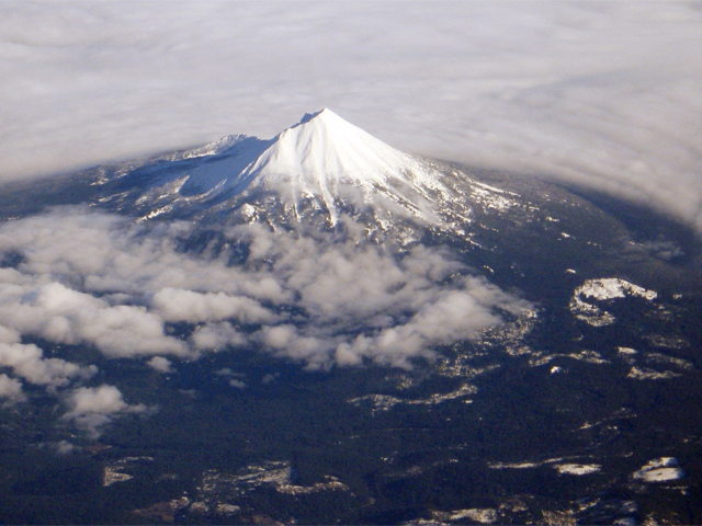
Mt. McLoughlin rises 9,495 feet above sea level. Although its eastern base is in Klamath County and the Winema National Forest, most of it (including the summit) are in Jackson County and the Rogue River National Forest. Mt. McLoughlin covers an area of over 20 square miles and it comprises an estimated volume of about 4 cubic miles. It is the highest peak in southern Oregon, and the highest point in the Cascade Range between the Three Sisters and Mt. Shasta.
After leaving the parking lot, you pass through a forest composed largely of Shasta red fir and mountain hemlock, with scattered lodgepole pine and other trees; manzanita and other shrubs form the under story. As you climb above the forested slopes, you see only the hardy whitebark pine -- a stunted, subalpine species. Although deer, elk and bear occur on the mountain's lower slopes, most of the animals you're likely to see are smaller: Clark's nutcracker (a grey/black/white bird), golden-mantled ground squirrel (common at the summit), and if you're lucky, pine marten (a shy member of the weasel family).
The 5.5-mile long trail to the summit winds through rocky terrain. In many places it is difficult to see and follow. After it leaves the Pacific Crest Trail behind (at a point about a mile from the parking lot), the trail ascends through a boulder-strewn forest; watch for blazed trees. Above timberline piled-up rock cairns mark the route to the ridge-top summit route...along the ridge, the trail is marked by the old Forest Service telephone poles which lead to the top.
Due to steep slopes, poor footing and coarse bare rock, horses are not recommended for the Mt. McLoughlin Trail above its junction with the Pacific Crest Trail.
Mt. McLoughlin is located within Sky Lakes Wilderness. Motorized vehicles and bicycles are prohibited within the Wilderness and groups sizes are limited to 12 people or less. Please observe the "pack it out" ethic (and perhaps you might even pick up other people's litter as you come down)...take only pictures, leave only footprints.
From the Wikipedia
website:
Mount McLoughlin is a steep-sided lava cone built on top of a shield volcano [5] in the Cascade Range of southern Oregon and within the Sky Lakes Wilderness area. It is one of the volcanic peaks in the Cascade Volcanic Arc. The mountain is north of Mount Shasta, south of Crater Lake, and west of Upper Klamath Lake. It was named around 1838 after John McLoughlin, a Chief Factor for the Hudson's Bay Company.[6] Mount McLoughlin has been known by a number of different names over the years, including Mount Pitt (after the Pit River), Big Butte, M'laiksini Yaina (Klamath Indians), Malsi (Takelma Indians), Mount Shasty (although this name was applied to Mount Shasta to the south by the 1841 Wilkes Expedition), and Snowy Butte.
The Pacific Crest Trail skirts the eastern and northern sides and also accesses the only trail to the summit. On a clear day, the Sky Lakes Wilderness area, Crater Lake, Rogue Valley, and Mount Shasta are visible from the summit.
The best time to climb Mt McLoughlin is between late June through September, depending on the amount of snow that accumulates at the summit. There is a parking lot with restrooms and a $5 per day parking/visitor fee, which is closely monitored by the Forest Service employees. Plan on an all day hike and it would be highly suggested to leave earlier in the morning to give yourself plenty of time to hike to the summit and back, it is a total of 10-11 miles and not for the faint-of-heart hiker. BRING PLENTY OF WATER and MOSQUITO REPELLANT!
*Waymark owner note* I have been to the summit of Mt McLoughlin four times in the past seven years and have yet to experience a clear blue sky since there are always forest fires going on during the summer months. Also, there are two benchmarks that have been destroyed at the summit: a fire lookout tower that burned down in the late 80s/ early 90s and a benchmark disk imbedded in a boulder that was pried out with only the shaft and concrete epoxy remaining as evidence of its existence. The link below will bring you to the Geocaching.com website to log the Mt McLoughlin lookout tower benchmark if you so desire:
Lookout Tower
The following link is another neat website that has pictures of the lookout towers over the years (it was rebuilt in 1927). The only remnants of the lookout tower that remain are a partial corner of the tower foundation.
Lookout Tower pictures