|
 Falls of Hills Creek Scenic Area - Monongahela National Forest - Hillsboro, West Virginia
N 38° 10.680 W 080° 20.323
17S E 557919 N 4225771
The 114-acre Falls of Hills Creek Scenic Area is located along State Routes 39 and 55 in the Monongahela National Forest in Pocahontas County, West Virginia.
Waymark Code: WMER5H
Location: West Virginia, United States
Date Posted: 06/30/2012
Views: 3
Falls of Hills Creek Scenic Area - Monongahela National Forest - Hillsboro, West Virginia
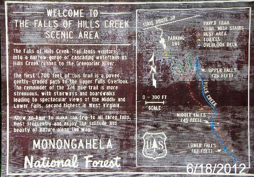
Tucked away in a narrow gorge just off the Highland Scenic Highway is a hidden treasure known as the Falls of Hills Creek Scenic Area. This
popular 114 acre area contains three waterfalls - 25 feet, 45 feet, and 63 feet. The lower falls, at 63 feet, is the second highest waterfall in West Virginia. A three quarter mile trail leads visitors to spectacular views of the three waterfalls as Hills Creek descends 220 feet between the upper and lower falls. The first 1700 feet of trail is a paved, wheelchair accessible path to the upper falls
viewing platform. The remainder of the trail is more strenuous with stairways and boardwalks leading to the lower falls. There are 382 stair steps to the lower falls.
Geology
Here in the Hills Creek area, there are exposed layers of hard sandstone rock over very soft layers of red shale. Water running down these alternating hard and soft layers began to cut rapidly in the soft shales and much slower in the hard sandstone. As a result, the shale was eroded from underneath the sandstone causing blocks of stone to break off when the shale no longer supported them.
Wildflowers
As well as the scenic beauty of the gorge and waterfalls, the trail offers an abundance of spring wildflowers. Over 40 different species have been recorded and many can be easily viewed and photographed from the trail. Please remember this is a
unique and fragile area with steep slopes and easily erodable soils. Remaining on the trails and boardwalks will assure that the soils and delicate plant life will be protected. Picking wildflowers is prohibited in the Scenic Area.
Photo Tips
Because of the steep, narrow gorge, there are few hours during the day when sunlight hits the waterfalls. The best time for photographs is mid-day when the sun is highest. In summer months, the water flow can be quite low, so the best viewing times are after heavy rains.
Caution !
- The stairs along the trail are steep and may be
slippery at times. Please use the handrails.
- The return trip from the lower falls can be strenuous.
Rest often if necessary.
- Short cutting trails causes erosion and kills vegetation.
Stinging nettle is common along the trail. Please stay
on the trails.
- Lock your car and keep all valuables out of sight.
Notes:
- Universally-Accessible Vault Restrooms are located in the parking area
- Camping is not permitted in the Scenic Area
- Dogs are welcomed, if they are leashed
- Horses and motor vehicles are prohibited on ALL trails within the Scenic Area
- Picking flowers and removing rocks are prohibited
- There are no trash cans along the trail, so please carry
out all trash when taking snacks and drinks into the
Scenic Area.
Estimated size of the public land (in regional measurement standard: hectares, acres, kms, etc.): 114 Acres

Is there a trail system?: Yes
If there is a trail system, please describe length, terrain, etc.:
A three quarter mile trail leads visitors to spectacular views of the three waterfalls as Hills Creek descends 220 feet between the upper and lower falls. The first 1700 feet of trail is a paved, wheelchair accessible path to the upper falls viewing platform. The remainder of the trail is more strenuous with stairways and boardwalks leading to the lower falls.
What points of interest are there?:
3 waterfalls - 25 feet, 45 feet, and 63 feet. The lower falls, at 63 feet, is the second highest waterfall in West Virginia.
What activities are available?:
Nature and Wildlife Viewing, photography
Hours of accessibility?: Sunrise-Sunset (May - October)
List of known hazards (cliffs, snakes, poison plants, etc.):
• The stairs along the trail are steep and may be
slippery at times. Please use the handrails.
• The return trip from the lower falls can be strenuous.
Rest often if necessary.
• Short cutting trails causes erosion and kills vegetation.
Stinging nettle is common along the trail. Please stay
on the trails.
• Lock your car and keep all valuables out of sight.
Dogs Allowed?: Yes
Is a permit/fee required?: No
Please supply the website of the land if available: [Web Link]
If a permit/fee is required please describe in detail how to get one, how much, etc.: Not listed
|
Visit Instructions:
Visitors are encouraged to supply a picture of either themselves or their GPS at the trailhead and/or signage of the public access lands - describe your experience there and what you saw - tell us why other folks should come visit!
Recent Visits/Logs:
| There are no logs for this waymark yet. |
|
|
|
|