From Friends of Fort McClary
"The site of the fort has been occupied since 1689 as an important military defensive position. The area at one time was called “Battery Pasture” and was acquired by William Pepperrell, a merchant and landowner. The first structures were probably no more than simple earthworks and a small block house known as Pepperrell’s Garrison or Fort Pepperrell.
The Colony of Massachusetts Bay voted in 1715 to erect a permanent breastwork of six guns for defense of the river although the fort may not have been built until around 1720. The position of a naval officer was also established for collecting a duty from ships coming into the harbor. This fort was named Fort William
In 1775 local citizens confiscated the property and the fort from the Pepperrell family as they were still loyal to the British Crown. The fort was manned by the New Hampshire militia until 1779, then abandoned.
In 1808 the “Second System” was built and was named Fort McClary after Major Andrew McClary, a New Hampshire native. The Major was the highest ranking officer killed at the Battle of Bunker Hill in 1775. The block house that stands today was built in 1844 and was the last to be built in Maine.
The Civil war period saw a fifty man company called the Kittery Artillery commanded by Dr. Mark Wentworth, Captain. The Kittery Company was very soon replaced by Battery B 1st New Hampshire Heavy Artillery in 1863. If the fort had been completed it would have resembled Fort Knox, all work was ended in 1868. Fort Knox is located in Bucksport Maine.
At one time there were barracks, Officers Quarters, and a cookhouse with mess hall, a powder magazine and two rifleman’s houses. A shot furnace stood on the Lower Battery at one time as well. A guard shack and hospital stood just north of the fort."
The web site for North American Forts has a more detailed history, including the following:
"In the opening weeks of the crisis, a 50-man company of the Kittery Artillery (mostly old men and young boys), commanded by Dr. Mark Wentworth, Captain, and the Maine Coast Guards, were sent to the fort. Four 32-pounder naval guns from the Naval Shipyard were emplaced at the fort to bolster its defenses. The Kittery company was shortly replaced by a company from Biddeford, Maine. Battery B, 1st New Hampshire Heavy Artillery was stationed here from September, 1863 to May, 1864, until transferred to the defenses of Washington, DC. They returned in November. 1864. Because of the fear of Confederate raids, a massive refortification project was begun in 1863, to include a new large enclosed "Third System" fortress with two tiers of casemates. If the modifications had been completed, the fort would have resembled Fort Knox and Fort Popham, located further up the coast of Maine.
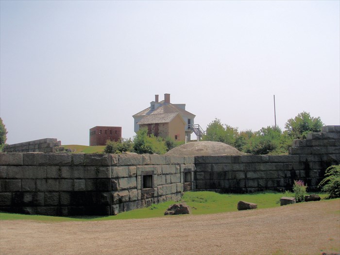
A caponier was constructed on the southern apex of the outer wall located at the river's edge. A bastion (mislabeled as a caponier on the state brochure) for flank howitzers was built on the northern apex of the outer wall, enclosing the well. A large granite powder magazine was built adjacent to the bastion. Another planned bastion at the northeastern apex of the outer wall was never built. A guardhouse and hospital were also built at this time, about 500 yards north of the blockhouse. They no longer exist. Several 250-lb (10-inch) Seacoast Parrott rifles were added to the Lower Battery to keep the fort functional.
Only one tier of the outer wall ever neared completion, and in 1868 all work was suspended. No new guns were ever mounted on the new work. Scores of cut granite blocks still lie in their positions on the ground to this day.
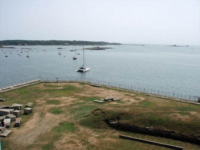
The old circular granite wall at the Lower Battery was modified into a broad earthwork in 1874, with three temporary wooden gun platforms. It still basically exists this way today. In 1890 nine 15-inch smooth-bore Rodmans, with seven iron carriages, were brought here and placed in storage, replacing the Parrott guns on the Lower Battery. These older guns were the only armament available to the fort during this time. Three of the Rodmans were emplaced at the Lower Battery in 1898 during the Spanish-American War. The six additional Rodmans, with four iron carriages, were unmounted in storage, as well as two remaining 250-lb Parrott guns with iron carriages, until 1905. All were scrapped or sold by 1910. Many of the buildings began to fall into disrepair during this period. The fort was not garrisoned at all during this time, except briefly in 1898 with a detachment from Fort Constitution in New Castle. A final small parcel of land was sold to the federal government in 1893.
During World War I, as a subpost of Fort Foster (which was built on Gerrish Island in 1899), the blockhouse was used as a lookout post, aiding Fort Constitution and Fort Foster for the defense of the harbor.
In 1918 the fort was deactivated. In 1924 the United States transferred most of the property (25.58 acres) to the State of Maine, except for the original 1.87 acres containing the old buildings, which was not transferred until 1961 due to legal issues with Massachusetts. The buildings by this time had fallen into ruin. The second Rifleman's house was razed in 1928 for safety reasons. The barracks still existed at this time, based on photographs of the period. The Town of Kittery managed the park for several years until 1937, before the State of Maine took responsibility.
From 1942-1945 the blockhouse was again used as a lookout post by local Civil Defense units for spotting overhead aircraft and ships in the harbor.
In 1969 Fort McClary was placed on the National Register of Historic Places. The blockhouse was refurbished in 1987."