|
 Havis Georgia Battery Marker - Chickamauga National Battlefield Posted by:  Lat34North Lat34North
N 34° 55.259 W 085° 15.701
16S E 658785 N 3865659
The Havis' Georgia Battery marker is located on Poe Road (one way) near driving tour stop 3, Chickamauga National Battlefield.
Waymark Code: WME0FV
Location: Georgia, United States
Date Posted: 03/17/2012
Views: 2
This marker is dedicated to Havis' Georgia Battery and is in recognition of their service during the Battle of Chickamauga, fought September 19–20, 1863. This is the only marker to Havis Georgia Battery on the battlefield. It marks their location at noon on Sept. 20, 1863.
Infantry
Text:
C.S.A.
Georgia
Havis' Battery
Capt. M. W. Havis.
Robertson’s
Reserve Artillery.
Army of Tennessee.
Noon, Sept. 20, 1863
From a nearby marker:
| Havis’ Georgia Battery |
| |
| 2 Napoleons, 1 James Rifle |
| Robertson’s Reserve |
| September 20, 1863. |
| |
| | Capt. M. W. Havis, Commanding | |
| | 1st Lieut. James R. Duncan | |
| | 1st Lieut. Hamblin R. Felder | |
| | 2d Lieut. C. H. Smith | |
| | 2d Lieut. James R. Rice | |
| |
| |
This battery was not engaged on the 19th. Soon after noon on the 20th
it came into position on this ground and opened fire on the enemy then falling
back on Snodgrass Hill. About 5:00 PM the battery took
position on the left of Major Williams’ Battalion, in front of and west of this ground,
and opened fire on the enemy's line east of the Kelly Field, taking it in
reverse, and continued to fire till his line at that point was abandoned and
the Confederate Infantry line intervened. Casualties: Men Killed 1, Men
Wounded 1, Horses Killed 1, Horses Wounded 1.
|
From the NRHP nomination form:
| |
Structure Number: |
MT-1258 |
| |
LCS ID: |
008861 |
Historical Significance:
| |
National Register Status:
|
Entered - Documented
|
| |
National Register Date:
|
07/25/1986
|
| |
National Historic Landmark?: |
No
|
| |
Significance Level:
|
Contributing
|
| |
Short Significance Description:
|
Monument contributes to nat'l significance of the park under NR Criterion A because it represents the national movement among veterans to commemorate Civil War battlefields. This was the first U.S. national military park.
|
Short Physical Description
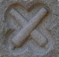
A rock-faced, peaked-top granite slab, 4'6" wide x 6' high x 1'8" thick, that carries an inscription, with crossed cannon barrels carved in relief above it. Marks unit's position on September 20, 1863, at 12:00 noon.
Material(s)
|
|
Structural Component(s)
|
Material(s)
|
1.
|
Superstructure
|
Granite
|
|
Construction Period:
|
Historic
|
Chronology:
|
|
Physical Event
|
Begin Year
|
Begin Year AD/BC
|
End Year
|
End Year AD/BC
|
Designer
|
Designer Occupation
|
1.
|
Built
|
1898
|
AD
|
1899
|
AD
|
|
|
|
My Sources
1. NRHP
2. Wikipedia - Battle of Chickamauga
3. The Civil War Home - The Chickamauga Campaign - Confederate Order of Battle
Note
Trailhead Graphics, Inc. has produced a map of the Chickamauga Battlefield showing the locations of all of the monuments and the markers on the battlefield. Each location on the map has a number associated with it that cross-references to an index on the back of the map that has the name of the marker (called the Chick-Chatt NMP monument numbering system). This number corresponds to the structure Number listed on the NPS List of Classified Structures that is normally prefixed with the letters MT for the Chickamauga Battlefield.
Website pertaining to the memorial: [Web Link]

List if there are any visiting hours:
Sunrsie to sunset
Entrance fees (if it applies): 0.00
Type of memorial: Monument
|
Visit Instructions:
*(1.)* Please submit a photo(s) taken by you of your visit to the location (non-copyrighted photos only). GPS photos are also accepted with the location in the background, and old vacation photos are accepted. If you are not able to provide a photo, then please describe your visit or give a story about the visit.
*(2.)* If you have additional information about the memorial which is not listed in the waymark description, please notify the waymark owner to have it added, and please post the information in your visit log.
|