
D River Beach Wayside - Lincoln City, OR
Posted by:  silverquill
N 44° 58.035 W 124° 01.020
10T E 419799 N 4979815
This is a day use area on the south bank of the D River with access to the beach.
Waymark Code: WMCX0T
Location: Oregon, United States
Date Posted: 10/21/2011
Views: 16
D RIVER
Lincoln City, Oregon
This has always been a landmark and curiosity on the drive along the scenic Oregon Coast Highway, U.S. 101. The D River is the outlet for
Devil's Lake, flowing under the highway into the Pacific Ocean. Depending on where the entry point and exit points are determined, the length may be 120 feet (the current claimed measurement) or as much as 440 ft., its designated length when it was listed in the
Guinness Book of World Records. The listing for "shortest river" no longer appears in the book.
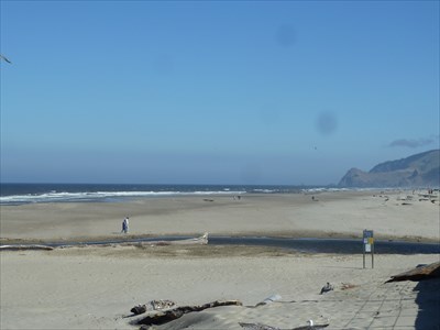
Regardless of its status, this is a beautiful location with this state day use park on the south side of the River, with access to the beaches which stretch for many miles. The beach is flat, windy and yields gorgeous sunsets. Park is open 6:00 am to 10:00 pm.
NOTE that this area is in a tsunami warning area and there is an informational sign explaining the geology of the area and how tsunamis are created along with instructions on what to do in case of a tsunami.
Unfortunately, a restaurant was allowed to be built on the north edge of the river on pilings out over the beach, greatly detracting from its scenic beauty, and completely blocking the view to the north until one actually gets past it onto the beach.
This park is also host to two of the largest kite festivals in the country, one in the fall and one in the spring.
Lincoln City is a town of about 8,000 which was incorporated in 1965 in a merger of several small coastal communities. It has become an increasingly popular tourist destination with facilities near this river and beach.
The coordinates for this waymark are recorded at the northwest corner of the park nearest the river's destination with the Pacific Ocean.