
Burrewarra Trig, Burrewarra Point, Guerilla Bay, NSW
Posted by:  SamWalkers
S 35° 50.042 E 150° 14.013
56H E 250114 N 6030926
Burrewarra Point :: 55m
Located on the headland south of Guerilla Bay.
The most easterly point on this part of the coast, adjacent to the light house.
Waymark Code: WM9QK8
Location: New South Wales, Australia
Date Posted: 09/19/2010
Views: 16
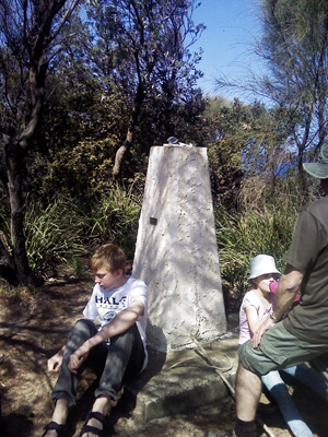
Burrewarra Trig
is a concrete cairn type trig situated in
Burrewarra Point Reserve.
It has become overgrown with the coastal heath. There is a light house (or probably more correctly, a light tower) that you can see above the scrub on your approach was first commissioned 1974.
There is an easy walking access from Burri Point Road, Guerilla Bay or do as we did and take the Costal Walking Track from Barlings Beach travelling over many headlands and clif tops. Start at S35º 49.811 E150º 12.336 and look for the path that goes up, not along the beach.
Along the way we found the native Orchids in bloom and a lot of fantastic fungus forms.
The whale migration was on and from Long Nose Point we could se a pod of at least ten whales breaching. Though too far off shore for photography they were an exciting sight.
If you are caching along the way there is http://coord.info/GC1W1VJ "Barlings View".