
John Messinger, 1771-1846
Posted by:  BruceS
N 38° 32.958 W 089° 57.964
16S E 241515 N 4270935
Historical marker north of Belleville, Il
Waymark Code: WM9EM
Location: Illinois, United States
Date Posted: 03/25/2006
Views: 33
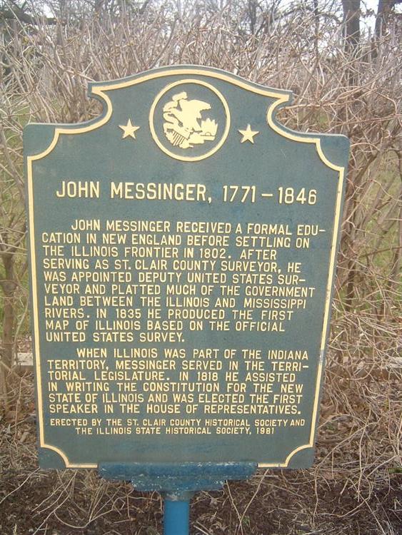
"John Messinger received a formal education in New England before settling on
the Illinois frontier in 1802. After serving as St. Clair county surveyor, he
was appointed Deputy United States Surveyor and platted much of the government
land between the Illinois and Mississippi Rivers. In 1835 he produced the first
map of Illinois based on the official United States Survey. When Illinois was
part of the Indiana territory, Messinger served in the territorial legislature.
In 1818 he assisted in writing the constitution for the new State of Illinois
and was elected the First Speaker in the House of Representatives."
~ from marker
The Messinger Cemetery is located behind the marker.
Visit Instructions:To log your visit please include the following:
- A picture of the marker. Including yourself in the picture would be nice but not required.
- Tell about your experience, thoughts, knowledge of the site or anything else you feel you want to share about your visit.
Reminder: In Waymarking, it is not bad etiquette to log your own Waymark. Please feel free log a visit for any marker you submit.