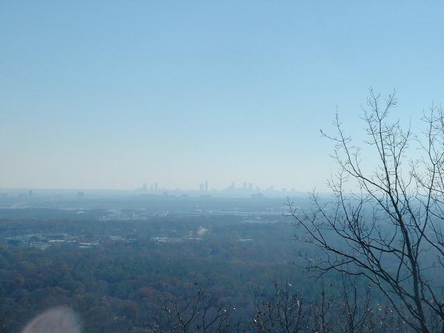
View from N33 58.670 W84 34.647
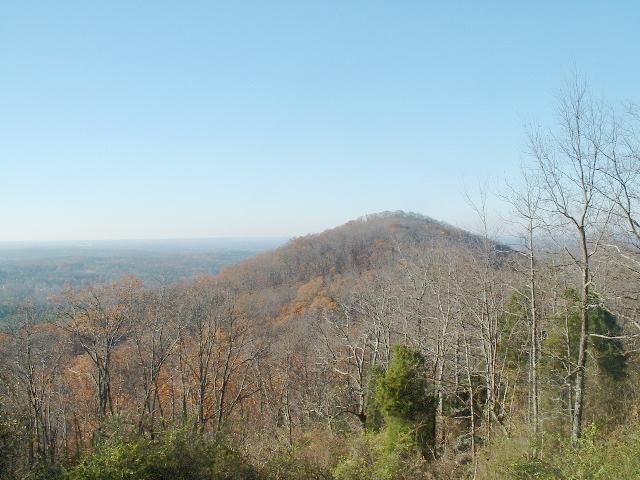
View from N33 58.519 W84 34.896 Little Kennesaw Mt.
SUMMIT N33°58.573 W084°34.763

Google Earth

The name Kennesaw is derived from the Cherokee Indian "Gah-nee-sah" meaning cemetery or burial ground. Kennesaw Mountain Battlefield is a 2,888 acre National Battlefield that preserves a Civil War battleground of the Atlanta Campaign. The battle was fought here from June 18, 1864 until July 2, 1864. Shermans army consisted of 100,000 men, 254 guns and 35,000 horses. Johnstons army had 63,000 men and 187 guns. Over 67,000 soldiers were killed, wounded and captured during the Campaign. There are 3 battlefield areas at the park: In front of the Visitor Center, off Burnt Hickory Road and the main site is located at Cheatham Hill [then commonly known as the Dead Angle]. The visitor center provides introductory information about the park and the battle. While walking some of the 17.3 miles of interpretive walking trails you will see historic earthworks, cannon emplacements and various interpretive signs. There are 3 monuments representing states who fought here. Kennesaw Mountain is 1808 feet above sea level. It is approximately a 700 foot incline from the Visitor Center to the mountain's summit. The hike up is approximately 1.4 miles on the road and 1.2 mile up the trail. PLEASE help us preserve this park by TAKING ONLY PICTURES AND LEAVING ONLY FOOTPRINTS.
The Mission of Kennesaw Mountain National Battlefield: Kennesaw Mountain National Battlefield Park was authorized for protection by the War Department in 1917 and was transferred to the Department of the Interior as a unit of the National Park System in 1933. The 2,888 acre park includes the site of some of the heaviest fighting of the Atlanta Campaign of the Civil War. The park was set aside as an important cultural property dedicated to public inspiration and interpretation of the significant historic events that occurred here.
TRAIL INFORMATION
The entire length of Kennesaw Mountain National Battlefield Park is covered by well-maintained and highly used trails. The most popular trail, the paved road to the top of Kennesaw Mountain, is closed to motor vehicles on the weekend. This trail winds over a mile from the base of the mountain near the visitor's center to a parking lot near the top of the mountain. Along the way are entrenchments, an old road, and two spectacular views.
Although the park lists 17.3 miles of trails, there are actually more, frequently paths created by hikers. Since much of the area is covered by fragile entrenchments, our recommendation is to stay on the marked paths. If no marker exists, it probably isn't a path. All legitimate paths are well-marked with easily-spotted signs in most areas.
The first leg of the loop is Mountaintop Trail. It parallels Mountain Road for much of the journey, leaving the road shortly after a scenic overlook. At the top it passes through the parking lot and continues to the actual top of Kennesaw Mountain. The Burnt Hickory Loop Trail, which includes Mountaintop Trail, is a steep, strenuous trail. From the top of Kennesaw, the trail continues almost due south to Burnt Hickory Road. It also climbs Little Kennesaw and Pigeon Hill.
Just before Burnt Hickory Road a trail to the right takes you around to the east side of Pigeon Hill. This trail then intersects with the Cheatham Hill Connector. To return to the Visitor's Center, turn right.
The Cheatham Hill Connector has a number of different trails on the north side of John Ward Creek, but the path essentially runs from the parking area at Burnt Hickory Road to the Cheatham Hill Loop. The path features a wide variety of plant and animal life as it descends to and crosses the creek then rises to open fields at or near the top of a low ridge that runs along the southern end of the trail. The southern end of the connector is not a loop, and the same path must be walked both ways. The Dallas Highway is a heavily travelled road. Please use great caution (and patience) in crossing. South of Dallas Highway the connector passes a number of interesting sights (for more information please see the Tour page).
Cheatham Hill Loop was the center of fighting on June 27, 1864. Forced into a stalemate (or so he thought), William Tecumseh Sherman ordered a frontal assault on the Confederate line in this area. It was one of the worst disasters of the Atlanta Campaign. Just over a mile, including side paths, the trail is heavily used and parking is sometimes a problem on weekends.
South of Cheatham Hill is an easy loop, just under 6 miles long that takes you through rolling hills to Kolb's Farm. Built in 1836 by Peter Kolb, the farmhouse has been restored to its original style. The house itself is a residence and cannot be visited. On the western side of the loop songbirds now fill the air where Rebels under the command of John Bell Hood attacked Hooker's XX Corps on June 22, 1864.
All these trails can be combined into a 17.3 mile loop, although we do not recommend attempting this loop in a single day, since camping is not allowed in the park (strictly enforced).
Spring is an exceptional time at Kennesaw Mountain. For more on the wildflowers that make it so, visit Dr. Mary Coeli Meyer's Spring on Kennesaw Mountain