
BLACKSHEAR TRAIL - GHM 40-1 Crisp CO. GA
Posted by:  GA Cacher
N 31° 56.743 W 083° 49.128
17R E 233544 N 3537888
Blackshear State Historical Marker
Located on Ga. 300 approx. 1 mile southwest of US 280 junction, west of Cordele, Ga.
Waymark Code: WM3RQT
Location: Georgia, United States
Date Posted: 05/12/2008
Views: 22
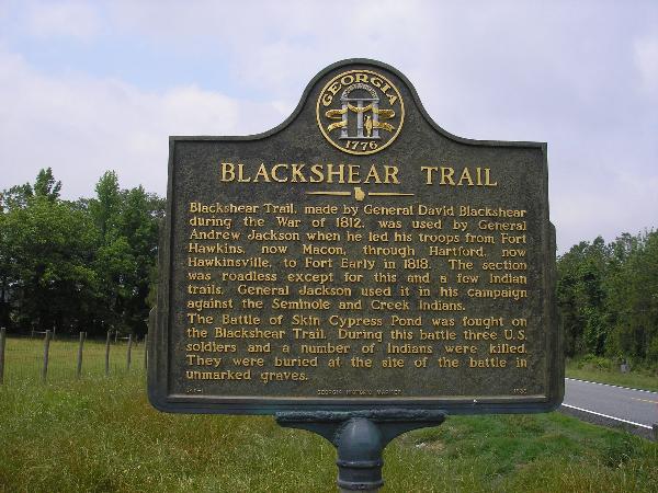
BLACKSHEAR TRAIL
Blackshear Trail, made by General David Blackshear during the War of
1812, was used by General Andrew Jackson when he led his
troops from Fort Hawkins, now Macon, through Hartford,
now Hawkinsville, to Fort Early in 1818. The section was roadless
except for this and a few Indian trails. General Jackson
used it in his campaign against the Seminole and Creek Indians.
The Battle of Skin Cypress Pond was fought on the Blackshear Trail.
During the battle three U.S. soldiers and a number of Indians
were killed. They were buried at the site of the battle in
unmarked graves.
040-1 GEORGIA HISTORICAL COMMISSION 1989