
Glacial Lake Missoula Water Level at Cabinet Gorge Dam, Idaho
Posted by:  Rose Red
N 48° 05.252 W 116° 03.544
11U E 570070 N 5326457
Massive dams of glacial ice once blocked water from leaving western Montana--until their catastrophic failures.
Waymark Code: WM23G9
Location: Idaho, United States
Date Posted: 08/29/2007
Views: 139
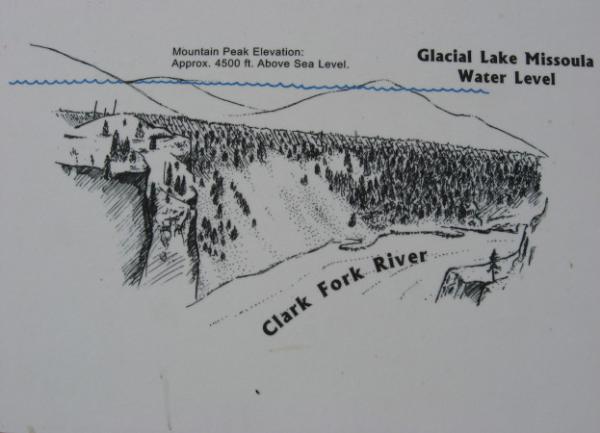
Glacial ice from the Cordilleran Ice Sheet moved south near the end of the last ice age, stopping the flow of water down the Clark Fork River Valley and creating massive Glacial Lake Missoula. The ice dam was 2,000 feet high and 30 miles wide. A glacial lake was created that covered much of present-day western Montana under approximately 2,000 feet of water in a 200-mile-long lake roughly the size of Lake Erie and Lake Ontario combined. When the ice dam failed, water roared at speeds up to 65 mph across northern Idaho, eastern Washington, and Oregon to the Pacific Ocean in the largest and most powerful freshwater flood known to have occurred on earth. There was as many as 40 to 100 floods.