
US (Alaska)-Canada (Yukon) Alaska Highway
N 62° 36.894 W 141° 00.087
7V E 499925 N 6942683
This is the border crossing on the famous ALCAN highway.
Waymark Code: WM1Y5
Location: Alaska, United States
Date Posted: 09/25/2005
Views: 189
Completed in 1942, the ALCAN highway (also known as the Alaska highway) was created to send supplies and troops to Alaska after the bombing of Pearl Harbor. The road stretches 2,288 km/1422 miles from Dawson Creek, British Columbia to Delta Junction, Alaska.
From Dawson Creek, the highway extends almost 968 km/595 miles to Lower Post where it enters the Yukon. The highway winds through the Yukon for about 885 km/550 miles and crosses into Alaska at mile 1221/km 1964
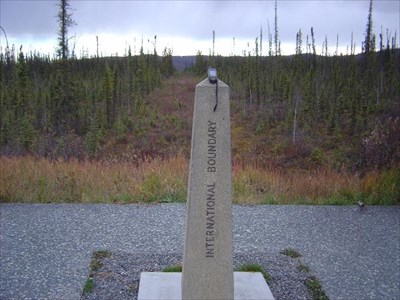
This Waymark is located at the small rest area just south of US customs (mile 1221.5).
Continuing on to Delta Junction at mile 1422/km 2288, the Alaska Highway joins the Richardson Highway for the remaining 98 miles/158 km to Fairbanks.
For more information on the highway check out the wiki page:
WIKIPEDIA LISTING
-UA
Visit Instructions:-Your own picture of the signs or area. Discussing why it is you are crossing this border gets you bonus points.
-No one likes to read ‘TFTW’ and other unimaginitive visit logs.
-Armchair finds can be deleted by the owner or management group.