Moyie Springs is a small rural community in Boundary County the most northern county in Idaho with approximately 1,165 residents. It was incorporated in the 1950s as the county’s second city, which it owed in part to the mill and the logging industry. The mill, which perches on a cliff above the Moyie River, is to this day the largest business in town.
Moyie Springs is just minutes from the Montana border and about an hour from the Canadian border and is near the confluence of the Moyie and Kootenai rivers.
One of the most outstanding places to visit is Moyie Dam. Moyie Dam is located on the Moyie River about one and one-half miles upstream of its confluence with the Kootenai River. It is a 92-foot-high concrete gravity dam that impounds a small reservoir, approximately one mile long. The length of the top of the Dam along the walkway at elevation 2040 is 376 feet.
 Moyie Springs, Idaho
Moyie Springs is a city in Boundary County, Idaho, United States. The population was 718 at the 2010 census.
Geography
Moyie Springs is located at 48°43'29?N 116°11'37?W (48.724599, -116.193585).
According to the United States Census Bureau, the city has a total area of 1.52 square miles (3.94 km2), all of it land.
Moyie Springs is located near the confluence of the Moyie and Kootenai rivers.
Demographics
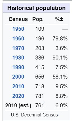
At the 2020 census,[2] there were 718 people, 270 households and 190 families residing in the city. The population density was 472.4 per square mile (182.4/km2). There were 297 housing units at an average density of 195.4 per square mile (75.4/km2). The racial make-up of the city was 93.6% White, 0.8% African American, 0.7% Native American, 0.1% Asian, 1.7% from other races, and 3.1% from two or more races. Hispanic or Latino of any race were 7.7% of the population.
There were 270 households, of which 41.5% had children under the age of 18 living with them, 51.1% were married couples living together, 11.1% had a female householder with no husband present, 8.1% had a male householder with no wife present, and 29.6% were non-families. 24.1% of all households were made up of individuals, and 8.9% had someone living alone who was 65 years of age or older. The average household size was 2.66 and the average family size was 3.12.
The median age was 32.3 years. 31.8% of residents were under the age of 18; 6.5% were between the ages of 18 and 24; 26.8% were from 25 to 44; 24.1% were from 45 to 64; and 10.6% were 65 years of age or older. The gender make-up was 48.6% male and 51.4% female.
2000 census
At the 2000 census,[7] there were 656 people, 240 households and 177 families residing in the city. The population density was 432.5 per square mile (167.0/km2). There were 254 housing units at an average density of 167.5 per square mile (64.7/km2). The racial make-up was 98.02% White, 0.76% Native American, 0.15% Asian, 0.61% from other races, and 0.46% from two or more races. Hispanic or Latino of any race were 2.44% of the population.
There were 240 households, of which 38.3% had children under the age of 18 living with them, 60.8% were married couples living together, 9.6% had a female householder with no husband present, and 26.3% were non-families. 18.3% of all households were made up of individuals, and 5.0% had someone living alone who was 65 years of age or older. The average household size was 2.73 and the average family size was 3.14.
32.8% of the population were under the age of 18, 6.9% from 18 to 24, 27.9% from 25 to 44, 20.7% from 45 to 64, and 11.7% who were 65 years of age or older. The median age was 32 years. For every 100 females, there were 88.0 males. For every 100 females age 18 and over, there were 90.9 males.
The median household income was $35,781 and the median family income was $36,042. Males had a median income of $32,788 and females $30,500. The per capita income was $15,516. About 13.6% of families and 17.6% of the population were below the poverty line, including 21.9% of those under age 18 and 6.1% of those age 65 or over.
Politics
Presidential elections results
Statewide elections results
Education
There is one school district in Boundary County: Boundary County School District 101.
Boundary County is in the catchment area, but not the taxation zone, for North Idaho College.
From Wikipedia, the free encyclopedia