Until 1887, these dry hills lay undisturbed by man but, that year, a prospector known as
One-Armed Reed explored here for gold and, in 1888, two others, Gwatkin and Shehan, were Crown-granted the Sidewinder Claim. Many other interests were staked and, by 1893, Fairview the place boasted of being
The biggest city north of San Francisco.
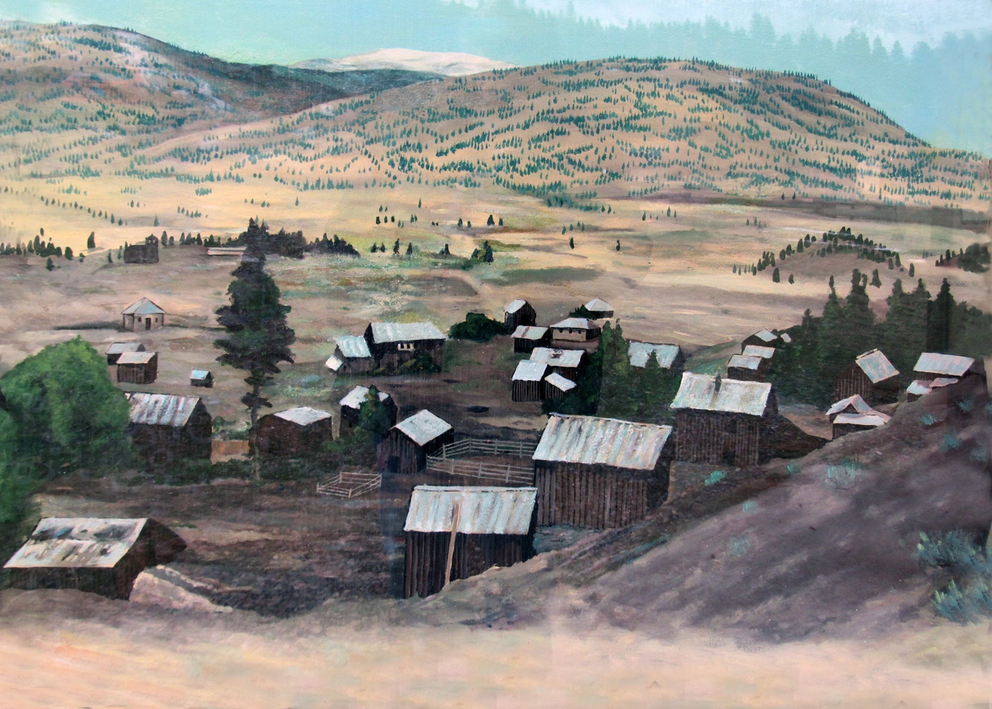
Along
The Gulch, close to the mines, buildings were erected and saloons, like
Moffat's, the
Golden Gate, the
Bucket of Blood and
The Miner's Rest served the needs of the roistering population. To the southeast of
The Gulch the townsite of Fairview was laid out. It was here, in 1897, that Fairview's Grand Hotel, nicknamed
The Big Tee-Pee, was built. Five years later it burned down, with the loss of two lives. Many years later the ground on which the hotel had stood was screened, yielding dozens of gold and silver artefacts and coins.
By 1906, when Fairview’s gold began to play out, most miners departed for other prospects and, two years later, Fairview had become a ghost town.
By 1919, “
the most exciting town in the West" had vanished, although mining activity revived to some extent during the Great Depression and, between 1934 and 1939, 16,992 ounces of gold and 162,660 ounces of silver flowed from these hills.
Essentially nothing remains of Fairview except several historical markers. The site of the Presbyterian Church has been marked, but is otherwise indistinguishable from the surroundings. Constructed at Fairview in 1899, it was moved to Okanagan Falls in 1929 and is affectionately known as
The Blasted Church for the method in which it was disassembled for transport (Hint - dynamite was involved). The wooden
Fairview Jail, the last remnant of Fairview, was moved to the Oliver Museum in 1981.

Fairview Mining District
Description of Historic Place:
The Fairview Mining District consists of sites and the
remnants of built structures scattered throughout the
western side of the Okanagan Valley in an area
approximately bound by: the western boundary of
RDOS Area C, Fairview-White Lake Road, Orofino
Creek and Tin Horn Creek . and includes the former
Town site of Fairview.
Heritage Value:
Colonization:
The Fairview District is considered by many early settlers and their descendants as the beginning of permanent European settlement in the area, as it is to this location they trace their family’s original arrival. It forms a core part of the identity of the community’s genesis.
Economic:
The Fairview Mining District is a reminder of the investment from British investors in mining and development of this area from 1887 to about 1900. The presence of the mine shafts and other built structures reminds the community that this area still has as yet unrealized mineral resource potential.
Landmark:
The name of Fairview has persisted as an iconic location to residents of Area C and appears associated with the former town site, the golf course, and existing buildings. It is from this area that there are many picturesque views of the Valley, including an uninterrupted view towards Osoyoos Lake.
Social:
Within the Fairview Mining District, there is a cemetery which is maintained by the Okanagan Historical Society. The cemetery includes a section memorializing the five Tholl children, who all passed away due to diphtheria, and stands as a reminder of the hardships of life on the frontier of Canada.
Character-Defining Elements:
Key elements that define the heritage character of the CN Railway Bridge include its:
- The presence of a wide range of engineered structures, including mine shafts, adits, mine tailings, roads, trails, ore cart tracks and ore crusher footings, including the Tin Horn Stamp Mill, the best preserved mining structure in situ
- The presence of building lots which are remnants of past mining claims
- The presence of Fairview Pioneer Cemetery
- The presence of an apricot tree and rye field near the former site of the Boone property
- The presence of lilac bushes marking the location of the Carmichael property
- The presence of cabin structures which are the remnants of both homes and businesses
- The use of the name ‘Fairview’ to describe the area
- Uninterrupted views of almost all significant sites and landmarks in the South Okanagan
From RDOS Heritage Register
![]()