This heritage site follows the Okanagan River from Vaseux Lake, south of the town of Okanagan Falls, to the site of the last engineered work, a dam, just south of Road 22, about 6 kilometres north of Osoyoos. The corridor extends a total of about 32 kilometres along the southern end of the Okanagan Valley.
While most sections of the river have been channelized from its mouth at the south end Of Okanagan Lake, the 30 kilometre section from there to Vaseux Lake is not included in this site.
Along the river from Vaseux Lake to just south of Road 22 near Osoyoos are 19 dams, a handful of which also serve as road bridges. Between Oliver and Osoyoos Lake, 17 of the 19 are smaller man-made dams known as Vertical Drop Structures. Each Vertical Drop Structure is designed to raise the water level of the river one metre, thereby increasing the storage capacity of the river. Designed to regulate the flow of water as it gradients downhill, these dams had to be built when the river was channelized, to prevent the water from flowing too quickly and posing a downstream threat to habitat erosion, fish migration and human safety.
An ambitious irrigation scheme, the
South Okanagan Lands
Project, begun in 1918 by then Premier John Oliver would soon turn the southern Okanagan from a desert wasteland to a highly productive farming, market gardening and wine producing area. The area became so productive so quickly that, in 1920, the CPR deemed it necessary to begin construction of a spur line, the Osoyoos Subdivision, south from Penticton, eventually to reach Osoyoos at the U.S. border.
The irrigation scheme consisted of 2 major parts:
1 - Channeling the Okanagan River which flows south from Okanagan Lake.
2 - Creating a canal, known locally as
The Ditch, coming off the river south of Vaseux Lake to irrigate areas downstream which were higher the the river.
The Ditch is covered in a separate heritage registration.
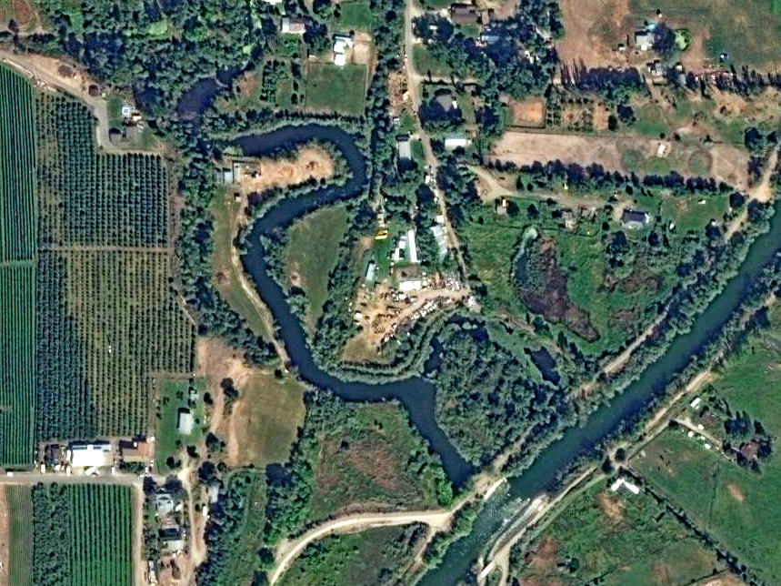
The Oxbows, sections of the original river channel, are included in the site. Since viewing the Oxbows from ground level seldom imparts a true impression of what they are I have included the satellite image below. It is representative of Oxbows in several locations along the river channel. The view is centered at approximately 49.206305, -119.550332, just north of the Town of Oliver. The Oxbow snakes downward near the centre of the image, while the new river channel flows through near the bottom right corner.
Okanagan River Corridor
Description of Historic Place:
This site consists of the river course and the riparian corridor through which the river passes. This site includes the southern section of Vaseux Lake which is in Regional District of Okanagan Similkameen Area C, and the entire length of the river through Area C to the southern border at Road 22. Also included are the oxbow lakes which mark the previous course of the river meanders, and the man made elements for control of water flow.
Heritage Value:
Economic:
The Okanagan River is the source of the water used in irrigation for the crops grown in the Oliver area. Without this significant water resource, the agricultural activity would not be possible. The river also serves as a reminder of the past fur trapping activity in the early part of the 1800s.
Environmental/Scientific:
The River has been identified as the third most endangered river in Canada because of the stress on this water resource. The river has been altered significantly through this section of the Okanagan Valley in order to control water flow, and the engineering and control of the river has been a major activity since Colonization. The resulting change in the ecosystem has prompted efforts to restore natural habitat for spawning salmon and other native plant and animal species. Throughout the history of water use, the riparian area has been important to sustaining wildlife present throughout the valley, most especially species of birds that make this corridor a recognized bird watching area.
Landmark:
The Okanagan River is a landmark used by travelers to mark passage through the area. Most locations in Area C are described in reference to where they are found relative to the River. The presence of the Okanagan River affirms ties this area has to other settlements further north, and south to the United States, ultimately debouching at the Columbia River. It is from the River that this area is recognized as the Okanagan Valley.
First Nations:
Before Colonization, the River was the source of salmon which was the main food resource for the Okanagan Nation. Camps and permanent settlements were located along the length of the river in this section of the Valley.
Recreation:
The river has been enjoyed for thousands of years as a place to swim, and as a place to hunt and fish. The riparian area along the river dykes has been developed as a section of an international hike and bike trail.
Character-Defining Elements:
Key elements that define the heritage character of the CN Railway Bridge include its:
- The presence of engineered works to use water from the river as an irrigation source
- The presence of engineered earthworks to control the flow of water in a relatively straight
- The presence of engineered earthworks to control the flow of water in a relatively straight course where required to conserve agricultural land
- The presence of engineered weirs to control rate of water flow
- The presence of oxbows lakes and meanders in the river
- The presence of activity to encourage salmon habitat
- The presence of a hike and bike trail
- The presence of a riparian area which includes unique plant and animal species
- The presence of archaeological sites
- The use of the site as a bird watching area
- The use of the river and corridor as a recreational area
From the RDOS Heritage Register