Beginning around 1865 John Carmichael Haynes began to acquire large amounts of ranch land in the Osoyoos and Oliver areas. It was one of the first cattle ranches in the Okanagan Valley, eventually reaching about 22,000 acres in size. Haynes also was judge as well as customs officer for the Osoyoos/US border crossing.
This was a very enjoyable trip down Black Sage Road, especially finding this old homestead.
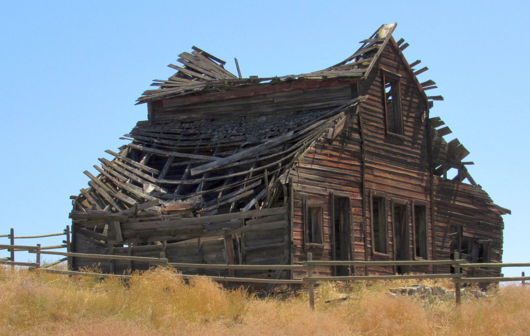
Across the road from the barn are two other buildings, the Ranch House and the Bunkhouse, the smaller being the Bunkhouse and the larger one the Ranch House. Unfortunately for all three remaining buildings, it doesn't look like they have much more time on this earth. If you continue down Road 22 you will encounter the Oxbow Preservation Area where the sign is located. Take time to enjoy this beautiful area.
 HAYNES RANCH BUILDINGS PRESERVATION PROJECT
These buildings, on the east side of the Okanagan River date from the pioneer cattle ranching era - ongoing, as some Haynes descendants still herd Herefords!
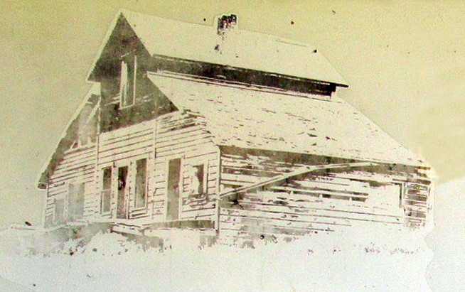
The house dates from 1860, built for Judge John Carmichael Haynes, who died in 1888. A later addition in 1875, and again in the last years of use, it was last inhabited in 1963.
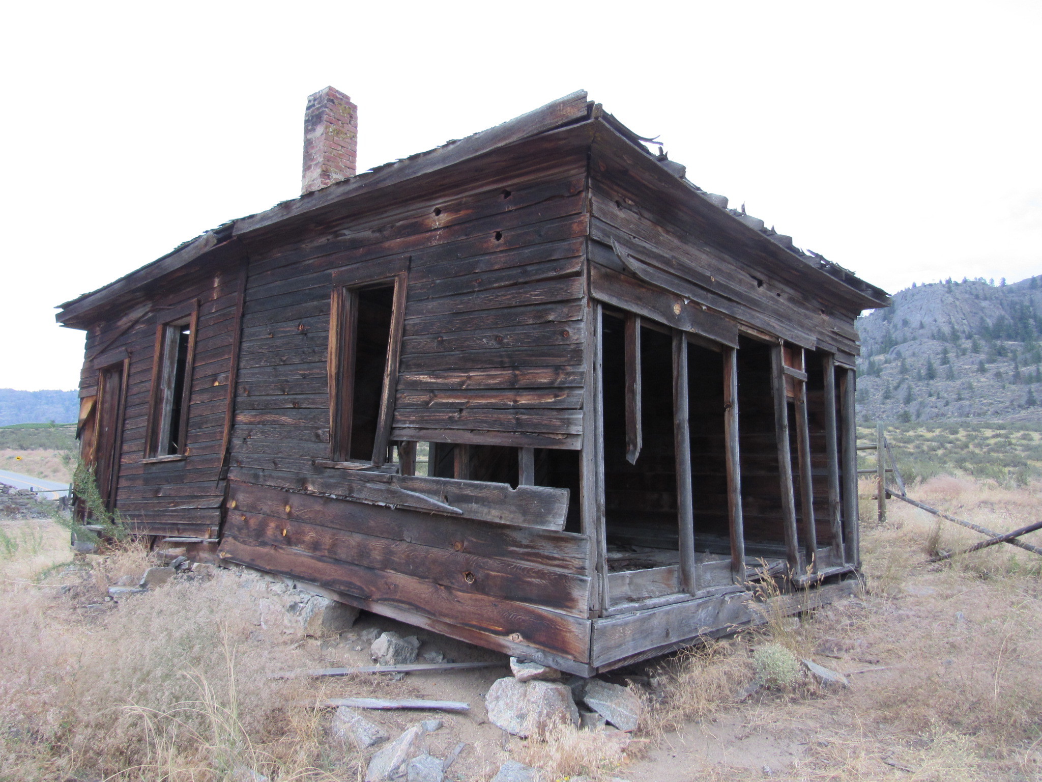
- The bunkhouse was built for son, Valentine (Val) Haynes, in 1911 for work crews, etc.
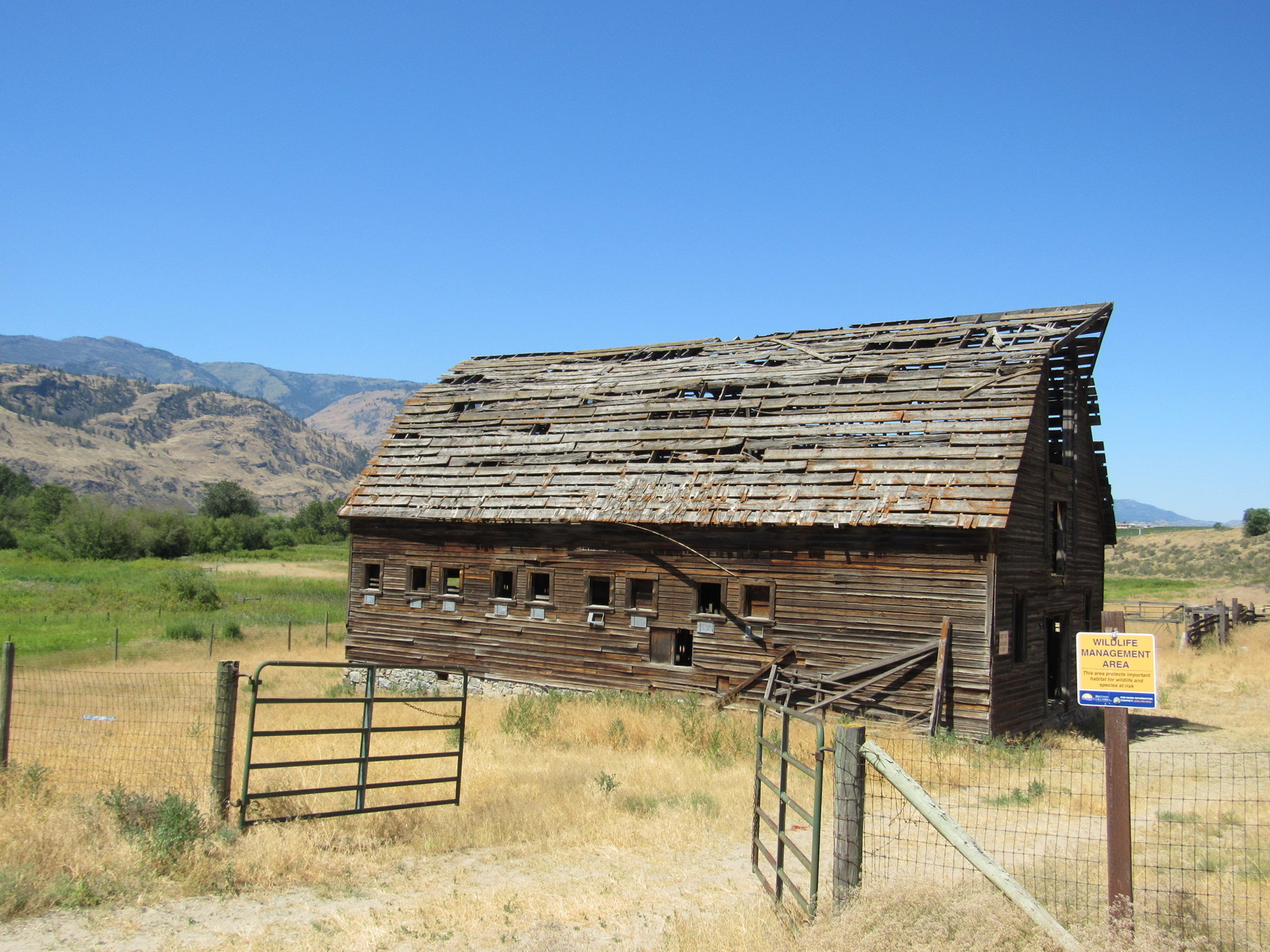
- The barn was built in approximately 1906, burned down in 1914, and was rebuilt again in 1916.
- Other sheds and the ice house have long since given in to the ravage of time.
- The root house - now fallen in, is home to some of our more exotic creatures.
- The attic is now home to long-eared bats.
Okanagan Historical Society (Oliver/Osoyoos Branch)
Sign Donated By Claudia Lajeunesse
Ministry of Water. Land and Air Protection
Transcribed from sign
Haynes Ranch
DESCRIPTION OF SITE:
The Haynes Ranch consists of a 1½ storey farmhouse, a “two piece” bunkhouse and a 2-storey gambrel-roofed barn, set in a typical working ranch landscape. The three decaying wooden buildings are located near an oxbow on the north and south sides of Road 22 at the junction of Black Sage Road in Area A of the Regional District of Okanagan-Similkameen.
HERITAGE VALUE OF SITE:
The Haynes Ranch is valued as an iconic landmark at the northern border of Area A. The rustic buildings offer a romantic snapshot of a lost era, one of cattle barons, vast estates and empire builders, from colonial times to the end of the First World War.
The Haynes Ranch also serves as a reminder of the earliest permanent colonial settlement in the South Okanagan region. Cattle ranching on a grand scale was carried out in the southern valleys of the Okanagan and Similkameen Rivers from the 1860s to 1920. Mr. Valentine (Val) Haynes, was a noted cattle rancher who contributed in various ways to the pioneer development of the area. He ran a pack horse supply train to Camp McKinney and worked as a foreman for the South Okanagan Lands Company cattle ranch.
The Haynes Ranch is also a physical reminder of the important role of First Nations in the vast cattle ranches of British Columbia. From the ranches of the Cariboo, to those of Haynes, Lowe, Richter and Ellis in the Okanagan Valley, the employment of the native population was an economic and social reality and many First Nations were employed as cattle ranchers, stock raisers and feed farmers. Valentine (Val) Haynes married Elizabeth Runnels who was of Syilx background.
Haynes Ranch is further valued as one of the few remaining ranches in the valley that has not been subdivided for orchards or other land uses. By 1918, fruit growing was replacing cattle ranching as the primary land use largely due to a marketing campaign waged by J.M Robinson and the Shatfords for small orchards and farms. Hundreds of 10 to 40 acre plots of land were created and sold for orchard lots to produce the fruit for which the Okanagan is now famous. By 1920, the breakup of the vast cattle ranches in the Okanagan was complete. Cattle ranching became a secondary industry, existing today only in the higher back valleys of White Lake, McLean Creek, Marron and Willowbrook.
The Haynes Ranch buildings and ranchlands are also valued for their vernacular architecture, construction materials, physical arrangement on the site and evidence of age. The Ranch House (circa 1880 – 1890) includes fieldstone foundations and a root cellar. The Bunkhouse (date unknown) was built in two sections. The barn (circa 1916) has a gambrel roof and fieldstone foundation. The buildings are arranged...[what is the arrangement? Is it around a barnyard, along the road...? Why is the arrangement important?]
CHARACTER DEFINING ELEMENTS:
Key elements that define the heritage character of Haynes Ranch include its:
Ranchland:
- Location near an oxbow lake at the junction of Road 22 and Black Sage Road
- Pastoral quality of the property, including its quiet environment
- Layout of vernacular ranch buildings on the property
The Ranch House
- Architectural qualities such as: wood frame construction, brick chimneys, fieldstone foundation and fieldstone root cellar
- Patina of age
- Orientation to the barns and the property
The Bunkhouse
- Fieldstone and concrete footing
- Patina of age
Barn
- Formal architectural qualities such as gambrel-shaped roof, shingle roof over 12” wide wood slats, wood frame windows and doors, and fieldstone and concrete footing
- Orientation to the ranch house and bunkhouse and to the property
- ? Patina of age
From the RDOS Heritage Register