CLINTON
THIS CAIRN MARKS THE JUNCTION OF TWO ROUTES
TO THE CARIBOO GOLD MINES. THE ORGINAL 1859
CARIBOO TRAIL FROM LILLOOET AND THE CARIBOO ROAD
THROUGH THE FRASER CANYON BUILT IN 1863
BY THE ROYAL ENGINEERS
ORGINALLY CALLED CUT OFF VALLEY, RENAMED
IN 1863 HONORING HENRY PELHAM CLINTON
5TH DUKE OF NEWCASTLE,
COLONIAL SECRETARY 1859 – 64
DERWARD SMITH
CLINTON’S LAND INSPECTOR
1955 – DESIGNED AND BUILT
THIS CAIRN WITH STONES HE
COLLECTED FROM BOTH
ROUTES
"CAIRN
This cairn was erected by the Clinton and District Chamber of Commerce in 1958. The cairn marks the junction of two routes: the original 1859 Cariboo Trail from Lillooet and the 1863 Cariboo Road through the Fraser Canyon that was built by the Royal Engineers. Derward Smith, as seen in the photograph, was Clinton’s Land Inspector, in 1953 designed and selected the stones in the cairn. All the stones were patiently and carefully collected from along both routes. The roads of the two routes were maintained with old fashioned tools - muscle power, shovels, wheelbarrows and a “scraper” pulled by a horse which served as a sort of grader. The cairn was declared a Municipal Heritage site by the Village of Clinton in 1989."
Source: Village of Clinton
Considering that this cairn was build in 1955, about 66 years ago, it is in excellent condition. The cairn is in the south end of Clinton in a business area, and across from the Clinton Emporium Antiques.
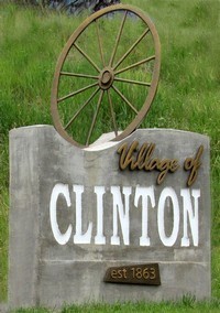 CLINTON
Originally known as "The 47 Mile", with the completion of the Douglas-Lilloet Road in 1861 and the Yale-Cariboo Road in 1863 "The Junction" became the townsite of Clinton. The townsite became an important settlement, providing supplies and rest for travelers to the Cariboo Gold Fields. The early 1900s gave rise to the lucrative forest industry. Clinton and area boast many good facilities and a landscaped park, while still retaining the flavour of a frontier town.
The village hosts the Clinton Ball, the longest running event in Canada since 1868.
transcribed from sign