At about 410 metres (1,350 feet) in total length, this stands as far and away the shortest Rail Trail we've ever encountered, and we've seen quite a few, stretching to
274 kilometres, not counting branch lines.
This little rail trail was originally a section of the Great Northern (GN) line from Marcus, WA to Oroville, WA, eventually extended Tulameen, BC. The line was built under two names in two countries, the Canadian sections (of which there were two) were built under the charter of the Vancouver, Victoria & Eastern (VV&E), the U.S. sections under a Great Northern charter. The point of the railroad was to reap the riches from copper, gold and silver mines in the Boundary Country of British Columbia and Washington.
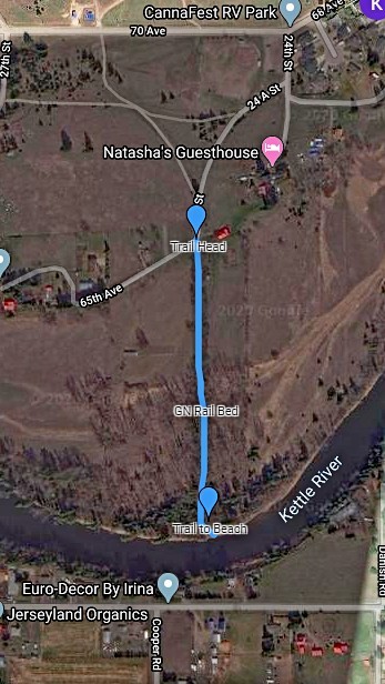
Building from Marcus, WA, to the southeast, the VV&E reached the Kettle River southwest of the fledgling settlement of Grand Prairie (whose name was soon changed to Grand Forks) in the spring of 1902. The bridge over the Kettle River at the south end of this rail trail was built that spring and the tracks were laid to a Wye located immediately north of the trailhead that summer. The line was officially opened for use on July 29, 1902. At the same time, large rail yards were built immediately northwest of the wye and a Great Northern station to the northeast, toward Grand Forks.
To the northwest about 13 kilometres was once a mining town named Phoenix, built to service mines at a large copper-gold-silver deposit. Just north of Grand Forks on the Granby River (then known as the North Fork of the Kettle River) a large copper smelter, the
Granby Smelter, was built to refine the output from those mines, as well as other mines on both sides of the U.S.-Canadian line. The Granby Smelter remained in operation from August 21, 1900 to mid 1919 and it was the intent of the GN to haul the ore from the mines to the smelter.
By 1919 the ore at Phoenix had played out, the Granby smelter closing not much later that same year. By August 1920 the GN had completed removal of tracks from Phoenix and the smelter back to Grand Forks, but through service between Marcus and Oroville continued for many years. The line was, by then, very much unprofitable and the final passenger train passed through in February of 1935, a westbound on the 27th which returned on the 28th. The GN station had been sold in 1930 and the tracks here were removed in 1936.
At the location of the wye, just to the north of the trail head, one can still see the grading work done by the GN for the tracks for some distance to the north and to the east. This short section of track leading south to the Kettle River must have been quite labour intensive, requiring up to 30 feet of fill, as the surrounding ground slopes down rather sharply at the trailhead and continues to slope down to the river.
GN RAIL TRAIL
Hidden behind Extra Foods are the old GN rail beds that brought passenger service into the city at the beginning of the 20th century. These rail beds have become roads but many of them still exist in the fields on the south side of 68th east of Spraggett Bridge. One of the most delightful trails is a short walk from the end of 25th Street and 65th Avenue. Drivers can park at Angus McDonald Park just off of 68th and stroll down 25th until you see the raised rail bed running straight to the Kettle River. It is less than 500 m to the river but it is a big wonder of engineering as the old rail bed is significantly raised above the surrounding fields.
Near the end of the trail the foot path veers off to the left to a beautiful little beach. If you stand at the end of the rail bed you can only wonder how the railroad once crossed the river. If you look closely and the waters are low you can see some of the timbers that supported this long forgotten trestle. If you examine this landscape on Google Maps you can see how this rail bed lined up with the Y on the south side of Carson Road.
From Grand Forks Trails