
Oliver, British Columbia - 1918 to Now
Posted by:  T0SHEA
N 49° 10.981 W 119° 33.090
11U E 314070 N 5450935
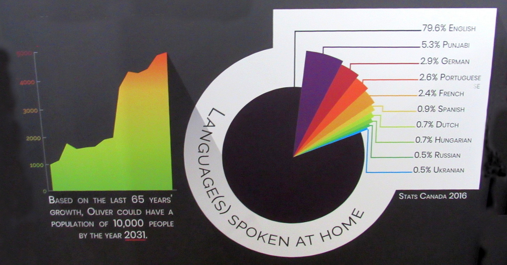
The Oliver timeline is inside the museum. Though there is not a set admission, donations are always welcome.
Waymark Code: WM12TP6
Location: British Columbia, Canada
Date Posted: 07/14/2020
Views: 0
The Oliver timeline is inside the museum. Though there is not a set admission, donations are always welcome. This is an interesting museum with many displays from Fairview which has almost entirely vanished. Along with this timeline is interesting history about John Oliver whom the town is named. The relocated Fairview jail is outside on the walking path of the Heritage Garden. There are many informational signs along the path explaining about local flora and fauna, local lakes and other points of interest.
1918 - Soldier Settlement established with four construction camps housing 100s of workers.
1920 - Soldier Settlement is given the name "Oliver", and is governed by the province of BC.
1921 - Oliver receives a post office and appears on the national census for the first time, builds its first two-room schoolhouse.
1922 - Electricity is brought to Oliver, BC Provincial Police station (including jail) is completed.
1923 - The Kettle Valley Railway reaches Oliver and a CPR station is built.
1926 - Oliver's population reaches 500 people.
1927 - The ditch project is finally completed. Oliver gets its first dentist, Dr. Lawrence Lundy.
1929 - 100 railcar loads of Oliver cantaloupes and 15000 crates of tomatoes are shipped to market, receives national attention.
1937 - Oliver Airport is built, population reaches 1,000 citizens, first vineyard is 5 years old and ready for harvest.
1941 - Jr./Sr. Consolidated School is built.
1942 - St Martin's hospital is built.
1945 - Oliver is officially incorporated as a village with a council of three members; R.W. Smith, George Stuart, and Doug Smithers.
1947 - South Okanagan Secondary School is built, channelization of the Okanagan River is begun.
1951 - Oliver's population reaches 1,000 people.
1955 - Channelization of the Okanagan river is completed.
1960 -Trump Ltd is established and begins developing new designs of hydraulic orcharding equipment.
1964 - SOLP Okanagan Lands Project) is replaced with the South Okanagan Lands & Irrigation District, and the first international Horse Show is h -eld..
1967 - Canada's Centennial, Oliver residents begin preparations to create a community museum.
1975 - Oliver's population reaches 2500 people.
1980s -Town of Oliver takes over management of irrigation ditch, St. Martin s Hospital is demolished and replaced with new hospital.
1990s - Oliver is incorporated as a Town, Dominion Radio 2000 Astrophysical Observatory unveils new, more powerful telescope as Canada's only radio observatory. World's Record is set with the Largest Cherry Pie (6.09m diameter, 17,106k)
2000s to now - Bhaysagar Sikh temple is established, Golden Mile wine region is officially recognized as a wine subregion, John Oliver Statue is erected in front of the Town office, population reaches 5,000 people.
Visit Instructions:At least one good photo you have personally obtained and a brief story of your visit. Any additions or corrections to the information about the Waymark (for instance, have the hours open to the public changed) will be greatly appreciated.