|
 Monument 154D - Danville, WA Posted by:  ScroogieII ScroogieII
N 49° 00.005 W 118° 30.180
11U E 390068 N 5428552
This is one of the myriad border monuments found at Canada - U.S. border crossings.
Waymark Code: WM12RQY
Location: Washington, United States
Date Posted: 07/08/2020
Views: 2
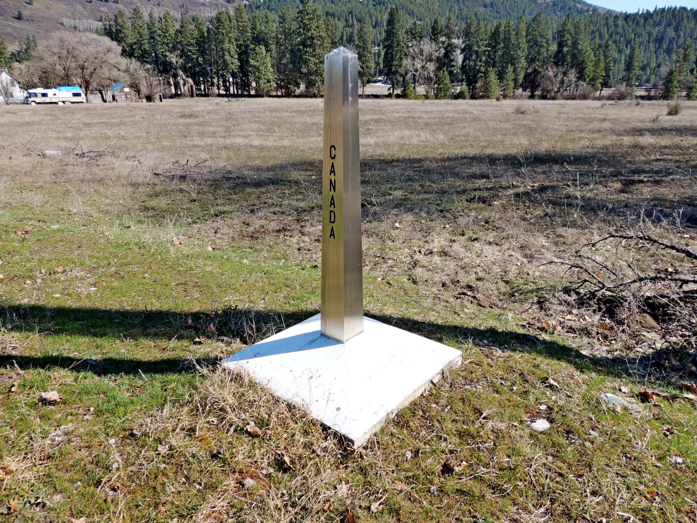
Originally there were two border monuments at this border crossing, Monuments 154A & 154B. They were a special type of monument (see description below), installed in pairs between 1928 and 1937 on each side of major border crossings. No descriptions are yet to be found for the new stainless steel monuments which are in place today. As well, none of the four, even the two originals, appear on the NOAA website.
With expansion of border crossing facilities several years ago the monuments in place at the time were moved and, apparently, two more added in 1987. Of the four that now mark the border at the Grand Forks, BC - Danville, WA crossing, MON 154D is the furthest east, 30 or 40 feet east of the east parking lot by the joint Canada-U.S. inspection station.
This type of monument is an ornamental concrete obelisk set in a plain concrete base. The surface of the obelisk or shaft is finished in light-colored granular quartz aggregate, washed free of cement so that the color and texture of the coarse granular aggregate shows clean. The shaft is 6 feet 6 inches in length and projects 5 to 5½ feet above the base. The inscriptions on the shaft of the monument are cast in black aggregate flush with the surface. They read vertically upward and are as follows: On the side facing the highway "INTERNATIONAL BOUNDARY", on the side away from the highway "TREATY OF 1925", on the north side "CANADA", on the south side "UNITED STATES."
From the International Boundary Commission Report - 1937, Pages 120-23
The International Boundary Line between the United States of America and the Dominion of Canada was adopted under article II of
the Convention of London of 1818, under article II of the Webster-Ashburton Treaty of 1842, and under article I of the treaty of 1846, and was modified by articles I and II of the treaty of 1925. The boundary begins at the eastern shore of Georgia Strait and follows the original astronomic determination of the parallel of 49° of north latitude to a point in Lake of the Woods. The International Boundary from the Gulf of Georgia (Georgia Strait) to the Northwesternmost Point of Lake of the Woods is marked by 959 monuments set on the boundary line. The part of the line which follows the astronomic determination of the forty-ninth parallel is commonly called the 49th parallel land boundary. It is 1270.2 miles in length.
The boundary was originally surveyed and marked between 1857 and 1861. In lesser populated areas it was sparsely monumented, so by 1898 questions as to the adequacy of the then present markings of this boundary began to arise. A complete remapping and monumenting of the boundary lying west of the Rocky Mountains took place from 1903 to 1907. From the Pacific Ocean to the summit of the Rocky Mountains there are 272 monuments.
East of the summit of the Rocky Mountains remapping and monumenting took place between 1908 and 1914. The monuments from the summit to Lake of the Woods total 641. Finally, the treaty of 1908 was adopted, providing for the more complete definition and demarcation of the International Boundary between the United States and Canada from the Atlantic Ocean to the Pacific Ocean.
West of the summit of the Rocky Mountains the boundary line is marked by aluminum-bronze monuments, set in concrete bases, the distance between monuments not exceeding 3 miles, save in very exceptional cases where 4 miles should not be exceeded. The same protocol applies east of the summit of the Rocky Mountains to the North Fork of the Milk River. From there east to Lake of the Woods one-piece hollow cast-iron monuments, filled with concrete, identical in form with those set in 1872-1875, mark the boundary at distances apart not exceeding 2 miles except in a few exceptional cases, where 2¼ miles should not be exceeded.
Paraphrased from the International Boundary Commission Report - 1937

Type of survey mark: Stainless steel obelisk

What indicators are near the mark to help people identify where it is located?:
30 to 40 feet east of parking lot, east of joint border station building.
What property is this mark defining?:
Canada - U.S. boundary
|
Visit Instructions:
Please submit a photo(s) taken by you of your visit to the location (non-copyrighted photos only). GPS photos are also accepted with the location in the background, and old vacation photos are accepted. If you are not able to provide a photo, then please describe your visit or give a story about the visit. If you have additional information about the survey mark which is not listed in the waymark description, please notify the waymark owner to have it added, and please post the information in your visit log.
Recent Visits/Logs:
| There are no logs for this waymark yet. |
|
|
|
|