 view gallery view gallery SW11.7 km SW11.7 km
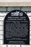
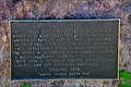
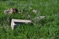
|   Wilson Homestead- The Pines 1901-1932 Wilson Homestead- The Pines 1901-1932
in Saskatchewan Historical Markers This is located West side of HWY 9, South of Crystal Lake. posted by:  Altima Voyageur Altima Voyageur location: Saskatchewan, Canada date approved: 01/27/2016 last visited: never |
 view gallery view gallery E11.9 km E11.9 km
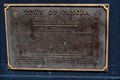
| Town of Norquay in Saskatchewan Historical Markers Located in park across from Robinson's Family Foods grocery store. posted by: Altima Voyageur location: Saskatchewan, Canada date approved: 01/27/2016 last visited: never |
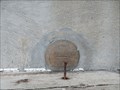
 view gallery view gallerySW15.1 km | Fort Alexandria (Damaged Cairn) in Saskatchewan Historical Markers This historical cairn was located south side of Assiniboine River and west side of Hwy 9. Fort Hibernia was located on north side of this river not far from coordinates. posted by: Altima Voyageur location: Saskatchewan, Canada date approved: 02/22/2016 last visited: never |
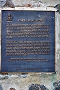
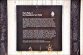
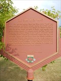
 view gallery view galleryE20.9 km |  CNHE Seat of the Territorial Government - Le Siège de L'Administration des Territoires (Fort Livingstone) CNHE Seat of the Territorial Government - Le Siège de L'Administration des Territoires (Fort Livingstone)
in Canadian National Historic Sites North of town of Pelly Saskatchewan. posted by: Altima Voyageur location: Saskatchewan, Canada date approved: 09/23/2017 last visited: never |
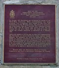 view gallery view galleryE20.9 km | Seat of the Territorial Government - Le Siège de L'Administration des Territoires 1876-1878 in Saskatchewan Historical Markers This is located North of town of Pelly, in the Fort Livingstone National Historic Site. posted by: Altima Voyageur location: Saskatchewan, Canada date approved: 01/27/2016 last visited: never |
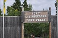
 view gallery view galleryE20.9 km | Fort Livingstone in Saskatchewan Historical Markers This is located North of the town of Pelly Saskatchewan. posted by: Altima Voyageur location: Saskatchewan, Canada date approved: 01/27/2016 last visited: never |
 view gallery view galleryE20.9 km | CNHS Fort Livingstone in Canadian National Historic Sites Located north of the community of Pelly Saskatchewan. posted by: Altima Voyageur location: Saskatchewan, Canada date approved: 10/30/2017 last visited: never |
 view gallery view gallery W21.6 km W21.6 km
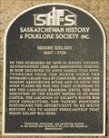
| HENRY KELSEY 1667 - 1724 in Saskatchewan Historical Markers The explorer Henry Kelsey (1667 - 1724) passed this spot during the summers of 1690-91, the first European to see the Canadian Prairies. posted by: anitamae location: Saskatchewan, Canada date approved: 03/12/2019 last visited: never |
 view gallery view gallery SE21.9 km SE21.9 km
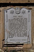
| Fort Pelly in Saskatchewan Historical Markers Just west of Fort Pelly National Historic Site of Canada, this was the first site of Fort Pelly. posted by: Altima Voyageur location: Saskatchewan, Canada date approved: 01/27/2016 last visited: never |
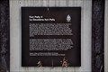 view gallery view gallerySE22.4 km | Fort Pelly National Historic Site of Canada in Saskatchewan Historical Markers Fort Pelly National Historic Site is South of HWY 8, East of 637. posted by: Altima Voyageur location: Saskatchewan, Canada date approved: 01/27/2016 last visited: never |
 view gallery view gallerySE22.4 km | CNHS Fort Pelly II - Le Deuxième fort Pelly in Canadian National Historic Sites Fort Pelly National Historic Site is South of Hwy 8, East of 637. posted by: Altima Voyageur location: Saskatchewan, Canada date approved: 10/30/2017 last visited: never |
 view gallery view galleryE23 km | Town of Pelly, History Billboards in Saskatchewan Historical Markers Located on South side of Pelly Saskatchewan. posted by: Altima Voyageur location: Saskatchewan, Canada date approved: 01/27/2016 last visited: never |
 view gallery view gallery S31.5 km S31.5 km
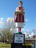
|  Lesia - Ukrainian Girl Lesia - Ukrainian Girl
in Roadside Attractions Lesia is located at the south end of Canora, Saskatchewan. posted by:  spud67 spud67 location: Saskatchewan, Canada date approved: 01/30/2006 last visited: 04/30/2011 |
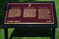
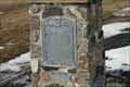 view gallery view galleryS31.5 km | Ukrainian Settlers of Canora in Saskatchewan Historical Markers A cairn and plaque acknowledging the first block settlement of Ukrainian immigrants in Saskatchewan. posted by: kjohn73 location: Saskatchewan, Canada date approved: 03/31/2010 last visited: never |
 view gallery view galleryS31.5 km | Welcome-Veetayemo, Town of Canora in Saskatchewan Historical Markers Located at Welcome Statue. posted by: Altima Voyageur location: Saskatchewan, Canada date approved: 01/27/2016 last visited: never |
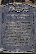 view gallery view galleryS31.7 km | Ukrainian Settlers of Canora in Saskatchewan Historical Markers Plaque is located on cairn located in from of Welcome Statue. posted by: Altima Voyageur location: Saskatchewan, Canada date approved: 01/27/2016 last visited: never |
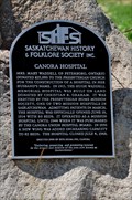 view gallery view gallerySW32.5 km | Canora Hospital in Saskatchewan Historical Markers Located near Pacific Street and Canora St. posted by: Altima Voyageur location: Saskatchewan, Canada date approved: 01/27/2016 last visited: never |
 view gallery view galleryS36.9 km | CNHS Doukhobors At Veregin in Canadian National Historic Sites This Canada Historic Site is on South side of tracks in town of Veregin, Saskatchewan. posted by: Altima Voyageur location: Saskatchewan, Canada date approved: 09/23/2017 last visited: never |
 view gallery view galleryS36.9 km | Doukhobors At Veregin, National Heritage Site in Saskatchewan Historical Markers This Canada Historic Site is on South side of tracks in town of Veregin, Saskatchewan. posted by: Altima Voyageur location: Saskatchewan, Canada date approved: 01/27/2016 last visited: never |
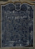 view gallery view gallerySE37.5 km | Gabriel Côté (MeeMay) in Saskatchewan Historical Markers North 8 km from Kamsack on HWY 8. posted by: Altima Voyageur location: Saskatchewan, Canada date approved: 01/27/2016 last visited: never |
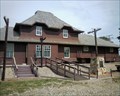 view gallery view gallerySW69.4 km |  Train Station - Theodore SK Train Station - Theodore SK
in Train Stations/Depots This train station in Theodore, Saskatchewan is now used as the Theodore Historical Museum. posted by: PeterNoG location: Saskatchewan, Canada date approved: 12/13/2010 last visited: 08/01/2009 |
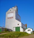 view gallery view gallerySW69.4 km |  Saskatchewan Wheat Pool Elevator - Theodore, SK Saskatchewan Wheat Pool Elevator - Theodore, SK
in Grain Elevators Large village - Small town. Theodore fits somewhere in there. With a population around 350, big village may be the better fit. It sits along the north side of the Yellowhead Highway, a short hop of 39 km. northwest of Yorkton, Saskatchewan. posted by: T0SHEA location: Saskatchewan, Canada date approved: 02/04/2013 last visited: 02/25/2014 |
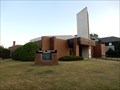 view gallery view galleryE72.3 km |  Temple Baptist Church - Swan River, Manitoba Temple Baptist Church - Swan River, Manitoba
in Baptist Churches A North American Baptist Conference church located in Swan River, MB posted by: Bon Echo location: Manitoba, Canada date approved: 11/23/2016 last visited: never |
 view gallery view galleryE72.4 km |  81M387 (Canada Geodetic Survey) - Swan River, MB 81M387 (Canada Geodetic Survey) - Swan River, MB
in Canadian Benchmarks Located on the back or RCMP building, this one should be safe from vandalism posted by: Bon Echo location: Manitoba, Canada date approved: 11/14/2015 last visited: never |
 view gallery view galleryE73.7 km |  The Swan River Valley - Swan River, MB The Swan River Valley - Swan River, MB
in Manitoba Historical Markers Two plaques located at the Swan Valley Museum just north of the town of Swan River, MB. posted by: Bon Echo location: Manitoba, Canada date approved: 11/18/2016 last visited: never |
|