 view gallery view gallery NE5.3 km NE5.3 km
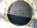
|   BM 90F037 approximately 3 Km SW of Salvage Newfoundland and Labrador BM 90F037 approximately 3 Km SW of Salvage Newfoundland and Labrador
in Canadian Benchmarks Canada Geodetic Survey marker Southwest of Salvage NL posted by:  YQX52 YQX52 location: Newfoundland and Labrador, Canada date approved: 05/22/2012 last visited: never |
 view gallery view gallery SW25.6 km SW25.6 km
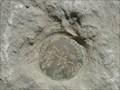
| Newfoundland Crown Land surveys marker # 637 (016) in Canadian Benchmarks Newfoundland crown lands survey marker 637 (016) posted by: YQX52 location: Newfoundland and Labrador, Canada date approved: 05/22/2012 last visited: 05/22/2012 |
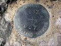 view gallery view gallerySW31.1 km | Newfoundland Crown Land Survey Marker No.637 (007) 9 Km. East of Terra Nova in Canadian Benchmarks A brass disc East of the community of Terra Nova in Newfoundland. posted by: YQX52 location: Newfoundland and Labrador, Canada date approved: 06/04/2008 last visited: 08/20/2009 |
 view gallery view gallery NW32 km NW32 km
| Dover Hilltop in Canadian Benchmarks Found near the Dover Fault Observation Deck. posted by: GOTNL location: Newfoundland and Labrador, Canada date approved: 10/18/2014 last visited: 09/23/2018 |
 view gallery view galleryNW37 km | Benchmark in Canadian Benchmarks On main HGYW between Gambo @ Hare Bay posted by: heyou location: Newfoundland and Labrador, Canada date approved: 07/16/2007 last visited: 06/25/2009 |
 view gallery view gallery SE40.4 km SE40.4 km
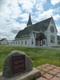
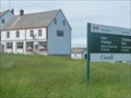
|  CNHP - John Clinch 1749-1819 - Trinity, Newfoundland and Labrador CNHP - John Clinch 1749-1819 - Trinity, Newfoundland and Labrador
in Canadian National Historic Sites This plaque has been placed in front of historic St. Paul's Anglican Church in Trinity, itself a historically designated landscape. Reverend Clinch was a medical pioneer who introduced a vaccine for smallpox. posted by: Trail Blaisers location: Newfoundland and Labrador, Canada date approved: 08/03/2015 last visited: 06/09/2018 |
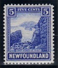 view gallery view gallerySE41.2 km |  Coastal Scene, Fort Point, Trinity, Newfoundland Coastal Scene, Fort Point, Trinity, Newfoundland
in Philatelic Photographs This stamp, issued in 1923, shows a view of the coastline looking southwest from Fort Point – a scene that has remained remarkably unchanged in all those intervening years. posted by: hykesj location: Newfoundland and Labrador, Canada date approved: 08/18/2017 last visited: 06/09/2018 |
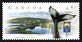 view gallery view gallerySE45.2 km | English Harbour, Newfoundland in Philatelic Photographs The small community of English Harbour is pictured on this Canadian postage stamp featuring the Discovery Trail scenic route in Newfoundland. posted by: hykesj location: Newfoundland and Labrador, Canada date approved: 11/23/2020 last visited: never |
 view gallery view gallery E45.7 km E45.7 km
|  Ryan Premises National Historic Site - Bonavista, Newfoundland and Labrador Ryan Premises National Historic Site - Bonavista, Newfoundland and Labrador
in Maritime Museums Ryan Premises National Historic Site was established in 1997, 500 years after the landing of John Cabot in Bonavista. It consists of a number of museum buildings which describe and animate the importance of the fishery and sealing industries. posted by: Trail Blaisers location: Newfoundland and Labrador, Canada date approved: 01/14/2019 last visited: never |
 view gallery view galleryE45.7 km | CNHS - The East Coast Fishery and the Ryan Premises - Bonavista, Newfoundland and Labrador in Canadian National Historic Sites Ryan Premises National Historic Site was established in 1997, 500 years after the landing of John Cabot in Bonavista. It consists of a number of museum buildings which describe and animate the importance of the fishery and sealing industries. posted by: Trail Blaisers location: Newfoundland and Labrador, Canada date approved: 08/03/2015 last visited: 06/09/2018 |
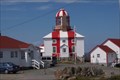 view gallery view galleryE48.3 km |  Cape Bonavista Lighthouse, Newfoundland, Canada Cape Bonavista Lighthouse, Newfoundland, Canada
in Coastal Lighthouses Sits on the northmost point of the Bonavista Peninsula in Newfoundland. posted by:  Team Polarbear Team Polarbear location: Newfoundland and Labrador, Canada date approved: 07/14/2007 last visited: 08/06/2017 |
 view gallery view gallery S50.4 km S50.4 km
|  B-36 Peacemaker crash site B-36 Peacemaker crash site
in Plane Crash Sites This crash that occured in the 1950's killed 17 airman posted by: JIMMIV77 location: Newfoundland and Labrador, Canada date approved: 09/10/2009 last visited: 08/26/2011 |
 view gallery view galleryE51.3 km |  Unveiling of The Sealers Memorial - Elliston, Newfoundland and Labrador Unveiling of The Sealers Memorial - Elliston, Newfoundland and Labrador
in News Article Locations On June 20, 2014, CBC carried a story about the unveiling of The Sealers Memorial in Elliston. It is a tribute to the 251 men who lost their lives in two separate disasters during a 1914 storm. posted by: Trail Blaisers location: Newfoundland and Labrador, Canada date approved: 08/19/2015 last visited: 06/09/2018 |
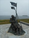
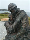
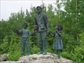
 view gallery view galleryE51.3 km |  The Sealers Memorial - Elliston, Newfoundland and Labrador The Sealers Memorial - Elliston, Newfoundland and Labrador
in Occupational Monuments The Sealers Memorial is a tribute to the 251 men who lost their lives in two separate disasters during a 1914 storm. The bronze sculpture is sorrowful - of a father and son holding one another as they brave the elements with little hope of survival. posted by: Trail Blaisers location: Newfoundland and Labrador, Canada date approved: 08/18/2015 last visited: 06/09/2018 |
 view gallery view galleryE51.3 km |  Home from The Sea Sealers Memorial - Elliston, Newfoundland and Labrador Home from The Sea Sealers Memorial - Elliston, Newfoundland and Labrador
in Maritime Monuments and Memorials The Sealers Memorial is a tribute to the 251 men who lost their lives in two separate disasters during a 1914 storm. The bronze sculpture is sorrowful - of a father and son holding one another as they brave the elements with little hope of survival. posted by: Trail Blaisers location: Newfoundland and Labrador, Canada date approved: 08/18/2015 last visited: 06/09/2018 |
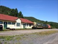 view gallery view galleryS53.9 km |  Clarenville Roundhouse - Clarenville, NL, Canada Clarenville Roundhouse - Clarenville, NL, Canada
in Railway Roundhouses Clarenville Roundhouse is located in Clarenville, Newfoundland and Labrador, Canada. posted by: tatie location: Newfoundland and Labrador, Canada date approved: 09/13/2017 last visited: never |
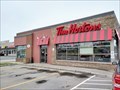 view gallery view galleryS55.5 km |  Tim Hortons - Manitoba Drive - Clarenville, NL Tim Hortons - Manitoba Drive - Clarenville, NL
in Tim Horton's Restaurants This Tims is between Booster Juice and McDonald's. posted by: elyob location: Newfoundland and Labrador, Canada date approved: 08/25/2022 last visited: never |
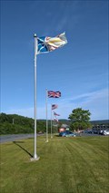 view gallery view galleryS56.8 km |  Clarenville Inn - Clarenville, Newfoundland, Canada Clarenville Inn - Clarenville, Newfoundland, Canada
in Flags of the World Safest access is from the Trans-Canada Highway westbound. posted by: elyob location: Newfoundland and Labrador, Canada date approved: 08/02/2021 last visited: never |
 view gallery view galleryNW69 km | Arrow Air Flight MF1285R in Plane Crash Sites The Arrow Air crash was the worst air disaster ever on Canadian soil. posted by: wilsonjw location: Newfoundland and Labrador, Canada date approved: 08/24/2005 last visited: 10/25/2022 |
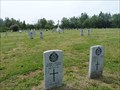 view gallery view galleryNW69.4 km |  Commonwealth War Graves - Gander, Newfoundland and Labrador Commonwealth War Graves - Gander, Newfoundland and Labrador
in Veteran Cemeteries Gander was the most important launching point for Europe-bound Allied aircraft during WWII. Unfortunately, many airmen and soldiers lost their lives here during training or other accidents. 100 are buried here. posted by: Trail Blaisers location: Newfoundland and Labrador, Canada date approved: 08/17/2015 last visited: never |
 view gallery view galleryNW70.8 km |  Gander International Airport - Gander, Newfoundland and Labrador, Canada Gander International Airport - Gander, Newfoundland and Labrador, Canada
in Airports Gander International's heyday was in the 1940s to 1950s when it was a frequent stopover for planes needing to refuel between Europe and North America. It was also a major training ground during WWII. posted by: Trail Blaisers location: Newfoundland and Labrador, Canada date approved: 07/19/2015 last visited: never |
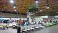 view gallery view galleryNW70.8 km |  Inside Gander International Airport - Gander, Newfoundland and Labrador Inside Gander International Airport - Gander, Newfoundland and Labrador
in Inside Airports Gander was once one of the busiest layover locations in the world when flights between North America and Europe needed to refuel here. Today, connections will get you to locations around the province and Maritimes. posted by: Trail Blaisers location: Newfoundland and Labrador, Canada date approved: 07/19/2015 last visited: never |
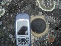
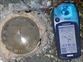 view gallery view galleryNW71.1 km | Geodetic Survey Gander 90F149 in Canadian Benchmarks Brass survey disk located near CFB Gander. posted by: GOTNL location: Newfoundland and Labrador, Canada date approved: 10/02/2006 last visited: 07/01/2007 |
 view gallery view galleryNW71.1 km |  Canadian Forces Base (9 Wing) Gander - Gander, Newfoundland and Labrador Canadian Forces Base (9 Wing) Gander - Gander, Newfoundland and Labrador
in Military Installations 9 Wing Gander was established in 1935. Once Canada went to war in 1939 it grew in importance. At one point, Winston Churchill referred to it as "the largest aircraft carrier in the North Atlantic". posted by: Trail Blaisers location: Newfoundland and Labrador, Canada date approved: 07/21/2019 last visited: never |
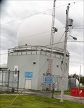 view gallery view galleryNW71.1 km |  Weather Radar - Gander, Newfoundland and Labrador Weather Radar - Gander, Newfoundland and Labrador
in Weather Radars This weather radar has been operational at Canadian Forces Base Gander since the summer of 1940. Gander was the most important launching point for Allied airplanes heading to/from Europe during WWII. posted by: Trail Blaisers location: Newfoundland and Labrador, Canada date approved: 07/21/2019 last visited: never |
|