 view gallery view gallery SE8.4 km SE8.4 km
|   Ephesus, Georgia Ephesus, Georgia
in Wikipedia Entries Ephesus is the youngest Heard County Municipality, the City of Ephesus was incorporated in 1964. posted by:  hummerstation hummerstation location: Georgia date approved: 03/02/2020 last visited: never |
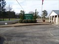
 view gallery view gallerySE8.4 km |  Ephesus, Georgia Ephesus, Georgia
in City and Town Halls The Ephesus City Hall is located on the east side of GA Highway 100. posted by: hummerstation location: Georgia date approved: 03/11/2020 last visited: never |
 view gallery view gallerySE8.4 km |  Ephesus, Georgia Ephesus, Georgia
in Names From the Bible Ephesus is a city in Heard County, Georgia, United States. The Ephesus of the Bible was a city in the Roman province of Asia. posted by: hummerstation location: Georgia date approved: 03/17/2020 last visited: never |
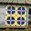
 view gallery view gallerySE8.5 km |  Overall Sam and Sunbonnet Sue Quilt Square - Ephesus, GA Overall Sam and Sunbonnet Sue Quilt Square - Ephesus, GA
in Painted Barn Quilts The Overall Sam and Sunbonnet Sue Quilt Square is located on the Ephesus Elementary School building on GA Hwy 100. posted by: hummerstation location: Georgia date approved: 03/03/2020 last visited: never |
 view gallery view gallerySE8.7 km | Fan Quilt Square - Ephesus, GA in Painted Barn Quilts The Fan Quilt Square is located on what is now a storage building on GA Hwy 100. posted by: hummerstation location: Georgia date approved: 03/03/2020 last visited: never |
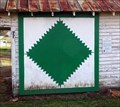 view gallery view gallerySE8.7 km | Sawtooth Quilt Square - Ephesus, GA in Painted Barn Quilts This Sawtooth Quilt Square is located on what is now a storage building on GA Hwy 100. posted by: hummerstation location: Georgia date approved: 03/03/2020 last visited: never |
 view gallery view gallery NE10.5 km NE10.5 km
|  Site of Bowdon College 1857-1936 - GHM 022-7 - Carroll Co., GA Site of Bowdon College 1857-1936 - GHM 022-7 - Carroll Co., GA
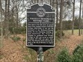
in Georgia Historical Markers Site of Bowdon College 1857-1936 located Ga 166 (W. College St) at Bowden High School in Bowden. posted by:  Lat34North Lat34North location: Georgia date approved: 05/12/2008 last visited: 01/11/2022 |
 view gallery view galleryNE10.6 km | Whatley Memorial Historic Park - Bowdon, GA in Georgia Historical Markers Located at Ellenwood Drive and College View Street, Bowdon posted by: Markerman62 location: Georgia date approved: 03/21/2022 last visited: never |
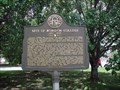
 view gallery view galleryNE10.9 km | Last Land in Georgia Ceded by the Creeks - GHM 022-2 - Carroll Co., GA in Georgia Historical Markers Last Land in Georgia Ceded by the Creeks located at the at the City Hall, City Hall Ave and Commerce St, Bowden, GA. posted by: Lat34North location: Georgia date approved: 05/12/2008 last visited: 01/11/2022 |
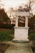
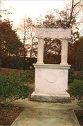
 view gallery view galleryNE10.9 km |  Vietnam War Memorial, Bowdon, GA, USA Vietnam War Memorial, Bowdon, GA, USA
in Vietnam War Memorials Vietnam War Memorial located at a small park on East Collage Street, Bowdon, GA. posted by: Lat34North location: Georgia date approved: 06/03/2008 last visited: 06/07/2014 |
 view gallery view gallery E17.5 km E17.5 km
| Log Cabin Quilt Square - Roopville, GA in Painted Barn Quilts This Log Cabin Quilt Square is located on the north side of an old building at the intersection of West Dr. and Old Highway 27. posted by: hummerstation location: Georgia date approved: 03/10/2020 last visited: never |
 view gallery view galleryE17.5 km |  Coca-Cola Sign - Roopville, GA Coca-Cola Sign - Roopville, GA
in Coca Cola Memorabilia This Coca- Cola sign is located on the north side of an old building at the intersection of West Dr. and Old Highway 27. posted by: hummerstation location: Georgia date approved: 03/10/2020 last visited: never |
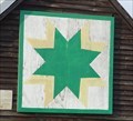 view gallery view gallerySE19.2 km | Eight-Point Star Quilt Square- Franklin, GA in Painted Barn Quilts This Eight-Point Star Quilt Square is located on the Hyatt farm mule barn located on GA Hwy 100. Coords were taken at the fence. posted by: hummerstation location: Georgia date approved: 03/03/2020 last visited: never |
 view gallery view gallery SW22.4 km SW22.4 km
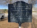
|  Site of the Home of William Hugh Smith Legislator, Governor - Wedowee, AL Site of the Home of William Hugh Smith Legislator, Governor - Wedowee, AL
in Alabama Historical Markers Located in the median of US 431 near Woodland Avenue, Wedowee posted by: Markerman62 location: Alabama date approved: 03/30/2022 last visited: never |
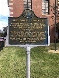 view gallery view gallerySW22.5 km | Randolph County in Alabama Historical Markers Located in front of the Randolph County Courthouse. posted by: flyingmoose location: Alabama date approved: 12/18/2021 last visited: 01/11/2022 |
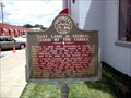
 view gallery view galleryNE23 km | First "REA" Substation in Carroll County, GA in Georgia Historical Markers First "REA" Substation in Carroll County located at the sub-station on Maple Street (GA 166) at western city limit, Carrollton. posted by: Lat34North location: Georgia date approved: 05/12/2008 last visited: 01/11/2022 |
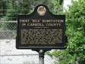 view gallery view galleryNE23 km |  First "REA" Substation in Carroll County, GA First "REA" Substation in Carroll County, GA
in First of its Kind First "REA" Substation in Carroll County located at the sub-station on Maple Street (GA 166) at western city limit, Carrollton. posted by: Lat34North location: Georgia date approved: 05/10/2008 last visited: 01/11/2022 |
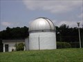 view gallery view galleryNE23.3 km |  West Georgia University Observatory, Carrollton, GA West Georgia University Observatory, Carrollton, GA
in Astronomical Observatories University of West Georgia Observatory, located on campus, Carrollton, GA. posted by: Lat34North location: Georgia date approved: 05/18/2008 last visited: 02/01/2009 |
 view gallery view gallery N24 km N24 km
| Hernando De Soto in Alabama - near Abernathy, AL in Alabama Historical Markers Marker in the picnic area of the Cleburne Welcome Center (I-20) posted by: YoSam. location: Alabama date approved: 03/02/2017 last visited: 11/04/2023 |
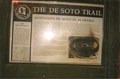
 view gallery view galleryN24 km |  The De Soto Trail - Abernathy, AL The De Soto Trail - Abernathy, AL
in Ancient Traces and Roads Marker in the picnic area of the Cleburne Welcome Center (I-20). This is the Alabama portion of the Trail posted by: YoSam. location: Alabama date approved: 02/21/2017 last visited: 11/04/2023 |
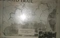
 view gallery view galleryN24 km |  The De Soto Trail - 1492 - 1702 - Abernathy, AL, USA The De Soto Trail - 1492 - 1702 - Abernathy, AL, USA
in Timelines Marker in the picnic area of the Cleburne Welcome Center (I-20) posted by: YoSam. location: Alabama date approved: 02/21/2017 last visited: 11/04/2023 |
 view gallery view galleryN24 km | The De Soto Trail - near Abernathy, AL in Alabama Historical Markers Marker in the picnic area of the Cleburne Welcome Center (I-20) posted by: YoSam. location: Alabama date approved: 03/02/2017 last visited: 11/04/2023 |
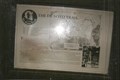
 view gallery view galleryN24 km |  Welcome Arch - 1942 - near Abernathy, Alabama Welcome Arch - 1942 - near Abernathy, Alabama
in Dated Architectural Structures Multifarious Rest area welcome sign erected in 1942 posted by: YoSam. location: Alabama date approved: 10/02/2022 last visited: 11/04/2023 |
 view gallery view galleryN24 km |  Welcome Arch - near Abernathy, Alabama Welcome Arch - near Abernathy, Alabama
in Freestanding Arches Rest area welcome sign erected in 1942 posted by: YoSam. location: Alabama date approved: 10/02/2022 last visited: 11/04/2023 |
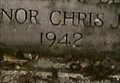
 view gallery view galleryN24 km |  The Unions 22nd State Welcomes You - near Abernathy, Alabama The Unions 22nd State Welcomes You - near Abernathy, Alabama
in Welcome Signs Rest area welcome sign erected in 1942 posted by: YoSam. location: Alabama date approved: 03/11/2017 last visited: 11/04/2023 |
|