 view gallery view gallery N5.6 km N5.6 km
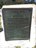
|   Pioneer Trail of Methodism - Shorter, AL Pioneer Trail of Methodism - Shorter, AL
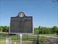
in Signs of History Tablet mounted to large piece of marble rock is located about 3 miles east of Shorter, Alabama on U.S. Highway 80. Notes the early arrival of Methodist minister to preach to the Creek Indians. posted by:  hoteltwo hoteltwo location: Alabama date approved: 10/20/2014 last visited: never |
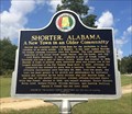
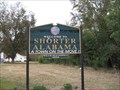
 view gallery view galleryN6 km |  "A Town On The Move!" - Shorter, Alabama "A Town On The Move!" - Shorter, Alabama
in Welcome Signs This welcome sign is located east of the town on US Highway 80, by the intersection with County Road 4, in Macon County, Alabama. posted by:  xptwo xptwo location: Alabama date approved: 12/07/2011 last visited: never |
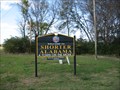
 view gallery view galleryN7.2 km |  Shorter, Alabama Shorter, Alabama
in Alabama Historical Markers Small rural town with a population of around 445 in Macon County. Located east of Montgomery close to Interstate 85 and U.S. 80 and near the Bartram Trail, located in the Tuskegee National Forest posted by: hoteltwo location: Alabama date approved: 10/11/2014 last visited: never |
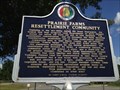 view gallery view gallery NW10.6 km NW10.6 km
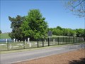
| Prairie Farms Resettlement Community - Shorter, AL in Alabama Historical Markers This marker for the Prairie Farms Resettlement Community is located at 45 Tysonville Road, approximately three miles from Shorter off of Highway 80. posted by: hoteltwo location: Alabama date approved: 08/12/2013 last visited: never |
 view gallery view galleryNW10.9 km | "A Town On The Move!" - Shorter, Alabama in Welcome Signs This welcome sign is located on US Highway 80 in Macon County, Alabama. posted by: xptwo location: Alabama date approved: 11/15/2011 last visited: 11/22/2011 |
 view gallery view gallery W11.4 km W11.4 km
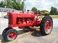
|  John Hall Tractor - Cecil, AL John Hall Tractor - Cecil, AL
in Old Tractors As You leave Montgomery, Alabama, heading east on Vaughn Road, you eventually get to the Cecil area. There on the side of the road you will see the John Hall store and this old tractor. posted by: xptwo location: Alabama date approved: 06/11/2013 last visited: never |
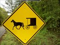
 view gallery view galleryW11.4 km |  Horse and Buggy Sign - Pike Road, Alabama Horse and Buggy Sign - Pike Road, Alabama
in Unusual Signs This sign might not seem unusual in Amish country, but the location in an area where the suburban town is Pike Road is growing makes it seem out of place at first glance. posted by: xptwo location: Alabama date approved: 05/22/2012 last visited: never |
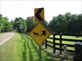 view gallery view galleryW11.4 km |  Horse and Buggy Crossing Sign - Pike Road, Alabama Horse and Buggy Crossing Sign - Pike Road, Alabama
in Uncommon Crossing Signs In the eastern part of Montgomery County, Alabama, one can find roads leading to new subdivisions and to older country farms or estates. This sign is on a road that starts with housing but continues on to horse farms. posted by: xptwo location: Alabama date approved: 04/14/2012 last visited: never |
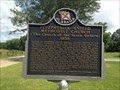
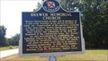 view gallery view galleryW11.4 km | Brewer Memorial Church - Cecil, AL in Alabama Historical Markers Describes the history of a local community church in rural Cecil, Alabama (Montgomery County) posted by: hoteltwo location: Alabama date approved: 09/19/2013 last visited: never |
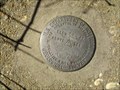 view gallery view galleryN11.6 km |  Macon County (AL) Road 9 Geological survey marker disk Macon County (AL) Road 9 Geological survey marker disk
in U.S. Benchmarks Geological Survey marker located on the southwest corner of a bridge over I-85 on CR 9. posted by: OHail location: Alabama date approved: 12/06/2011 last visited: 05/19/2013 |
 view gallery view galleryW12.2 km | Buggy Crossing, Montgomery County AL in Uncommon Crossing Signs A sign to watch for horse and buggy crossing the road way in rural Montgomery County AL. posted by: OHail location: Alabama date approved: 04/08/2012 last visited: 04/08/2012 |
 view gallery view gallery S12.9 km S12.9 km
| Church of the Seven Sisters (1858) - Fitzpatrick, AL in Alabama Historical Markers This marker is located in front of the Fitzpatrick United Methodist Church (UMC), also known as the Church of the Seven Sisters, established in 1858. It is located on Fitzpatrick Rd. posted by: hoteltwo location: Alabama date approved: 07/29/2013 last visited: 04/25/2022 |
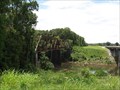 view gallery view galleryN13 km |  Tallapoosa River Bridge - Tallassee, Alabama Tallapoosa River Bridge - Tallassee, Alabama
in Railroad Bridges This abandoned two-span railroad bridge over the Tallapoosa River is south of Tallassee, Alabama. posted by: xptwo location: Alabama date approved: 07/15/2012 last visited: never |
 view gallery view galleryW13.2 km | Lucas Hill Cemetery - Pike Road, Alabama in Alabama Historical Markers Marker telling the story of the relocation and restoration of this historic cemetery in May 2005 by the developers of The Waters. posted by: xptwo location: Alabama date approved: 03/26/2012 last visited: 07/24/2013 |
 view gallery view galleryW13.2 km |  Lucas Hill Cemetery - Pike Road, Alabama Lucas Hill Cemetery - Pike Road, Alabama
in Worldwide Cemeteries Lucas Hill Cemetry is one of the oldest cemeteries in Alabama. It was relocated and restored by May 2005 by the developers of The Waters. posted by: xptwo location: Alabama date approved: 03/29/2012 last visited: never |
 view gallery view galleryW13.4 km |  18 MPH - The Waters - Pike Road, Alabama 18 MPH - The Waters - Pike Road, Alabama
in Unusual Speed Limits This 18 MPH sign can be seen in The Waters, a development in Pike Road, Alabama. posted by: xptwo location: Alabama date approved: 04/04/2012 last visited: never |
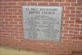 view gallery view galleryW14.2 km |  2003-St. Paul Missionary Baptist Church Cornerstone, Waugh AL 2003-St. Paul Missionary Baptist Church Cornerstone, Waugh AL
in Dated Buildings and Cornerstones Cornerstone of the new sanctuary of the St. Paul Missionary Baptist Church posted by: OHail location: Alabama date approved: 03/24/2012 last visited: never |
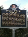 view gallery view galleryW14.5 km | Lucas Tavern / Circa 1818 - Montgomery, Alabama in Alabama Historical Markers Located east of Montgomery, this marker tells of the history of Lucas Tavern before it was moved downtown. posted by: xptwo location: Alabama date approved: 11/22/2011 last visited: 11/22/2011 |
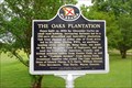 view gallery view galleryW14.5 km | The Oaks Plantation in Alabama Historical Markers Marker giving a bit of history of the Oaks Plantation, located in rural Montgomery County posted by: OHail location: Alabama date approved: 03/23/2012 last visited: 02/27/2014 |
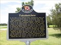 view gallery view galleryN15.9 km | Tukabatchee - Tallassee, Alabama in Alabama Historical Markers This two-sided marker about one of the Creek Confederacy capitals is unusual in that the north side is in English while the south side is in Creek. posted by: xptwo location: Alabama date approved: 08/16/2012 last visited: 08/16/2014 |
 view gallery view gallery NE16.9 km NE16.9 km
| Franklin's Educational Legacy - Franklin, AL in Alabama Historical Markers Marker placed during the Great Alabama Homecoming in 2010 highlighting some history of education in rural Macon County. posted by: hoteltwo location: Alabama date approved: 08/23/2013 last visited: never |
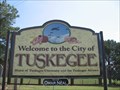 view gallery view galleryNE17.2 km | Home of Tuskegee University and the Tuskegee Airmen - Tuskegee, AL in Welcome Signs There are several welcome signs in Tuskegee. This one is located west of town on U.S. Highway 80. posted by: xptwo location: Alabama date approved: 12/02/2012 last visited: never |
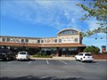 view gallery view galleryW18.7 km |  No Way Jose Grill and Cantina - Pike Road, AL No Way Jose Grill and Cantina - Pike Road, AL
in Mexican Restaurants The folks at No Way Jose Grill and Cantina have opened a second restaurant in Pike Road. They are in the same complex with the Pike Road City Hall and Pike Road Branch Library. posted by: xptwo location: Alabama date approved: 06/16/2013 last visited: 01/06/2015 |
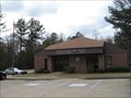 view gallery view galleryW19 km |  Pike Road, AL - 36064 Pike Road, AL - 36064
in U.S. Post Offices The Pike Road, Alabama, Post Office is located at 1320 Pike Road, near the intersection with Vaughn Road. posted by: xptwo location: Alabama date approved: 12/21/2011 last visited: never |
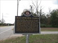 view gallery view galleryW19.2 km | Grace Episcopal Church - Pike Road, Alabama in Alabama Historical Markers Marker telling the story of Grace Episcopal Church in Pike Road, Alabama. It is a nineteenth century church that reflects its rural roots. posted by: xptwo location: Alabama date approved: 12/18/2011 last visited: 08/31/2013 |
|