 view gallery view gallery NE12.1 km NE12.1 km
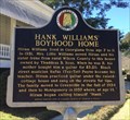
|   Hank Williams' Boyhood Home - Georgiana, AL Hank Williams' Boyhood Home - Georgiana, AL
in Alabama Historical Markers Located on Rose Street, this marker is in front of the old boyhood home of country music legend Hank Williams, Sr. The home today is a museum. posted by:  hoteltwo hoteltwo location: Alabama date approved: 03/12/2015 last visited: never |
 view gallery view galleryNE12.1 km | Thigpen’s Log Cabin Popular Dance Hall - Georgiana, AL in Alabama Historical Markers The log cabin is located behind the Hank Williams Boyhood Home and Museum on Rose Street and is often used for festivals. posted by: hoteltwo location: Alabama date approved: 03/12/2015 last visited: never |
 view gallery view gallery SW18.5 km SW18.5 km
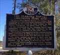
| Alabama Baptist Children’s Home Site - Evergreen, AL in Alabama Historical Markers Former location of widows and orphans home located at the intersection of S. Main St and Cemetery Ave in front of the old Evergreen Junior High School gymnasium. posted by: hoteltwo location: Alabama date approved: 03/22/2015 last visited: never |
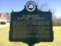 view gallery view gallerySW18.8 km | Evergreen Baptist Church - Evergreen, AL in Alabama Historical Markers Marker located on Park St notes the beginnings of the Evergreen Baptist Church and lists the pastors and lists the pastorates as well. posted by: hoteltwo location: Alabama date approved: 03/12/2015 last visited: never |
 view gallery view gallerySW19 km |  Evergreen, AL 36401 Evergreen, AL 36401
in U.S. Post Offices This fine old Post Office serves Evergreen, Alabama. posted by:  The Snowdog The Snowdog location: Alabama date approved: 01/28/2023 last visited: never |
 view gallery view gallerySW19 km |  Evergreen Courant - Evergreen, AL Evergreen Courant - Evergreen, AL
in Newspaper Headquarters The Evergreen Courant has been providing the news since 1895 - in Evergreen, Alabama. posted by: The Snowdog location: Alabama date approved: 01/28/2023 last visited: never |
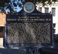 view gallery view gallerySW19 km | Ernest Stanley Crawford, M.D. - Evergreen, AL in Alabama Historical Markers Located along the railroad tracks in the historic district, this marker notes the life of a renowned vascular surgeon born in this city. posted by: hoteltwo location: Alabama date approved: 03/12/2015 last visited: never |
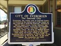 view gallery view gallerySW19.2 km | City of Evergreen (The Emerald City) - Evergreen, AL in Alabama Historical Markers Marker located right next to the old Evergreen Train Depot near Front Street. The depot has been refurbished and is across from the Evergreen Historic District. posted by: hoteltwo location: Alabama date approved: 03/12/2015 last visited: never |
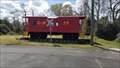 view gallery view gallerySW19.2 km |  L & N Caboose 39 - Evergreen, AL L & N Caboose 39 - Evergreen, AL
in Train Cabooses L & N Caboose 39 is displayed next to the Evergreen Depot. posted by: hummerstation location: Alabama date approved: 04/07/2022 last visited: never |
 view gallery view gallery N20.3 km N20.3 km
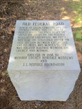
| Old Federal Road - Shackleville, AL in Alabama Historical Markers One of eight stone markers along the Alabama portion of the Federal road established as a postal route by President Jefferson. Located on County Road 38 just west of County Road 7. posted by: hoteltwo location: Alabama date approved: 07/22/2015 last visited: never |
 view gallery view gallery NW22.5 km NW22.5 km
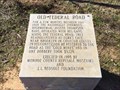
| Old Federal Road - Midway Alabama in Alabama Historical Markers One of eight stone markers along the Alabama portion of the Federal road established as a postal route by President Jefferson. Located at the intersection of County Road 1 and State Route 83 in Conecuh County. posted by: hoteltwo location: Alabama date approved: 03/24/2015 last visited: never |
 view gallery view galleryNW24.8 km | Midway - Midway, AL in Alabama Historical Markers Marker notes the community started here and is located at the intersection of State, County and U.S. highways. It should not to be confused with the incorporated town of Midway that’s located in Bullock County. posted by: hoteltwo location: Alabama date approved: 03/12/2015 last visited: never |
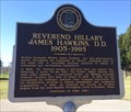 view gallery view gallerySW25.7 km | Reverend Hillary James Hawkins, D.D. (1905-1995) - Lime Hill, AL in Alabama Historical Markers Marker is at the intersection of Brown Hawkins Road and Fall Lane off U.S. Highway 84 and in a small lay by. The street was name after him. Notes his life history in the area. posted by: hoteltwo location: Alabama date approved: 03/12/2015 last visited: never |
 view gallery view gallery E26.1 km E26.1 km
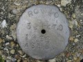
|  Ala. State Hwy. Dept. ROW 40 39+470 1966 Ala. State Hwy. Dept. ROW 40 39+470 1966
in U.S. Benchmarks Alabama Highway Department ROW marker in Butler County posted by: jkselby location: Alabama date approved: 03/10/2008 last visited: 03/17/2012 |
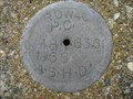 view gallery view galleryE26.4 km | Ala. State Hwy. Dept. ROW P.C. 40 48+63.6 1966 in U.S. Benchmarks Alabama Highway Dept. Right of Way marker in Butler County posted by: jkselby location: Alabama date approved: 03/17/2008 last visited: 03/17/2012 |
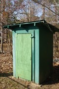 view gallery view galleryNE27.4 km |  Mt. Olive East Church Outhouse Mt. Olive East Church Outhouse
in Outhouses Two seater outhouse at a rural church in LA (lower Alabama). posted by: OHail location: Alabama date approved: 01/19/2012 last visited: 03/09/2012 |
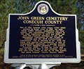 view gallery view gallery W27.7 km W27.7 km
| John Green Cemetery - Burnt Corn, AL in Alabama Historical Markers Located near the community of Burnt Corn, this cemetery contains Civil War and war of 1812 graves. The cemetery is well off the main road and you will need some GPS sense to find it. The cemetery is now well taken care of. posted by: hoteltwo location: Alabama date approved: 03/12/2015 last visited: never |
 view gallery view galleryW28.2 km | Old Federal Road - Pine Orchard, AL in Alabama Historical Markers One of eight stone markers along the Alabama portion of the Federal road established as a postal route by President Jefferson. Located on County Road 5, south of County Road 42. posted by: hoteltwo location: Alabama date approved: 03/24/2015 last visited: never |
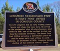 view gallery view galleryW28.2 km | Longmire Stagecoach Stop - Burnt Corn, AL in Alabama Historical Markers Marker located along the rural County Road 5, north of Burnt Corn. Notes the early history of Conecuh County postal service. posted by: hoteltwo location: Alabama date approved: 03/22/2015 last visited: never |
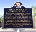 view gallery view galleryW28.3 km | First School in Conecuh County - Burnt Corn, AL in Alabama Historical Markers Located on Conecuh County Road 15, east of County Road 5 this marker notes the former location of the first school in this rural county. posted by: hoteltwo location: Alabama date approved: 03/22/2015 last visited: never |
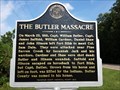 view gallery view galleryN29.1 km | The Butler Massacre - Forest Home, AL in Alabama Historical Markers Replacement marker describing the history of the naming of Butler County and its namesake. posted by: hoteltwo location: Alabama date approved: 08/28/2013 last visited: 06/15/2019 |
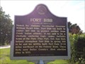 view gallery view galleryN29.1 km | Fort Bibb - Forest Home, AL in Alabama Historical Markers Replacement marker describing the construction and use of Fort Bibb. posted by: hoteltwo location: Alabama date approved: 08/28/2013 last visited: never |
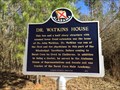 view gallery view galleryW29.3 km | Dr. Watkins House - Burnt Corn, AL in Alabama Historical Markers Located on Conecuh County Rd 5, about a mile north of CR-15, notes the house and life of a prominent doctor and politician, John Watkins. posted by: hoteltwo location: Alabama date approved: 03/22/2015 last visited: never |
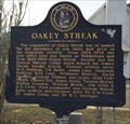 view gallery view galleryE29.6 km | Oakey Streak - Butler County, AL in Alabama Historical Markers Marker describes the early settling of a community named Oakey Streak, in lower rural Butler County, off County Road 59. posted by: hoteltwo location: Alabama date approved: 12/14/2013 last visited: never |
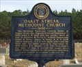 view gallery view galleryE29.6 km | Oakey Streak Methodist Church - Butler County, AL in Alabama Historical Markers Marker describes history of this historic church. The church and cemetery next to it are on the National Register of Historic Places. posted by: hoteltwo location: Alabama date approved: 12/14/2013 last visited: never |
|