 view gallery view gallery NE0.2 km NE0.2 km
|   Historic and Beautiful Repton - Repton, AL Historic and Beautiful Repton - Repton, AL
in Alabama Historical Markers Located on Alabama Highway 41 near McMillan Street, the marker describes the history of Repton, the beginning of railroads in the area and the withering economy and population of the town and its desire to grow again. posted by:  hoteltwo hoteltwo location: Alabama date approved: 01/17/2017 last visited: 08/27/2019 |
 view gallery view gallery N4.5 km N4.5 km
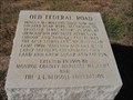
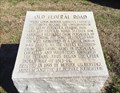
| Old Federal Road - Repton, Alabama in Alabama Historical Markers Marker indicating the location of a stage stop on Old Federal Road. It is located north of Repton, Alabama. posted by:  xptwo xptwo location: Alabama date approved: 11/30/2011 last visited: 03/07/2015 |
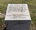 view gallery view galleryNE9.7 km | Old Federal Road - Bermuda, AL in Alabama Historical Markers One of eight stone markers along the Alabama portion of the Federal road established as a postal route by President Jefferson. Located at the intersection of County Road 5 and County Road 20. posted by: hoteltwo location: Alabama date approved: 03/24/2015 last visited: never |
 view gallery view gallery NW11.9 km NW11.9 km
|  Lambert's - Foley, Alabama Lambert's - Foley, Alabama
in Independent Diners Lambert's - Home of the Thrown Rolls, Lambert's Foley, Alabama, location. posted by: gwtriker location: Alabama date approved: 06/03/2010 last visited: 03/06/2015 |
 view gallery view gallery SE14.6 km SE14.6 km
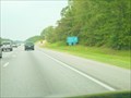
|  I-65 Rest Area Mile Marker 58 I-65 Rest Area Mile Marker 58
in Highway Rest Areas A rest area on Interstate 65 North in southern Alabama. posted by: ggmorton location: Alabama date approved: 09/21/2007 last visited: 04/30/2021 |
 view gallery view gallerySE14.6 km |  I-65 NB Conecuh County Rest Area - Castleberry, Alabama I-65 NB Conecuh County Rest Area - Castleberry, Alabama
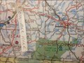
in 'You Are Here' Maps You Are Here Map in the Conecuh County NB Rest Area building lobby. posted by: theHostas location: Alabama date approved: 04/26/2019 last visited: 04/06/2019 |
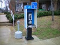 view gallery view gallerySE14.6 km |  Northbound I-65 Rest Stop Payphone #3 Northbound I-65 Rest Stop Payphone #3
in Payphones A Payphone located at the northbound I-65 Rest Stop around mile marker 85. posted by: Six Little Spookies location: Alabama date approved: 01/26/2008 last visited: 01/19/2008 |
 view gallery view gallerySE14.6 km | I-65 north rest area phone #1 in Payphones This is one of two pay phones located just outside the rest area on I-65 northbound in southern Alabama. Maintained by Talton Communications. posted by: Lazer location: Alabama date approved: 10/30/2007 last visited: 01/19/2008 |
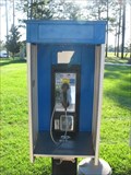 view gallery view gallerySE14.6 km | I-65 north rest area phone #2 in Payphones This is 1 of 2 payphones just outside the I-65 northbound rest area in southern Alabama. Serviced by Talton Communications. posted by: Lazer location: Alabama date approved: 10/30/2007 last visited: 01/19/2008 |
 view gallery view gallery W15 km W15 km
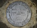
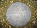
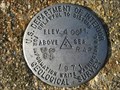
|  US Geological Survey elevation marker 413 FT 27 RAP 1971 US Geological Survey elevation marker 413 FT 27 RAP 1971
in U.S. Benchmarks USGS vertical control mark 1 mile NE of Frisco City, AL posted by: jkselby location: Alabama date approved: 12/21/2007 last visited: never |
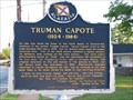 view gallery view galleryNW15.1 km | Truman Capote in Alabama Historical Markers Monroeville home of Truman Capote. posted by: Thorny1 location: Alabama date approved: 07/11/2008 last visited: 07/11/2010 |
 view gallery view galleryNW15.4 km |  Old Monroe County Courthouse - To Kill A Mockingbird Old Monroe County Courthouse - To Kill A Mockingbird
in Literary Sites Old Monroeville County Courthouse - the setting for the famous courtroom scene in "To Kill A Mockingbird" by Harper Lee. posted by: Thorny1 location: Alabama date approved: 07/22/2008 last visited: 07/11/2010 |
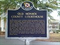 view gallery view galleryNW15.4 km | Old Monroe County Courthouse - Monroeville, AL in Alabama Historical Markers Historical Marker commemorating the Old Monroe County Courthouse, made famous from the novel and movie, "To Kill A Mockingbird, posted by: Six Little Spookies location: Alabama date approved: 02/02/2008 last visited: 04/12/2014 |
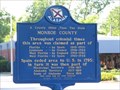 view gallery view galleryNW15.4 km | A County Older Then The State - Monroe County in Alabama Historical Markers Monroe County, Alabama is older then the state itself - created in 1815, Alabama did not become a state until 1819. posted by: Thorny1 location: Alabama date approved: 07/11/2008 last visited: 07/31/2011 |
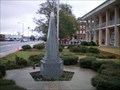 view gallery view galleryNW15.4 km |  Monroeville, AL Eternal Flame Monroeville, AL Eternal Flame
in Eternal Flames Eternal Flame outside the Monroeville, Alabama, Courthouse. posted by: Six Little Spookies location: Alabama date approved: 01/27/2008 last visited: 01/21/2008 |
 view gallery view gallery E17.4 km E17.4 km
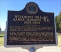
| Reverend Hillary James Hawkins, D.D. (1905-1995) - Lime Hill, AL in Alabama Historical Markers Marker is at the intersection of Brown Hawkins Road and Fall Lane off U.S. Highway 84 and in a small lay by. The street was name after him. Notes his life history in the area. posted by: hoteltwo location: Alabama date approved: 03/12/2015 last visited: never |
 view gallery view galleryNE17.5 km | Old Federal Road - Burnt Corn, AL in Alabama Historical Markers One of eight stone markers along the Alabama portion of the Federal road established as a postal route by President Jefferson. Located at the intersection of County Road 5 and County Road 15. posted by: hoteltwo location: Alabama date approved: 03/24/2015 last visited: never |
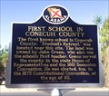 view gallery view galleryNE17.5 km | First School in Conecuh County - Burnt Corn, AL in Alabama Historical Markers Located on Conecuh County Road 15, east of County Road 5 this marker notes the former location of the first school in this rural county. posted by: hoteltwo location: Alabama date approved: 03/22/2015 last visited: never |
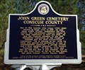 view gallery view galleryNE17.7 km | John Green Cemetery - Burnt Corn, AL in Alabama Historical Markers Located near the community of Burnt Corn, this cemetery contains Civil War and war of 1812 graves. The cemetery is well off the main road and you will need some GPS sense to find it. The cemetery is now well taken care of. posted by: hoteltwo location: Alabama date approved: 03/12/2015 last visited: never |
 view gallery view galleryW17.9 km | US Geological Survey elevation marker 404 FT 86 RAP 1971 in U.S. Benchmarks USGS elevation mark 2 miles SW of Frisco City, Alabama posted by: jkselby location: Alabama date approved: 12/21/2007 last visited: never |
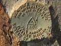 view gallery view galleryW17.9 km | Ala. State Hwy. Dept. UE 13 1962 in U.S. Benchmarks An Ala. State Highway Dept. survey mark located on AL 21, north of Megargel, Alabama. posted by: jkselby location: Alabama date approved: 12/05/2007 last visited: never |
 view gallery view galleryW17.9 km | USGS survey mark 1971, near Megargel, AL in U.S. Benchmarks A USGS vertical control mark, third order or better with tablet. posted by: jkselby location: Alabama date approved: 12/05/2007 last visited: never |
 view gallery view galleryE18.3 km | I-65 SB Conecuh, Alabama in Highway Rest Areas Rest Area on SB I-65 in Clanton, Kentucky. posted by: theHostas location: Alabama date approved: 04/26/2019 last visited: 03/30/2019 |
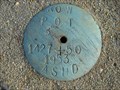 view gallery view galleryNW18.3 km | 1427 + 50 in U.S. Benchmarks Alabama State Highway Dept. ROW marker on AL 47 near Mexia, Alabama posted by: jkselby location: Alabama date approved: 12/15/2007 last visited: never |
 view gallery view galleryE18.3 km | I-65 SB Conecuh County Rest Area - Castleberry, Alabama in 'You Are Here' Maps You Are Here in rest area building. posted by: theHostas location: Alabama date approved: 04/25/2019 last visited: 03/30/2019 |
|