 view gallery view gallery N12.1 km N12.1 km
|   Isaac Nettles Gravestones - Carlton, Alabama Isaac Nettles Gravestones - Carlton, Alabama
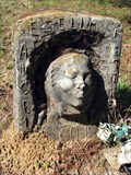
in Wikipedia Entries Death mask gravestones in Mt. Nebo Baptist Church cemetery near Carlton, Alabama. posted by:  BruceS BruceS location: Alabama date approved: 09/24/2013 last visited: never |
 view gallery view galleryN12.1 km |  Nettles, Isaac, Gravestones - Carlton, Alabama Nettles, Isaac, Gravestones - Carlton, Alabama
in U.S. National Register of Historic Places Death mask gravestones in Mt. Nebo Baptist Church cemetery near Carlton, Alabama. posted by: BruceS location: Alabama date approved: 10/31/2009 last visited: never |
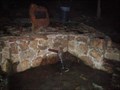
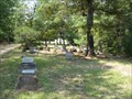 view gallery view galleryN12.1 km |  Mt Nebo Baptist Church Cemetery - Carlton, Alabama Mt Nebo Baptist Church Cemetery - Carlton, Alabama
in Worldwide Cemeteries Small churchyard cemetery in rural area near Carlton, Alabama. posted by: BruceS location: Alabama date approved: 11/01/2009 last visited: never |
 view gallery view galleryN12.1 km |  Mt Nebo Baptist Church Cemetery - Carlton, Alabama Mt Nebo Baptist Church Cemetery - Carlton, Alabama
in Churchyard Cemeteries Small churchyard cemetery in rural area near Carlton, Alabama. posted by: BruceS location: Alabama date approved: 11/01/2009 last visited: never |
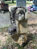
 view gallery view galleryN12.1 km |  Mother Nettles - Carlton, Alabama Mother Nettles - Carlton, Alabama
in Death Mask Gravestones Gravestone with three death masks in a rural cemetery in Clarke County, Alabama. posted by: BruceS location: Alabama date approved: 09/25/2009 last visited: never |
 view gallery view galleryN12.1 km | Ezella Nettles - Carlton, Alabama in Death Mask Gravestones One of three death mask gravestones in this small cemetery in rural Clarke County, Alabama. posted by: BruceS location: Alabama date approved: 09/25/2009 last visited: never |
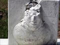 view gallery view galleryN12.1 km | Manul Burell - Carlton, Alabama in Death Mask Gravestones One of three death mask gravestones in this small cemetery in rural Clarke County, Alabama. posted by: BruceS location: Alabama date approved: 09/26/2009 last visited: never |
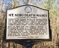 view gallery view galleryN12.1 km |  Mt. Nebo Death Masks - Carlton, AL Mt. Nebo Death Masks - Carlton, AL
in Alabama Historical Markers At the Mt. Nebo Baptist Church, in the nearby cemetery, there are three graves that have very unusual markings. The headstones on these graves contain “death masks”. These headstones were crafted by Isaac Nettles, Sr. (1885 – 1957). posted by:  hoteltwo hoteltwo location: Alabama date approved: 03/02/2017 last visited: never |
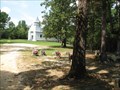
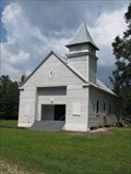 view gallery view galleryN12.1 km |  Mt. Nebo Baptist Church - Carlton, AL Mt. Nebo Baptist Church - Carlton, AL
in Baptist Churches Rural Baptist Church near Carlton, Alabama. posted by: BruceS location: Alabama date approved: 10/31/2009 last visited: never |
 view gallery view galleryN12.1 km |  Mt Nebo Baptist Church - Carlton, Alabama Mt Nebo Baptist Church - Carlton, Alabama
in This Old Church Rural Baptist Church near Carlton, Alabama. posted by: BruceS location: Alabama date approved: 10/31/2009 last visited: never |
 view gallery view galleryN12.1 km | Mt Nebo Baptist Church - Carlton, Alabama in Country Churches Rural Baptist Church near Carlton, Alabama. posted by: BruceS location: Alabama date approved: 11/03/2009 last visited: 02/25/2017 |
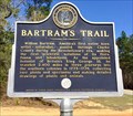 view gallery view galleryN15.9 km | Bartram's Trail - Rockville, Alabama in Alabama Historical Markers One of many markers noting the trail of William Bartram on his quest for obtaining and documenting natural features of the southern colonies. entrance to the Fred T. Stimpson Wildlife Sanctuary on Rockville Rd. (County Rd 15). posted by: hoteltwo location: Alabama date approved: 03/02/2017 last visited: never |
 view gallery view gallery S16.3 km S16.3 km
|  Red Hill Spring, Latham, AL Red Hill Spring, Latham, AL
in Artesian Well Red Hill Spring Located on Highway 59 north of Latham, AL. posted by:  Six Little Spookies Six Little Spookies location: Alabama date approved: 01/27/2008 last visited: 11/23/2013 |
 view gallery view galleryS16.3 km |  Red Hill Spring, Latham, AL Red Hill Spring, Latham, AL
in Natural Springs Natural spring located on Highway 59 north of Latham, AL. posted by: Six Little Spookies location: Alabama date approved: 01/20/2008 last visited: 06/06/2008 |
 view gallery view gallery W17.7 km W17.7 km
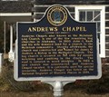
| Andrews Chapel - McIntosh, AL in Alabama Historical Markers One of the last log cabin churches in Alabama, built in 1860, and was also a community center. posted by: hoteltwo location: Alabama date approved: 12/05/2013 last visited: never |
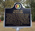 view gallery view galleryW17.9 km | Town of McIntosh - McIntosh, AL in Alabama Historical Markers Marker describes the Town of McIntosh and its roots and current status. posted by: hoteltwo location: Alabama date approved: 12/05/2013 last visited: never |
 view gallery view gallery NE18.2 km NE18.2 km
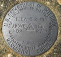
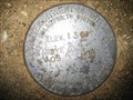
|  U.S. Geological Survey elevation marker 62 FT 102 RAP 1971 U.S. Geological Survey elevation marker 62 FT 102 RAP 1971
in U.S. Benchmarks USGS elevation mark 2.8 miles north of Chrysler, Monroe County posted by: jkselby location: Alabama date approved: 11/24/2009 last visited: never |
 view gallery view galleryNE19.8 km | Mt. Pleasant Methodist Church - near Uriah, AL in Alabama Historical Markers Notes the architecture and history of the building of this Methodist Church. It also describes the local industry that sprouted up in the community around this old church. posted by: hoteltwo location: Alabama date approved: 07/17/2024 last visited: never |
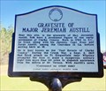 view gallery view galleryN20.4 km | Gravesite of Major Jeremiah Austill - Rockville, AL in Alabama Historical Markers Marker is along Rockville Rd (County Rd 15) at Suel Rd and describes the nearby location of a famous folk hero of the Creek Indian Wars. Noted as the "Paul Revere of Clarke County." posted by: hoteltwo location: Alabama date approved: 03/02/2017 last visited: never |
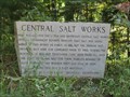 view gallery view galleryN22.5 km | Central Salt Works - Jackson, Alabama in Alabama Historical Markers Historical marker for a former salt works in rural area south of Jackson, Alabama. posted by: BruceS location: Alabama date approved: 10/31/2009 last visited: never |
 view gallery view galleryNE22.5 km | US Geological Survey elevation marker 136 FT 105 RAP 1971 in U.S. Benchmarks USGS elevation marker on CR 1 near Eliska Church posted by: jkselby location: Alabama date approved: 11/04/2009 last visited: never |
 view gallery view gallery SW23.2 km SW23.2 km
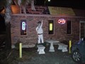
|  Bar-Be-Quing With My Honey - Mt Vernon, AL Bar-Be-Quing With My Honey - Mt Vernon, AL
in Classic BBQ and Sandwich Joints Mom-and-Pop Barbeque restaurant in Mount Vernon, AL on Highway 43. posted by: Six Little Spookies location: Alabama date approved: 01/24/2008 last visited: 10/19/2009 |
 view gallery view gallerySW23.5 km |  Southern Railway Depot - Mt. Vernon, AL Southern Railway Depot - Mt. Vernon, AL
in Train Stations/Depots Acquired in 2010 this former train depot is now used by the Mt Vernon Alabama Historical Preservation Society. posted by: hoteltwo location: Alabama date approved: 12/10/2013 last visited: never |
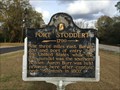 view gallery view gallerySW23.7 km | Fort Stoddert (1799) - Mt. Vernon, AL in Alabama Historical Markers Constructed in 1799, Fort Stoddert was located at the Mount Vernon Landing on the Mobile River in Mobile County east of current day Mount Vernon and was named for the Acting Secretary of War Benjamin Stoddert. posted by: hoteltwo location: Alabama date approved: 12/05/2013 last visited: 09/30/2019 |
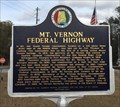 view gallery view gallerySW23.7 km | Mt. Vernon Federal Highway - Mt Vernon, AL in Alabama Historical Markers Describes the history of the establishment of the Federal Highway and other events in Mt. Vernon, Alabama. posted by: hoteltwo location: Alabama date approved: 12/05/2013 last visited: 09/30/2019 |
|