 view gallery view gallery NE3.5 km NE3.5 km
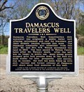
|   Damascus Travelers Well - Damascus, AL Damascus Travelers Well - Damascus, AL
in Alabama Historical Markers Located at intersection of Well & Damascus Roads west of Anadalusia, the marker notes importance of this rural well to the community. posted by:  hoteltwo hoteltwo location: Alabama date approved: 03/09/2019 last visited: never |
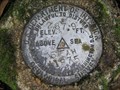
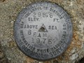
 view gallery view galleryNE3.5 km |  USGS Elevation 217.6 - Brewton, AL USGS Elevation 217.6 - Brewton, AL
in U.S. Benchmarks Benchmark beside an old well. posted by: WERL location: Alabama date approved: 02/03/2013 last visited: never |
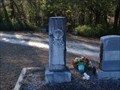 view gallery view gallery E4 km E4 km
|  W. H. Hoomes - Damascus Cemetery - Brewton, AL W. H. Hoomes - Damascus Cemetery - Brewton, AL
in Woodmen of the World Grave Markers/Monuments The W. H. Hoomes Woodmen of the World grave marker is located in the Damascus Cemetery, also known as the Douglas Chapel Cemetery. posted by:  hummerstation hummerstation location: Alabama date approved: 03/04/2022 last visited: never |
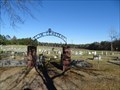
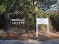 view gallery view galleryE4 km |  Damascus Cemetery - Brewton, AL Damascus Cemetery - Brewton, AL
in Worldwide Cemeteries Damascus Cemetery is a located next to Douglas Chapel United Methodist Church on US Highway 29 in Escambia County Alabama. posted by: hummerstation location: Alabama date approved: 03/30/2022 last visited: never |
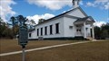
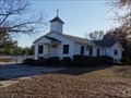 view gallery view galleryE4 km |  Douglas Chapel United Methodist Church - Douglas Chapel United Methodist Church -
in Methodist Churches Douglas Chapel United Methodist Church is located at 16394 Highway 29 North. posted by: hummerstation location: Alabama date approved: 04/01/2022 last visited: never |
 view gallery view gallery S6 km S6 km
|  Elim Cemetery - Roberts, AL Elim Cemetery - Roberts, AL
in Churchyard Cemeteries Elim Cemetery is located next to Elim Baptist Church on Bradley Road in Escambia County Alabama. posted by: hummerstation location: Alabama date approved: 04/02/2022 last visited: never |
 view gallery view galleryS6 km | Elim Cemetery - Roberts, AL in Worldwide Cemeteries Elim Cemetery is located on Bradley Road in Escambia County Alabama. posted by: hummerstation location: Alabama date approved: 03/31/2022 last visited: never |
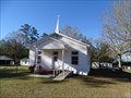 view gallery view galleryS6 km |  Elim Baptist Church - Roberts, AL Elim Baptist Church - Roberts, AL
in This Old Church Elim Baptist Church is located on Bradley Road in Escambia County, Alabama. According to the historical marker the current building was erected in 1920. posted by: hummerstation location: Alabama date approved: 04/02/2022 last visited: never |
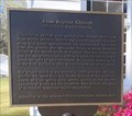 view gallery view galleryS6 km | Elim Baptist Church in Alabama Historical Markers The Elim Baptist Church historical marker is located in front of the church. posted by: hummerstation location: Alabama date approved: 03/30/2022 last visited: never |
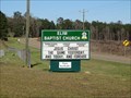 view gallery view galleryS6 km |  Elim Baptist Church - Roberts, AL Elim Baptist Church - Roberts, AL
in Baptist Churches Elim Baptist Church is located on Bradley Road in Escambia County, Alabama. According to the historical marker the current building was erected in 1920. posted by: hummerstation location: Alabama date approved: 04/03/2022 last visited: never |
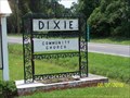 view gallery view galleryE14.3 km | Dixie Community Church Cemetery - Dixie, AL in Worldwide Cemeteries Dixie Community Church Cemetery, Escambia County, Dixie, AL posted by: hummerstation location: Alabama date approved: 08/23/2010 last visited: never |
 view gallery view gallery N14.6 km N14.6 km
| US Geological Survey elevation marker 288 FT 5 FAH 1975 in U.S. Benchmarks USGS elevation marker near Johnstonville posted by: jkselby location: Alabama date approved: 04/18/2008 last visited: never |
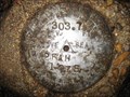 view gallery view galleryN15.1 km | US Geological Survey elevation marker 304 FT 2 FAH 1975 in U.S. Benchmarks USGS elevation benchmark on County Rd. 6 near Brooklyn posted by: jkselby location: Alabama date approved: 04/18/2008 last visited: never |
 view gallery view galleryNE16.1 km | Brooklyn Baptist Church - Brooklyn, AL in This Old Church Brooklyn Baptist Church is located on Conecuh County Road 6. According to the historical marker the current sanctuary was completed in October 1861. posted by: hummerstation location: Alabama date approved: 03/31/2022 last visited: never |
 view gallery view galleryNE16.1 km | Brooklyn Baptist Church - Brooklyn, AL in Baptist Churches Brooklyn Baptist Church is located on Conecuh County Road 6. According to the historical marker the current sanctuary was completed in October 1861. posted by: hummerstation location: Alabama date approved: 04/03/2022 last visited: never |
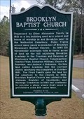 view gallery view galleryNE16.1 km | Brooklyn Baptist Church in Alabama Historical Markers The Brooklyn Baptist Church historical marker is located in front of the church on Conecuh County Road 6. posted by: hummerstation location: Alabama date approved: 03/30/2022 last visited: never |
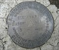 view gallery view galleryNE16.3 km | U.S. Geological Survey 30-U-18 1967 in U.S. Benchmarks U.S.G.S. mark 1 mile southeast of Brooklyn, Conecuh County posted by: jkselby location: Alabama date approved: 01/12/2011 last visited: never |
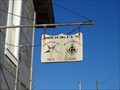 view gallery view galleryNE16.4 km |  Dean Lodge 112 - Brooklyn, AL Dean Lodge 112 - Brooklyn, AL
in Masonic Temples Dean Lodge 112 is located on Brooklyn Road. posted by: hummerstation location: Alabama date approved: 04/04/2022 last visited: never |
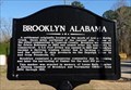 view gallery view galleryNE16.4 km | Brooklyn, Alabama - Brooklyn, AL in Alabama Historical Markers The Brooklyn, Alabama historical marker is located near what was probably the Post Office at one time. posted by: hummerstation location: Alabama date approved: 03/21/2022 last visited: never |
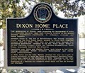 view gallery view galleryE16.4 km | Dixon Home Place - Near Andalusia, AL in Alabama Historical Markers Located at the Solon Dixon Forestry Education Center run by Auburn University, the marker notes the contributions of the Dixon Family and the building of the Forestry education center. posted by: hoteltwo location: Alabama date approved: 03/09/2019 last visited: never |
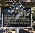 view gallery view galleryE16.4 km | History of the Dixon Home - Near Andalusia, AL in Alabama Historical Markers The Dixon home was moved here to be part of the Solon Dixon Forestry Education Center here. The marker describes the history of the house and the Dixon family. The marker is located on Dixon Center Road 20 miles west of Andalusia. posted by: hoteltwo location: Alabama date approved: 03/09/2019 last visited: never |
 view gallery view galleryN16.7 km | US Geological Survey elevation marker 296 FT 6 FAH 1975 in U.S. Benchmarks USGS elevation benchmark at Cedar Creek Church posted by: jkselby location: Alabama date approved: 04/09/2008 last visited: never |
 view gallery view galleryNE17.2 km | US Geological Survey elevation marker 139 FT M ENGR. B.N. 1967 in U.S. Benchmarks USGS elevation marker at CR 43 bridge over Bottle Creek near Brooklyn posted by: jkselby location: Alabama date approved: 04/21/2008 last visited: never |
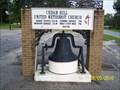 view gallery view gallery SW17.7 km SW17.7 km
|  CEDAR HILL UNITED METHODIST CHURCH BELL - East Brewton, AL CEDAR HILL UNITED METHODIST CHURCH BELL - East Brewton, AL
in Bells CEDAR HILL UNITED METHODIST CHURCH BELL, East Brewton, AL posted by: hummerstation location: Alabama date approved: 08/23/2010 last visited: 02/03/2013 |
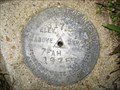 view gallery view gallery NW17.7 km NW17.7 km
| US Geological Survey elevation marker 317.5 FT 7 FAH 1975 in U.S. Benchmarks USGS benchmark at L Pond Church, Conecuh County, AL posted by: jkselby location: Alabama date approved: 03/06/2008 last visited: never |
|