 view gallery view gallery N3.9 km N3.9 km
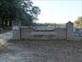
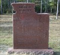
|   Creola Cemetery - Creola, AL Creola Cemetery - Creola, AL
in Worldwide Cemeteries Creola Cemetery is located behind the Creola United Methodist Church off of Highway 43 and on James Burkett Lane. posted by:  hummerstation hummerstation location: Alabama date approved: 01/28/2019 last visited: never |
 view gallery view galleryN3.9 km |  Charles Hudgens - Creola Cemetery - Creola, AL Charles Hudgens - Creola Cemetery - Creola, AL
in Woodmen of the World Grave Markers/Monuments The Charles Hudgens Woodmen of the World memorial is located in the Creola Cemetery. posted by: hummerstation location: Alabama date approved: 01/27/2019 last visited: never |
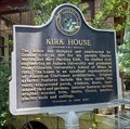 view gallery view galleryN7.9 km |  Kirk House - Axis, Alabama Kirk House - Axis, Alabama
in Alabama Historical Markers The Kirk family beginnings in the area started with saw mills. Ancestors still live in the house and it is open for events and tours. posted by:  hoteltwo hoteltwo location: Alabama date approved: 07/09/2023 last visited: never |
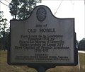 view gallery view galleryN10.8 km | Site of Old Mobile in Alabama Historical Markers Marks the nearby location of the French Fort Louis de la Louisiane built in 1702. posted by: hoteltwo location: Alabama date approved: 12/05/2013 last visited: never |
 view gallery view gallery SW10.9 km SW10.9 km
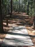
|  Chickasabogue Disc Golf Course Chickasabogue Disc Golf Course
in Disc Golf Courses Mobile, AL: 18 hole disc golf course in Chickasabogue County Park posted by: The Yoyo Man location: Alabama date approved: 11/26/2006 last visited: never |
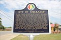 view gallery view gallery S11.3 km S11.3 km
| City of Chickasaw in Alabama Historical Markers In the town of Chickasaw. posted by: Markerman62 location: Alabama date approved: 04/28/2014 last visited: 12/09/2017 |
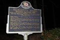
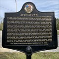 view gallery view galleryS14.3 km | Africatown - Mobile, AL in Alabama Historical Markers Located on Bay Bridge Rd at Magazine St notes the last known slave ship of enslaved Africans forced to come to America on the slave ship, the Clotilda. It also describes the settlement of the descendants and their culture. posted by: hoteltwo location: Alabama date approved: 12/26/2020 last visited: never |
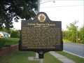 view gallery view galleryS14.3 km | Union Baptist Church in Alabama Historical Markers This historic marker and church are located in Africa Town, just north of Mobile, AL. posted by: Team Min Dawg location: Alabama date approved: 10/26/2008 last visited: 07/26/2015 |
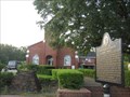 view gallery view galleryS14.3 km |  Union Missionary Baptist Church - Mobile, AL Union Missionary Baptist Church - Mobile, AL
in Baptist Churches This church and its historic marker are located in Africa Town, just north of Mobile, AL. posted by: Team Min Dawg location: Alabama date approved: 10/10/2010 last visited: 07/25/2015 |
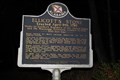
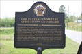 view gallery view galleryS14.5 km | Old Plateau Cemetery Africatown Graveyard in Alabama Historical Markers In the corner of the cemetery north of downtown. posted by: Markerman62 location: Alabama date approved: 04/28/2014 last visited: 07/26/2015 |
 view gallery view galleryN15.1 km |  Ellicott's Stone -- nr Mobile AL Ellicott's Stone -- nr Mobile AL
in Engineering Landmarks In 1968 the American Society of Civil Engineers named the Ellicott Stone a US National Civil Engineering Landmark. posted by: Benchmark Blasterz location: Alabama date approved: 02/14/2015 last visited: 09/30/2019 |
 view gallery view galleryN15.1 km |  FIRST -- Southern Boundary of the US, nr Mobile AL FIRST -- Southern Boundary of the US, nr Mobile AL
in First of its Kind The Ellicott Stone marks the first Southern boundary between the United States and what was, in 1799, Spanish Florida. It also serves as the initial point (or Zero Stone) for all public land surveys in the Mississippi territory. posted by: Benchmark Blasterz location: Alabama date approved: 02/13/2015 last visited: 09/30/2019 |
 view gallery view galleryN15.1 km | FIRST -- Survey Point for Public Lands in Mississippi Territory, nr Mobile AL in First of its Kind The Ellicott Stone serves as the initial point (or Zero Stone) for all public land surveys in the Mississippi territory. posted by: Benchmark Blasterz location: Alabama date approved: 02/13/2015 last visited: 09/30/2019 |
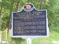 view gallery view galleryN15.1 km | Ellicott's Stone - Mobile County, Alabama in Alabama Historical Markers National boundary between US and Spanish in 1799. posted by: Thorny1 location: Alabama date approved: 07/09/2008 last visited: 09/30/2019 |
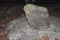
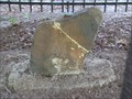 view gallery view galleryN15.3 km |  Ellicott's Stone - Mobile County, AL - US/Spanish Border Marker Ellicott's Stone - Mobile County, AL - US/Spanish Border Marker
in U.S. Historic Survey Stones and Monuments The stone marker, a ferruginous sandstone block about two feet high and eight inches thick, is near the west bank of the Mobile River. On the northern side of the stone is an inscription stating "U.S. Lat. 31, 1799." The inscription on the southern side reads "Dominio De S.M. Carlos IV, Lat. 31, 1799." (Dominion of his majesty King Charles IV, Lat. 31, 1799) posted by: Thorny1 location: Alabama date approved: 07/09/2008 last visited: 09/30/2019 |
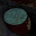 view gallery view galleryN15.3 km |  O 9 ELLICOTT STONE - BH0103 O 9 ELLICOTT STONE - BH0103
in U.S. Benchmarks A U.S. Coast & Geodetic Survey and State Survey disc on top of the Ellicott Stone. posted by: Thorny1 location: Alabama date approved: 07/10/2008 last visited: 09/30/2019 |
 view gallery view gallery SE17.7 km SE17.7 km
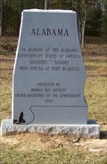
|  Alabama Memorial - Historic Blakeley State Park, AL Alabama Memorial - Historic Blakeley State Park, AL
in American Civil War Monuments and Memorials Alabama Memorial, Historic Blakeley State Park, AL posted by: hummerstation location: Alabama date approved: 02/04/2012 last visited: 03/03/2013 |
 view gallery view gallerySE17.7 km | Missouri Memorial - Historic Blakeley State Park, AL in American Civil War Monuments and Memorials Missouri Memorial, Historic Blakeley State Park, AL posted by: hummerstation location: Alabama date approved: 02/05/2012 last visited: 12/26/2014 |
 view gallery view gallerySE17.7 km | Alabama Memorial - Historic Blakeley State Park, AL in Alabama Historical Markers Memorial to the Alabama troops, soldiers and sailors, who fought at Fort Blakely. The Battle of Fort Blakely actually took place after the surrender at Appomattox. posted by: hummerstation location: Alabama date approved: 07/09/2012 last visited: 03/03/2013 |
 view gallery view gallerySE17.7 km | Missouri Memorial - Historic Blakeley State Park, AL in Alabama Historical Markers Memorial to the Missouri troops, Fedral and Confederate, who fought at Fort Blakely. The Battle of Fort Blakely actually took place after the surrender at Appomattox. posted by: hummerstation location: Alabama date approved: 07/09/2012 last visited: 12/26/2014 |
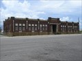 view gallery view galleryS17.9 km |  Southern Railway Freight Depot - Mobile, Alabama Southern Railway Freight Depot - Mobile, Alabama
in Train Stations/Depots This vacant freight depot stands adjacent to the restored GM&O Station in Mobile, Alabama. posted by: Bluejacket01 location: Alabama date approved: 07/28/2008 last visited: 01/16/2022 |
 view gallery view galleryS17.9 km | Gulf, Mobile, and Ohio Railroad Station - Mobile, Alabama in Train Stations/Depots The station was constructed in 1905-1906 by the Mobile & Ohio Railroad and was designed by architect P. Thorton Mayre; the total cost was $575,000. posted by: Bluejacket01 location: Alabama date approved: 07/28/2008 last visited: 01/16/2022 |
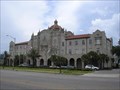
 view gallery view galleryS17.9 km |  Gulf, Mobile, and Ohio Passenger Terminal Gulf, Mobile, and Ohio Passenger Terminal
in U.S. National Register of Historic Places The station was constructed in 1905-1906 by the Mobile & Ohio Railroad and was designed by architect P. Thorton Mayre; the total cost was $575,000.
posted by: Bluejacket01 location: Alabama date approved: 08/03/2008 last visited: 01/16/2022 |
 view gallery view galleryS17.9 km |  GM&O Railroad Station Chimera - Mobile, Alabama GM&O Railroad Station Chimera - Mobile, Alabama
in Gargoyles and Chimeras A pair of chimera guarding the entrance to this impressive railroad station (now a refurbished office building). posted by: Bluejacket01 location: Alabama date approved: 07/27/2008 last visited: 01/16/2022 |
 view gallery view gallerySE17.9 km | Blakely Cemetery - Historic Blakely State Park, AL in Worldwide Cemeteries Blakely Cemetery, Historic Blakeley State Park, AL posted by: hummerstation location: Alabama date approved: 02/06/2012 last visited: 03/03/2013 |
|