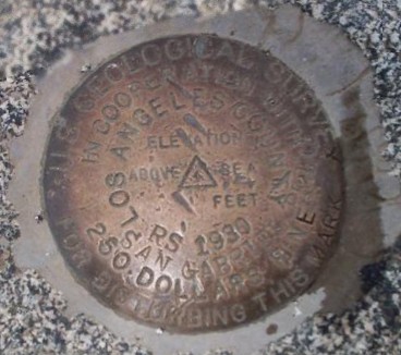
San Gabriel Peak RS30 Benchmark
Posted by:  showbizkid
N 34° 14.592 W 118° 05.915
11S E 398835 N 3789667
Very Old Orphaned USGS Benchmark on San Gabriel Peak, CA.
Waymark Code: WM4GP
Location: California, United States
Date Posted: 12/04/2005
Views: 57
This benchmark is located on the summit of San Gabriel Peak above Pasadena, CA. The BM appears on some USGS Topo Maps, but not in the database. This peak was first surveyed in 1875. In 1894, the USGS used the summit as a triangulation point for mapping the San Gabriel Mountain Range. As it appeared to be the highest point in the front range of the San Gabriels, the government surveyors gave it the name "San Gabriel Peak". More recent surveys show nearby Strawberry Peak is actually 3 feet higher.
This benchmark was placed in 1930 and is in good condition. It is possible that since Strawberry Peak is the higher peak, this BM was decommissioned.
Easy to locate at the peak, it is a few feet west of the bench.
To log your visit to this waymark, post your own photo of the waymark and leave some brief comments. Logs without photos will be archived. Thanks.