Nichols Park - Henryetta, OK
Posted by:  hamquilter
N 35° 24.738 W 095° 58.870
15S E 229294 N 3922850
The CCC did extensive work at Nichols Park between 1938 and 1941. The coordinates shown above are at the entrance on the northwest side of the park.
Waymark Code: WMYGTB
Location: Oklahoma, United States
Date Posted: 06/14/2018
Views: 1
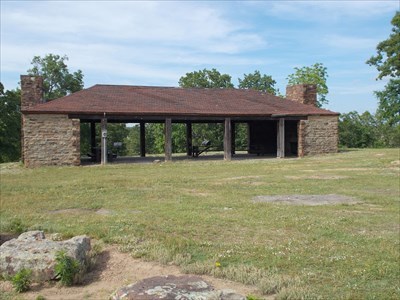
Nichols Park was developed by the Civilian Conservation Corps (CCC) and the National Park Service (NPS). The CCC constructed several stone buildings, including a bathhouse, two large pavilions, restrooms, and picnic tables, as well as culverts, water faucets and fire pits in the park.
The bathhouse is located on the east side of the lake. It is a one-story building constructed of crudely cut, coursed and rusticated native sandstone. The interior rooms have been opened up for use as a picnic pavilion. The facade facing the lake is open at the center, with an overhang gable. The interior roof rafters are exposed. Leading down toward the beach is a wide, oval set of seven stone stairs, and a stone patio. Another set of stone stairs leads from the bathhouse northeast and up a hill to the parking lot.
There are two stone pavilions, each with large fireplaces at either end. Stone picnic tables are built throughout the park, as well as a stone restroom. Nichols Lake is a large man-made lake with beach swimming and fishing.